| Location | Central Iran, Isfahan Province |
| Coordinates | 34°18′N 51°42′E |
| Area | Approx. 2,400 km² (930 sq mi) |
| Desert Type | Salt flat (kavir) desert |
| Average Elevation | ~800–900 m above sea level |
| Daytime Temperature | Up to +45°C (113°F) in summer |
| Nighttime Temperature | Can drop to −20°C (−4°F) in winter |
| Annual Precipitation | Less than 100 mm per year |
| Main Feature | Maranjab Salt Lake (Hoz-e Soltan outskirts) and sand dunes |
| Nearest City | Aran va Bidgol (~45 km south) |
| Protected Status | Part of the Central Kavir Protected Area |
| Access Road | Via Maranjab Caravanserai route from Aran va Bidgol |
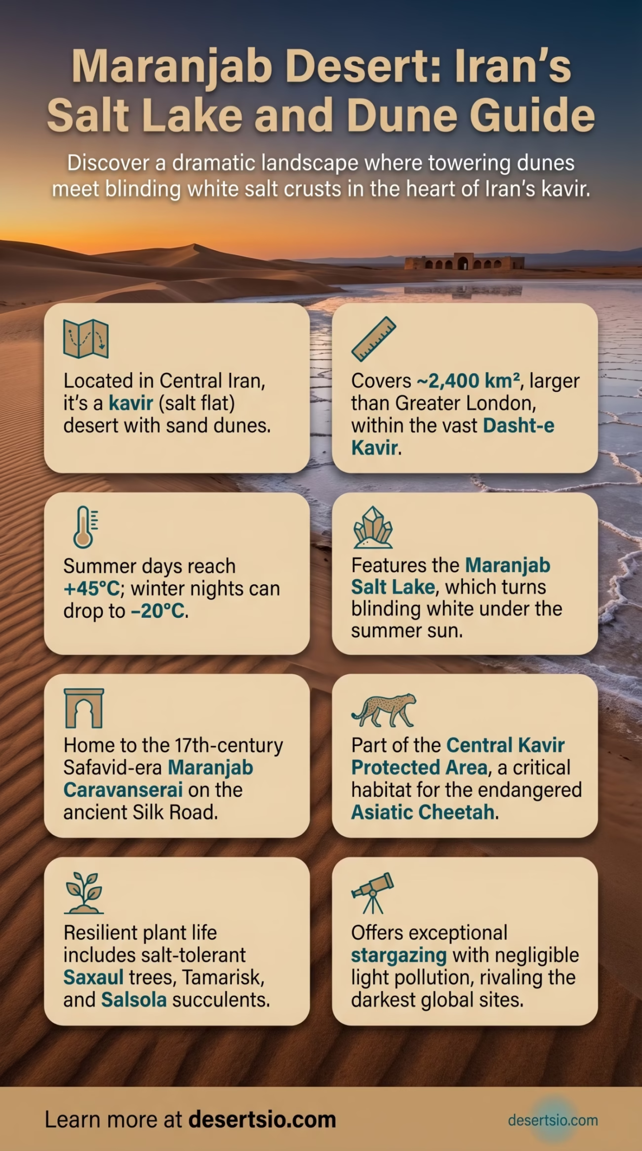
Maranjab Desert sits in the heart of Iran’s vast kavir (salt flat) landscape, roughly 60 kilometers north of Kashan in Isfahan Province. It is not just another expanse of sand. Here, towering dunes stand directly beside blinding white salt crusts — two completely different desert landscapes compressed into a single, startling terrain. Few places on Earth offer that kind of contrast so sharply, so close together.
- What Kind of Desert Is Maranjab?
- Maranjab Desert: Location and Map View
- Formation: How Maranjab Came to Be
- How Big Is Maranjab?
- Temperature Extremes: A Desert of Two Faces
- Flora and Fauna: Life at the Edge
- Plants
- Animals
- The Maranjab Salt Lake and Caravanserai
- Human Life: Who Lives Here?
- Maranjab in the Context of Iran’s Desert System
- Neighboring Deserts and Regional Context
- Conservation and Current Challenges
- Desert Terminology: A Brief Glossary
- The Silk Road Connection
- Maranjab vs. Mesr Desert
- Maranjab vs. Varzaneh Desert
- Stargazing and Atmospheric Clarity
- Key Facts Overview
What Kind of Desert Is Maranjab?
Maranjab is classified as a kavir desert — a Persian term for the salt-encrusted lowland plains that dominate central Iran. The word kavir comes from the Old Persian root describing a dry, barren basin. Unlike the purely sandy Sahara or the rocky Atacama, kavir deserts combine salt flats, sand dunes, and seasonal mudflats in unpredictable patterns. Maranjab is one of the most accessible and well-defined examples of this type.
The desert is part of the larger Dasht-e Kavir — Iran’s Great Salt Desert — which stretches over 77,000 km² across the Iranian plateau. To put that in perspective, Dasht-e Kavir alone is larger than the entire country of Ireland. Maranjab occupies a more defined, reachable pocket within this immense system.
Maranjab Desert: Location and Map View
Formation: How Maranjab Came to Be
The geological story of Maranjab goes back millions of years. The Iranian plateau was once partially covered by ancient inland seas and lakes during the Tethys Ocean era. As tectonic shifts uplifted the Zagros and Alborz mountain ranges, these water bodies became sealed off from outside drainage. Evaporation — relentless, over millennia — left behind massive salt deposits. The result: the kavir crust that defines the desert floor today.
Sand dunes in Maranjab formed through a separate but overlapping process. Wind-driven aeolian sediment, carried from surrounding highland erosion zones, accumulated along the edges of the salt flats. Where dunes meet the salt lake edge — that’s where Maranjab becomes genuinely extraordinary. It’s a geological collision, frozen in place.
How Big Is Maranjab?
Maranjab itself covers approximately 2,400 km². That’s larger than the entire city of London (1,572 km²), or roughly comparable to the U.S. state of Rhode Island. While that might seem modest next to the Sahara, within Iran’s kavir belt, Maranjab punches well above its weight in terms of terrain diversity and ecological complexity.
When combined with the surrounding Central Kavir Protected Area — which extends the protected zone significantly — the total landscape under some form of conservation consideration reaches far beyond the desert’s formal boundaries.
Temperature Extremes: A Desert of Two Faces
Summer (Day): Surface temperatures can exceed +45°C (113°F), and the salt flat surface itself radiates additional heat, pushing felt temperatures even higher.
Summer (Night): Temperatures drop sharply after sunset — often falling 20–25°C within hours. Desert nights here are cool, sometimes cold, even in August.
Winter (Day): Mild to cool, ranging from 5°C to 15°C, with occasional sunshine.
Winter (Night): Can plunge to −20°C (−4°F) during cold snaps — a temperature range that shocks first-time visitors who associate deserts only with heat.
This extreme diurnal (day-night) temperature swing — sometimes exceeding 30°C in a single 24-hour period — is a defining feature of continental desert climates. It shapes everything: the soil, the biology, and the survival strategies of every organism that calls Maranjab home.
Flora and Fauna: Life at the Edge
Don’t let the salt crusts fool you. Maranjab is far from lifeless. The desert supports a surprisingly resilient collection of species adapted to saline soils, intense UV radiation, and scarce water.
Plants
- Haloxylon ammodendron (Saxaul tree) — the dominant shrub of the region, capable of storing water in its trunk and tolerating extreme salinity
- Salsola spp. — salt-tolerant succulents that stabilize loose desert soil
- Tamarix (Tamarisk) — found near seasonal water channels and the edges of the salt lake
- Artemisia — drought-resistant shrubs common across Central Asian desert margins
Animals
- Asiatic Cheetah (Acinonyx jubatus venaticus) — critically endangered; the Central Kavir Protected Area is one of its last confirmed habitats globally, with fewer than 12 individuals estimated in Iran
- Persian Gazelle (Gazella subgutturosa) — frequently spotted in the open areas around Maranjab
- Caracal — elusive nocturnal predator
- Desert Monitor Lizard (Varanus griseus) — one of the largest reptiles in the region
- Sandgrouse and Houbara Bustard — migratory birds that use the salt lake edges as stopover points
- Scorpions and Horned Vipers — the desert’s less photogenic but ecologically important residents
The presence of the Asiatic Cheetah alone makes this desert ecologically significant on a global scale. With the global population of this subspecies estimated at fewer than 50 individuals total, the kavir landscape around Maranjab is essentially irreplaceable.
The Maranjab Salt Lake and Caravanserai
At the northern edge of the desert lies the Maranjab Salt Lake — a shallow, seasonally flooded playa that turns blinding white under the summer sun. In winter, it occasionally holds a thin sheet of water, attracting flocks of flamingos and migratory waterfowl. The contrast between the rust-colored dunes and the white lake surface is one of the most photographed desert landscapes in Iran.
Standing nearby — and genuinely hard to miss — is the Maranjab Caravanserai, a Safavid-era rest stop built in the 17th century under Shah Abbas I. It served merchants traveling the Silk Road corridor between Kashan and Khorasan. The caravanserai is remarkably intact. Mud-brick walls, an inner courtyard, and the remnants of animal stalls still stand — a tangible architectural echo of the trade routes that once crossed these salt flats.
Human Life: Who Lives Here?
Maranjab itself has no permanent settlements. The nearest inhabited area is Aran va Bidgol, a small city roughly 45 km to the south, which serves as the practical gateway to the desert. Kashan, the larger regional hub, sits about 60 km away.
Historically, the area was traversed — not inhabited — by nomadic Qashqai and Shahsevan tribal groups who moved their flocks seasonally across the Iranian plateau. Some semi-nomadic herding activity continues in the peripheral zones today. The desert’s interior, particularly around the salt lake, has never supported permanent habitation due to the total absence of freshwater sources.
And yet, people have always been drawn here. The caravanserai is proof of that.
Maranjab in the Context of Iran’s Desert System
Iran is home to two major desert systems: the Dasht-e Kavir (Great Salt Desert) and the Dasht-e Lut (Lut Desert). Maranjab belongs to the Kavir system. Here’s how the key Iranian deserts compare:
| Desert | Area | Type | Notable Feature |
| Dasht-e Kavir | ~77,000 km² | Salt flat / kavir | Largest desert in Iran |
| Dasht-e Lut | ~51,800 km² | Rock / sand / hot salt | Hottest surface temperature on Earth (70.7°C recorded) |
| Maranjab Desert | ~2,400 km² | Salt flat / sand dune | Dunes meeting salt lake; Safavid caravanserai |
| Kavir National Park | ~4,000 km² | Kavir / wildlife reserve | UNESCO Biosphere Reserve; Asiatic Cheetah habitat |
Dasht-e Lut, recognized as a UNESCO World Heritage Site since 2016, recorded the highest land surface temperature ever measured on Earth — 70.7°C (159.3°F) via NASA satellite data. Maranjab is cooler but more accessible and more ecologically varied.
Neighboring Deserts and Regional Context
Maranjab doesn’t exist in isolation. The broader kavir belt connects it to several other significant desert zones across the region:
- Kavir National Park — directly adjacent, a protected biosphere reserve with similar kavir topography and overlapping wildlife populations
- Dasht-e Kavir (Great Salt Desert) — the parent landscape of which Maranjab is a part; stretches east into South Khorasan Province
- Mesr Desert — another kavir-adjacent dune field, southeast of Maranjab near Khur, known for its star dunes and small oasis village
- Varzaneh Desert — south of Isfahan, also on the Kavir margin; similar dune fields but with a different silica sand composition
- Dasht-e Lut — further southeast; shares the same tectonic origin but represents an entirely different desert subtype (rock and gravel serir surface rather than salt flat)
If Maranjab is compared to a desert outside Iran, the Rub’ al Khali (Empty Quarter) of Arabia shares the concept of massive salt flats embedded within sand seas — though at a scale roughly 250 times larger. A closer parallel in terms of size and salt-dune combination would be Salar de Uyuni in Bolivia, although that is a high-altitude salt flat rather than a hot desert.
Conservation and Current Challenges
Maranjab falls within the Central Kavir Protected Area, managed by Iran’s Department of Environment. Conservation here focuses primarily on protecting the Asiatic Cheetah corridor and controlling the overgrazing that threatens the desert’s fragile halophyte vegetation cover (salt-tolerant plants).
In recent years, desertification pressure has intensified around the kavir margins due to groundwater depletion and changing precipitation patterns. The salt lake itself has shown signs of shrinkage during drought years — a trend observed across many of Iran’s closed-basin lakes, most notably Lake Urmia in the northwest, which has lost over 80% of its surface area since the 1970s. Maranjab’s salt lake is smaller and less monitored, but the broader hydrological stress is the same.
Off-road vehicle traffic — particularly around the dune fields — poses a direct threat to surface biological crusts. These crusts, made of cyanobacteria, lichens, and microfungi, are invisible but critical: they bind loose desert soil and prevent accelerated dune migration. A single vehicle track can destroy decades of crust development. This is not a hypothetical risk. It’s actively visible in high-traffic dune areas near the caravanserai.
Desert Terminology: A Brief Glossary
Kavir — Persian term for a salt desert or salt marsh; used to describe the hard, salt-encrusted lowland basins of central Iran.
Playa — A flat-bottomed dry lake bed in a desert basin, seasonally flooded by rainfall or snowmelt runoff.
Halophyte — A plant physiologically adapted to grow in saline soils; key stabilizers in kavir ecosystems.
Aeolian — Relating to wind-driven processes; aeolian sediment transport is how sand dunes form and migrate.
Biological crust — A living layer of microorganisms (bacteria, algae, lichens) on desert soil surfaces that prevents erosion and supports nutrient cycling.
The Silk Road Connection
Maranjab’s position on the ancient Silk Road network is not incidental. The caravanserai placed here by Shah Abbas I was part of a deliberate infrastructure investment across the Safavid Empire — a chain of rest stops spaced roughly one day’s camel journey apart across the Iranian plateau. Maranjab was a critical waypoint between the craft city of Kashan (famous for its carpets and ceramics) and the eastern provinces.
The logistics of crossing a kavir desert in the 17th century were genuinely dangerous. Salt crust collapse — where a deceptively solid-looking surface conceals a liquid mud layer below — claimed pack animals and occasionally travelers. Local guides (rahbar in Persian) were essential, and their knowledge of safe crossing routes was closely guarded. That navigational knowledge, passed down through generations, is now largely lost.
Maranjab vs. Mesr Desert
Both sit on the edge of the Dasht-e Kavir. Mesr has taller, more isolated star dunes and a famous oasis village at its center. Maranjab offers the salt lake and caravanserai — more historical layering, arguably more ecological diversity. Neither is definitively “better.” They’re different chapters of the same geological story.
Maranjab vs. Varzaneh Desert
Varzaneh sits further south, near Isfahan, and features bright white silica dunes rather than yellowish quartz sand. Its salt flats are narrower. Maranjab’s dunes are taller and more variable in form — crescent (barchan), transverse, and compound types all appear across a relatively small area.
Stargazing and Atmospheric Clarity
One data point that surprises many people: Maranjab consistently ranks among Iran’s top locations for astronomical observation. The combination of high elevation (~850 m), negligible light pollution, low atmospheric humidity, and the flat reflective surface of the salt lake creates exceptional night-sky clarity. The Milky Way is visible to the naked eye on moonless nights. And the silence — the particular, almost physical silence of a salt flat at 2 AM — is something that no photograph has ever quite captured.
Iran’s national astronomy community has documented Bortle Scale readings as low as 2 in the Maranjab area during clear winter nights — comparable to some of the darkest sites in the American Southwest.
Key Facts Overview
| Desert System | Dasht-e Kavir (Great Salt Desert of Iran) |
| Surface Types | Salt crust, sand dunes (barchan, transverse, compound), mudflat, seasonal playa |
| Temperature Range | −20°C (winter night) to +45°C (summer day) |
| Key Wildlife | Asiatic Cheetah, Persian Gazelle, Caracal, Desert Monitor, Houbara Bustard |
| Key Flora | Saxaul (Haloxylon), Tamarisk, Salsola, Artemisia |
| Historical Landmark | Maranjab Caravanserai (Safavid era, 17th century) |
| Size Comparison | Larger than Greater London (1,572 km²); comparable to Rhode Island |
| Night Sky Quality | Bortle Scale ~2 on clear winter nights |
| Conservation Zone | Central Kavir Protected Area (Iran DOE) |
