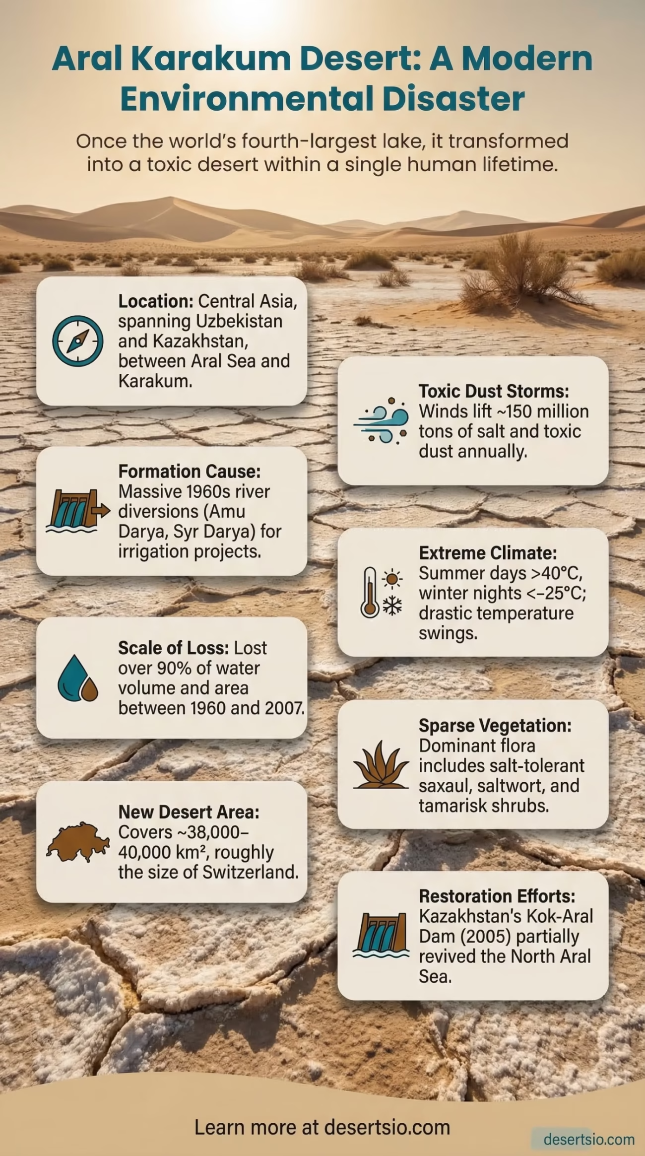
| Location | Central Asia — between the Aral Sea basin and the Karakum Desert, spanning Uzbekistan and Kazakhstan |
| Area | Approximately 38,000–40,000 km² (14,700–15,400 sq mi) — roughly the size of Switzerland |
| Type | Sandy desert / anthropogenic desertification zone |
| Elevation | 53 m below sea level (former Aral Sea bed) to ~200 m above sea level |
| Average Daytime Temperature | Summer: 40–45°C (104–113°F) / Winter: −20 to −25°C (−4 to −13°F) |
| Average Nighttime Temperature | Summer nights: 20–25°C / Winter nights: −25 to −30°C |
| Annual Precipitation | Less than 100 mm/year (under 4 inches) |
| Primary Formation Cause | Diversion of Amu Darya and Syr Darya rivers beginning in the 1960s |
| Salt Crust Composition | Up to 150 million tons of salt and toxic dust deposited annually across the region |
| Water Loss | Aral Sea lost over 90% of its water volume between 1960 and 2007 |
| Dominant Vegetation | Sparse saxaul (Haloxylon), saltwort (Salsola), tamarisk (Tamarix) |
| Human Population | Severely reduced; some remaining communities in Moynaq (Uzbekistan) and Aralsk (Kazakhstan) |
| UNESCO Status | Recognized as one of the world’s worst environmental disasters |
| Current Restoration Efforts | Kok-Aral Dam recovery in the north plus large-scale saxaul and halophyte planting on the dried seabed. Kazakhstan reported 1.1175 million hectares of forest-melioration work during 2021–2025, with another 116,000 hectares added in 2026. |
The Aral Karakum Desert is not a desert in the traditional sense — it was not always there. What exists today is the exposed seabed of what was once the fourth-largest lake in the world, now transformed into one of the most dramatic examples of human-induced desertification ever recorded. Within a single human lifetime, an inland sea evaporated. What remained was salt, dust, and silence.
The term “Aral Karakum” — sometimes written as Aralkum — refers specifically to the newly formed desert that emerged from the dried-out floor of the Aral Sea. Karakum translates roughly as “black sand” in Turkic languages, a name shared with the massive Karakum Desert of Turkmenistan to the south. But the Aral Karakum is its own distinct phenomenon: younger, saltier, and far more toxic than its neighbor.
Aral Karakum Desert Location and Map View
Formation: How a Sea Became a Desert
The Aral Sea once covered around 68,000 km² — an enormous body of water fed by two major rivers, the Amu Darya (flowing from Tajikistan and Afghanistan) and the Syr Darya (originating in Kyrgyzstan). In the 1960s, large-scale Soviet irrigation projects began diverting these rivers to feed cotton and wheat fields across the Central Asian steppe. The logic was straightforward: maximize agricultural output from arid land.
The consequence was not foreseen — or perhaps not taken seriously enough. With its two main water sources redirected, the Aral Sea began to shrink. Slowly at first. Then rapidly. By the 1980s, satellite images already showed a sea splitting into two separate bodies. By 2007, the lake had lost more than 90% of its volume. The southern basin essentially ceased to exist as a functioning lake.
What was exposed beneath the retreating water was a flat, mineral-rich lakebed — now baked by extreme heat, scoured by wind, and encrusted with salt. This is the Aral Karakum: a desert formed not by geological time but by decades of engineering decisions. It is one of the youngest deserts on Earth.
How Big Is It — And What Does That Actually Mean?
The Aral Karakum currently covers approximately 38,000–40,000 km². To put that in perspective, it is roughly the size of Switzerland — or larger than the entire country of the Netherlands and Belgium combined. And it did not exist before 1960. That scale of land transformation within a few decades is almost without parallel in modern environmental history.
Unlike ancient deserts formed over millennia, this one grew within living memory. Fishermen who worked the Aral Sea as children watched it disappear during their own lifetimes. Former port towns like Moynaq in Uzbekistan and Aralsk in Kazakhstan — once thriving fishing communities — found themselves stranded dozens of kilometers from any water.
Temperature: A Desert of Extremes
The climate of the Aral Karakum is brutally continental. There is no moderating water body anymore — the lake that once softened temperature swings is gone. Summer daytime temperatures regularly exceed 40–45°C (104–113°F), while winter nights can plummet to −25 to −30°C (−13 to −22°F). The diurnal (day-night) range in summer alone can reach 20–25°C, dropping from scorching afternoon heat to surprisingly cool, almost cold nights.
Annual precipitation barely reaches 100 mm/year — less than London gets in an average month. Wind is a defining feature of the landscape. Dust storms carrying salt and pesticide residues from the former lakebed are common, sometimes traveling hundreds of kilometers before depositing their toxic load.
The Salt Dust Problem
The Aral Karakum is not just a sandy desert. Its surface is heavily contaminated with salt, pesticides, and heavy metals — residues from decades of Soviet-era agricultural runoff that accumulated on the lakebed. Winds lift an estimated 150 million tons of salt and toxic dust per year, creating a regional public health crisis. Communities across Uzbekistan and Kazakhstan report elevated rates of respiratory illness, anemia, and kidney disease. The dust has been detected as far as the Himalayan glaciers and Arctic ice cores.
Flora and Fauna: Life in an Unlikely Place
Survival here demands adaptation at an extreme level. The Aral Karakum is not completely barren — nature, as it tends to do, finds a way. But what grows and lives here is sparse, specialized, and often salt-tolerant to a remarkable degree.
Dominant plant species include:
- Saxaul (Haloxylon ammodendron) — a deep-rooted, drought-hardy tree critical for stabilizing sand and salt crusts
- Saltwort (Salsola spp.) — one of the first colonizers on exposed lakebed, tolerating extreme salinity
- Tamarisk (Tamarix spp.) — a shrub that can excrete salt through its leaves, thriving where most plants collapse
- Kalidium and Suaeda species — halophytic plants found along the saltiest zones of the former shoreline
Fauna is thin but present. Saiga antelopes — a critically endangered species native to Central Asian steppes — occasionally move through the edges of the desert. Migratory birds still pass overhead, though they no longer find the wetland habitat they once did. Reptiles, particularly lizards and snakes adapted to dry, saline conditions, have claimed parts of the lakebed as their own. The former sea’s fishery — which once produced 40,000–50,000 tons of fish annually — is, on the southern side, essentially gone.
Human Life: Who Still Lives Here?
The people of the Aral region are among the most resilient — and most overlooked — in Central Asia. Moynaq, once a bustling Uzbek fishing port with a canning industry that exported fish across the Soviet Union, now sits roughly 150 km from the nearest water. The ships that used to dock there are rusting in the desert sand — a graveyard of metal hulls that has become one of Central Asia’s most photographed landscapes.
Population in these communities has declined sharply. Moynaq’s population dropped from roughly 40,000 at its peak to around 5,000–7,000 today. Young people left. Older residents stayed, often with no other option. Those who remain face serious health challenges linked to the salt and dust contamination — healthcare infrastructure in the region is limited, and access to clean water is difficult.
There are no nomadic tribes living within the desert itself. The conditions are simply too hostile. But the Karakalpaks — an indigenous Turkic people — have inhabited the surrounding region for centuries, and their cultural identity is deeply tied to the Aral Sea. Karakalpakstan, an autonomous republic within Uzbekistan, bears the weight of this environmental crisis more than any other area.
The North Aral: A Recovery Story Worth Noting
Not everything here points to decline. In 2005, Kazakhstan completed the Kok-Aral Dam — an 87-km dike built to separate the northern section of the Aral Sea from the southern basin and allow it to refill from the Syr Darya. The results surprised many scientists.
Within a few years, the North Aral Sea’s water level rose by several meters. Salinity dropped. Fish returned. By the early 2010s, commercial fishing had resumed in the north. The town of Aralsk, once left stranded, began to see the water approaching again. It is a partial recovery — the southern basin remains a desert — but it demonstrates that targeted intervention can, at least in some cases, reverse desertification driven by water loss.
North Aral (Kazakhstan)
Kok-Aral Dam built in 2005. Water levels rose 3–4 meters within years. Salinity fell from 40 g/L to below 10 g/L. Fish stocks partially restored. Commercial fishing resumed.
South Aral (Uzbekistan)
Largely dried. No comparable water-body recovery has occurred. The Aral Karakum desert occupies this area. Moynaq remains stranded, while large-scale saxaul and salt-tolerant vegetation planting continues across exposed parts of the former seabed.
Neighboring Deserts: Context Within Central Asia
The Aral Karakum does not sit in geographic isolation. Central Asia is home to several major desert systems, and understanding how they relate to each other helps clarify the scale of aridity across the region.
- Karakum Desert (Turkmenistan) — covering approximately 350,000 km², this is one of the largest sandy deserts in the world. The name is shared but the origin is entirely different — ancient, wind-sculpted, and geologically old. The Aral Karakum is essentially its younger, man-made sibling to the north.
- Kyzylkum Desert — stretching across Uzbekistan and Kazakhstan, this 298,000 km² desert lies directly between the two former Aral Sea rivers. It is ancient and sandy, and its southeastern edge nearly borders the Aral Karakum. The two zones are merging in some areas.
- Ustyurt Plateau — a vast, flat tableland desert between the Aral Sea and the Caspian Sea, characterized by clay and chalk rather than sand. Arid and largely uninhabited.
If you compare the Aral Karakum to other human-influenced desert zones worldwide, the Atacama’s expansion zones in South America or the southern fringe of the Sahara (Sahel region) come to mind. All share desertification driven partly by human activity — but the Aral situation is unusually rapid and partly reversible in the northern basin.
Aral Restoration Update: 2026
Restoration around the former Aral Sea now extends far beyond the 2005 Kok-Aral Dam. Much of the work on the exposed seabed uses saxaul and other salt-tolerant plants to anchor loose sediment, reduce wind erosion, and limit the movement of salt-laden and contaminated dust into surrounding areas.
Kazakhstan’s Ministry of Ecology and Natural Resources reported in 2026 that forest-melioration work on the country’s dried Aral seabed had covered 1.1175 million hectares during 2021–2025, with a further 116,000 hectares added in 2026. Across the program, forestry teams had sown 3,440.9 tonnes of saxaul and halophyte seed and planted 53.2 million saxaul seedlings.
Saxaul is suited to this job because its root system binds loose desert soil and helps reduce surface movement in strong winds. The objective is not to recreate the former sea with trees. It is to stabilize exposed ground, establish plant cover where conditions allow it, and reduce the amount of contaminated sediment that can be lifted from the old lakebed.
Kazalinsk Nursery and New Saxaul Capacity
Another part of the restoration system is the 33.5-hectare forest nursery in Kazalinsk District, built during 2023–2024. Its annual production capacity is about 3 million black saxaul seedlings, along with approximately 55,000 seedlings of hardwood and fruit-bearing species.
The World Bank reported in March 2026 that more than 74,000 hectares of the dried Aral seabed had been planted or seeded with saxaul and other salt-tolerant shrubs during 2023–2024. These plantings help stabilize sandy surfaces and reduce the spread of toxic dust rather than relying on exposed sediment to remain naturally fixed.
Uzbekistan is carrying out large-scale planting on its side of the former lakebed as well. By 2023, government figures reported saxaul planting across more than 1.7 million hectares of exposed seabed. Taken together, these projects show how vegetation stabilization has become one of the main practical responses to the expanding dry lakebed.
Regional Water Management Moves Into a New Phase
Planting the exposed seabed addresses dust and soil movement, but the Aral system also depends on how water is managed throughout the Amu Darya and Syr Darya basins. On July 21, 2026, the World Bank approved a US$20 million grant for the Central Asia Water Efficiency Cooperation Project (CAWEC), to be implemented through the Executive Committee of the International Fund for Saving the Aral Sea.
- Shared water management: the project covers cooperation across the Amu Darya and Syr Darya river basins.
- Digital water accounting: regional information and water-accounting systems are scheduled for modernization.
- Future infrastructure: the project is intended to prepare up to six transboundary water infrastructure projects by 2031.
- Water conservation: planned work includes irrigation modernization, storage, conservation, and coordinated operation of shared water resources.
These water-management measures operate at a different scale from saxaul planting, yet both affect the Aral region. Vegetation can stabilize land that has already emerged, while river-basin management determines how efficiently the remaining and incoming water is used.
The Aral Karakum is also becoming — strangely — a subject of scientific interest for researchers studying rapid ecosystem formation. A desert that formed in 50 years gives scientists a rare window into how plant communities establish themselves on bare, hostile substrates. What colonizes first? How does soil chemistry change? The answers have implications far beyond Central Asia.
Desert Glossary: Key Terms
Aralkum — The scientific/geographic name used for the Aral Karakum Desert, referring specifically to the exposed lakebed of the former Aral Sea.
Halophyte — A plant adapted to grow in saline, salt-heavy soils; the dominant vegetation type across the Aral Karakum.
Anthropogenic Desertification — Desert formation caused by human activity rather than natural climate shifts; the defining characteristic of the Aral Karakum.
Diurnal Range — The difference between daytime high and nighttime low temperatures; extreme in the Aral Karakum due to the loss of the sea’s moderating effect.
Technical Data: What the Numbers Show
| Aral Sea Area (1960) | ~68,000 km² |
| Aral Sea Area (2007) | ~10,000 km² (south basin: ~2,000 km²) |
| Water Volume Lost | Over 1,000 km³ — more than 90% of original volume |
| Salinity Increase | From ~10 g/L (1960) to over 100 g/L (2000s, south basin) |
| New Desert Area Formed | ~38,000–40,000 km² (Aral Karakum) |
| Annual Dust/Salt Emission | ~150 million tons per year |
| Saxaul Planted (Uzbekistan) | Over 1.7 million hectares by 2023 |
| Kazakhstan Dried-Seabed Forest Work (2021–2025) | 1.1175 million hectares |
| Additional Kazakhstan Area in 2026 | 116,000 hectares |
| Saxaul and Halophyte Seed Sown | 3,440.9 tonnes reported in 2026 |
| Saxaul Seedlings Planted | 53.2 million reported in 2026 |
| Kazalinsk Nursery Capacity | 3 million black saxaul seedlings per year |
| Aral Seabed Planted or Seeded (2023–2024) | More than 74,000 hectares reported by the World Bank |
| CAWEC Regional Water Project | US$20 million grant approved July 21, 2026 |
| North Aral Salinity (post-dam) | Dropped from ~40 g/L to below 10 g/L |
| North Aral Water Level Rise | +3–4 meters above pre-dam level |
| Former Annual Fish Catch | 40,000–50,000 tons/year (pre-1960s) |
These figures record a rapid environmental shift that reshaped regional hydrology, exposed tens of thousands of square kilometers of former seabed, and created new land-management problems within a few decades. The restoration data from 2026 also show that work in the Aral region now combines surface stabilization, nursery production, revegetation, and basin-wide water management.
The North Aral continues to show what controlled water management can achieve in part of the basin, while the exposed seabed requires a different response. Saxaul planting, salt-tolerant vegetation, nursery expansion, soil stabilization, and coordinated management of the Amu Darya and Syr Darya now form the main practical lines of work across the wider Aral region.