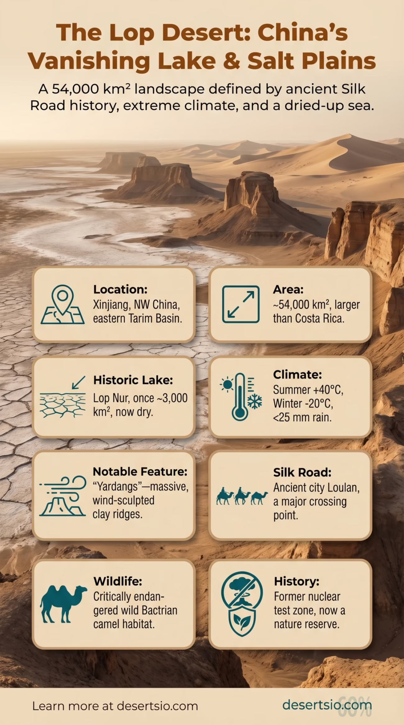
| Location | Xinjiang Uyghur Autonomous Region, Northwestern China |
| Total Area | Approximately 54,000 km² (20,800 sq mi) |
| Type | Salt desert / Sandy desert (combined) |
| Elevation | 780–800 m (2,560–2,625 ft) above sea level |
| Daytime Temperature | Up to +40°C (104°F) in summer |
| Nighttime Temperature | Down to −20°C (−4°F) in winter |
| Annual Precipitation | Less than 25 mm (1 inch) |
| Primary River Inputs | Tarim River, Konqi River |
| Adjacent Desert | Taklamakan Desert (northwest border) |
| Historic Lake | Lop Nur — a former saltwater lake, now dried |
| Coordinates | ~40°N, 90°E |
| Notable Feature | Site of the ancient Silk Road crossing; former nuclear test zone |
At the eastern edge of the Tarim Basin, where the Silk Road once threaded its way through one of Asia’s most forbidding landscapes, the Lop Desert stretches across roughly 54,000 square kilometers of salt flats, wind-sculpted clay, and shifting sand. It’s a place that erases things — ancient cities, rivers, even a lake that once covered over 3,000 km².
- Lop Desert: Location and Map View
- How Big Is the Lop Desert?
- Formation: How the Lop Desert Came to Be
- Lop Nur: The Vanishing Lake
- Temperature: Extremes in Every Direction
- Flora and Fauna: What Survives Here
- The Silk Road Connection
- Human Life in the Lop Region
- Neighboring Deserts and Regional Context
- Yardangs: The Lop Desert’s Strangest Landform
- The Lop Desert Today: Conservation and Environmental Pressures
- A Desert That Holds Its Secrets Well
The Lop Desert is not simply sand. It’s a layered record of geological change, human ambition, and ecological collapse — all compressed into one of the driest corners of Central Asia.
Lop Desert: Location and Map View
How Big Is the Lop Desert?
At approximately 54,000 km², the Lop Desert is roughly the size of Croatia — or, to put it another way, larger than the entire country of Costa Rica. When you include the broader Lop Nur basin and the surrounding salt plains, the total desolate area expands considerably. It sits at the eastern terminus of the Tarim Basin, flanked to the northwest by the Taklamakan Desert, which itself is one of the largest sandy deserts on Earth (approximately 337,000 km²).
Together, these two form an almost uninterrupted arid zone across Xinjiang. The Lop Desert functions, in a sense, as the Taklamakan’s eastern exhaust — the endpoint where rivers dry out, sediment accumulates, and wind carries the final remnants of whatever was once wet.
Formation: How the Lop Desert Came to Be
The Lop Desert did not form overnight. It is the product of tectonic uplift, climatic drying, and river migration playing out over millions of years.
During the Pleistocene epoch (roughly 2.6 million to 11,700 years ago), the Tarim Basin held extensive freshwater systems. Rivers flowing from the surrounding mountain ranges — the Kunlun, Tian Shan, and Altyn-Tagh — fed a large inland lake system centered around what is now the Lop Nur basin. As the Himalayas and Tibetan Plateau rose, they created a massive rain shadow, cutting off moisture from the Indian Ocean. Precipitation dropped. Rivers shrank.
The Tarim River, historically the primary feeder of Lop Nur, gradually shifted its course — sometimes north, sometimes south — a phenomenon that 20th-century geographers called the “wandering lake” problem. Each migration of the river left behind a different salt flat configuration. By the mid-20th century, the combination of natural drying and upstream agricultural water diversion had reduced Lop Nur to a dry salt crust.
What remains today is a desert built from the bones of a lake.
Lop Nur: The Vanishing Lake
Lop Nur is arguably the most geographically significant feature of the Lop Desert. At its maximum extent (estimated at around 3,000 km² in the early 20th century), it was a shallow, brackish lake fed by the Tarim and Konqi rivers. Satellite imagery from the 1970s onward revealed something striking: the dried lakebed displays a series of concentric, ear-shaped rings caused by successive shorelines as the lake shrank. This gave Lop Nur its well-known nickname — “The Ear of China.”
By 1972, the lake had essentially disappeared. The upstream diversion of the Tarim River for cotton irrigation in the 1950s–1960s accelerated what was already a long natural process. Today, the lakebed is a gleaming white salt flat — saline, cracked, and almost entirely lifeless.
Lop Nur Water Loss — Key Data Points
- Early 1900s lake area: ~3,000 km²
- By 1950: Reduced to approximately 500 km²
- By 1972: Completely dry — confirmed by Landsat satellite data
- Primary cause: Upstream water diversion for agriculture (Tarim River)
- Salt crust thickness today: Estimated 2–10 cm in most areas
Temperature: Extremes in Every Direction
The Lop Desert operates on brutal thermal cycles. Summers are scorching — daytime temperatures regularly exceed 40°C (104°F), and the salt flats radiate heat with an intensity that makes the air above them shimmer like liquid glass. Winters flip the script entirely.
Winter nights can plunge to −20°C (−4°F), a swing of more than 60°C from peak summer days. That’s not unusual for a continental desert at this latitude, but it’s still worth emphasizing: the same ground that bakes in July freezes solid by December. Annual precipitation is almost nonexistent — consistently below 25 mm per year, with some years recording virtually zero.
Wind is the other force shaping this landscape. Strong northwest winds, known locally as karaburan (a Uyghur term meaning “black storm”), drive massive dust and sand events across the basin. These storms can reduce visibility to near zero and carry fine particulate matter hundreds of kilometers away.
Flora and Fauna: What Survives Here
Survival in the Lop Desert demands extreme adaptation. The landscape is harsh — but not entirely empty.
Plant life clings to the margins. Along the edges of dried riverbeds and slightly less saline zones, you can find:
- Tamarix (tamarisk shrubs) — incredibly salt-tolerant, they form dense thickets called tugai, a Central Asian riparian woodland type unique to arid river corridors
- Haloxylon ammodendron (saxaul tree) — a slow-growing desert tree with near-zero water needs, critical for stabilizing desert soil
- Phragmites australis (common reed) — found in remnant moisture zones near former river channels
- Various salt-tolerant succulents and ephemeral annuals that germinate only after rare rainfall events
Fauna is sparse but real. The Bactrian camel (Camelus ferus) — the wild, two-humped variety — is critically endangered globally, with fewer than 1,000 individuals estimated in the wild. A significant portion of the remaining population inhabits the Lop Nur Nature Reserve, established in 1986. Other recorded species include the Tibetan gazelle, various raptors, sand lizards, and migratory bird species that use the occasional water remnants as stopover points.
And the wild Bactrian camel is genuinely wild — not feral. That distinction matters for conservation biology.
The Silk Road Connection
For over a millennium, the Lop Desert served as a critical — if terrifying — waypoint on the Silk Road. Ancient merchants traveling between China and the West had to cross or skirt this desert, and the town of Loulan (also written as Kroran) served as the primary rest stop.
Loulan flourished between approximately the 2nd century BCE and the 4th century CE. Archaeological excavations have uncovered wooden structures, silk fragments, documents written in Kharosthi script, and remarkably preserved human remains — the so-called “Loulan Beauty,” a mummy estimated to be over 3,800 years old with striking physical features. The site was rediscovered in 1900 by Swedish explorer Sven Hedin and later excavated by Aurel Stein.
The city was abandoned, likely due to the shifting course of the Tarim River cutting off its water supply — a haunting historical parallel to the modern drying of Lop Nur itself.
Human Life in the Lop Region
The interior of the Lop Desert is, for all practical purposes, uninhabited. The salt flat environment of the former Lop Nur lakebed offers nothing — no freshwater, no arable soil, no shelter from wind or temperature extremes.
On the periphery, the story is different. The Loplyk (or Lop people) — a small Uyghur subgroup — historically inhabited the reed marshes and river delta areas around Lop Nur. They fished, hunted waterfowl, and lived almost entirely off the ecosystem of the lake and its surrounding wetlands. As the lake dried, so did their traditional way of life. By the mid-20th century, the Loplyk had largely integrated into broader sedentary Uyghur communities in nearby towns such as Ruoqiang (Charchan) and Miran.
Today, the main population centers near the Lop Desert are agricultural oasis towns sustained by irrigation from remaining Tarim River water allocations. The Tarim River Basin supports roughly 10 million people across Xinjiang, most of them concentrated in oasis cities well north and west of the Lop Desert itself.
Neighboring Deserts and Regional Context
The Lop Desert doesn’t exist in isolation. It sits within one of the most concentrated arid zones on the planet.
| Desert | Location | Area (km²) | Relation to Lop |
| Taklamakan Desert | Xinjiang, China | ~337,000 | Directly adjacent (northwest) |
| Gobi Desert | Mongolia / N. China | ~1,300,000 | Northeast continuation of the arid zone |
| Gashun Gobi | Gansu / Inner Mongolia | ~60,000 | Eastern neighbor, similar salt-flat terrain |
| Kumtag Desert | Gansu / Xinjiang border | ~22,800 | Southeast, shares dust storm dynamics |
The Taklamakan is the most relevant comparison. Both are closed-basin deserts within the Tarim system, both shaped by rain shadow effects from surrounding mountain ranges, and both experience the same brutal karaburan storms. The key difference? The Taklamakan is dominated by massive linear sand dunes (some exceeding 200 m in height), while the Lop Desert is primarily salt flat and yardang terrain — wind-eroded ridges of hardened clay that can rise 20–30 meters above the desert floor like the prows of half-buried ships.
The Gobi Desert, stretching northeast, shares the Lop Desert’s continental climate extremes but differs geologically — the Gobi is largely rocky (a “gravel desert” or reg) rather than salt-dominated.
Yardangs: The Lop Desert’s Strangest Landform
If there’s one feature that sets the Lop Desert apart visually, it’s the yardangs. These wind-sculpted landforms — elongated ridges of compressed clay and silt, aligned parallel to prevailing winds — dominate large sections of the desert floor.
The Lop Desert contains some of the largest and best-developed yardang fields on Earth. Individual ridges can stretch for kilometers in length, and the spacing between them creates narrow corridors that amplify wind speed — producing an eerie, low howling that ancient travelers interpreted as supernatural. Marco Polo, passing through this general region in the 13th century, described “strange and desolate sounds” emanating from the desert, almost certainly a description of wind moving through yardang corridors.
Yardang Formation — How It Works
- Wind erodes softer sediment layers faster than harder ones
- Harder clay ridges remain, forming parallel elongated mounds
- Alignment tracks dominant wind direction (NW in the Lop Desert)
- Heights typically range from 5 to 30 meters in the Lop region
- Corridors between ridges become natural wind tunnels, increasing erosion rates
The Lop Desert Today: Conservation and Environmental Pressures
In recent decades, the Lop Desert region has attracted renewed scientific attention — partly for its paleoclimate record, partly for its conservation value, and partly because its environmental fate is a direct mirror of broader challenges facing Central Asian dryland ecosystems.
The Lop Nur Wild Camel National Nature Reserve, covering approximately 61,000 km² (making it one of the largest nature reserves in China), was upgraded to national status in 2003. Its primary goal is protecting the wild Bactrian camel population, which faces pressure from habitat loss, water scarcity, and competition with domestic livestock on the reserve’s margins.
Desertification is another pressing concern. The Tarim River — the lifeblood of the entire basin — has seen its lower reaches repeatedly dry up due to upstream agricultural demand. Since 2000, the Chinese government has implemented a series of ecological water delivery programs, artificially releasing water down the lower Tarim to restore riparian vegetation. By 2022, these programs had delivered over 21 billion cubic meters of water to the lower river system — with measurable recovery in tugai vegetation corridors observed via satellite.
It’s a slow process. But the data suggests it’s working, at least partially.
Meanwhile, dust storms originating in the Lop and Taklamakan regions continue to affect air quality across East Asia. Studies have linked Tarim Basin dust events to particulate matter detected as far east as Japan and Korea — and, under the right atmospheric conditions, across the Pacific. The Lop Desert is not a remote problem. It’s a regional one.
A Desert That Holds Its Secrets Well
The Lop Desert remains one of the least-visited and least-studied desert environments on Earth — partly due to its remoteness, partly due to restricted access in certain zones. Archaeological surveys continue to uncover new sites in the broader Tarim Basin, each one adding detail to our understanding of Bronze Age and early Iron Age populations who somehow managed to live beside this landscape.
What the Lop Desert offers, beyond its scientific value, is a kind of geographic honesty. It doesn’t pretend to be hospitable. The salt is white and hard. The yardangs are jagged. The wind moves constantly. And somewhere beneath the crust of the old lakebed, the sediment layers hold a climate record stretching back hundreds of thousands of years — still largely unread.
Some deserts are defined by their sand. The Lop Desert is defined by its absence — of water, of soft edges, of anything that could be called gentle.
