| Location | Southeastern Iran (Kerman, Sistan-Baluchestan, South Khorasan provinces) |
| Area | Approximately 51,800 km² (20,000 sq mi) |
| Desert Type | Hot desert (hyperarid) |
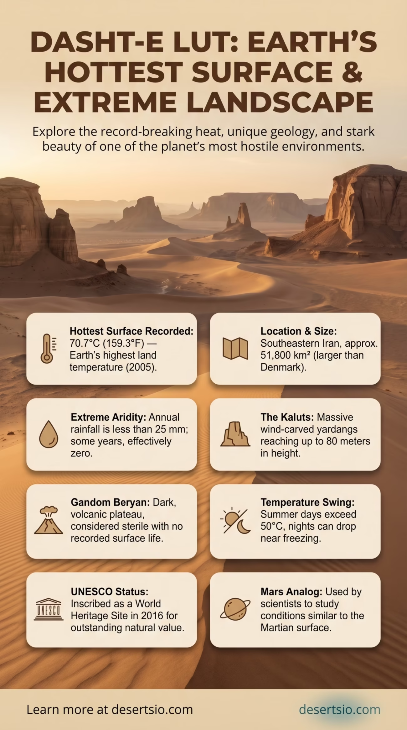
| Highest Recorded Surface Temperature | 70.7°C (159.3°F) — hottest land surface ever recorded on Earth (2005) |
| Average Summer Air Temperature | Up to 50°C (122°F) during the day |
| Average Winter Temperature | Around 0°C to 5°C at night |
| Annual Rainfall | Less than 25 mm per year |
| Elevation | Ranges from 300 m to over 1,000 m above sea level |
| UNESCO Status | World Heritage Site (inscribed 2016) |
| Dominant Features | Kaluts (yardangs), salt flats, sand dunes, lava fields |
| Nearest Major City | Kerman (~300 km west) |
| Drainage | Endorheic basin — no rivers flow out |
Dasht-e Lut — literally “Plain of Emptiness” in Persian — holds a record no other place on Earth can claim: the hottest surface temperature ever measured anywhere on the planet. In 2005, NASA’s MODIS satellite detected a land surface temperature of 70.7°C (159.3°F) across the Gandom Beryan plateau within this desert. That single data point reshaped how scientists think about planetary heat limits. And yet, this extreme landscape is far more layered than a single number suggests.
- Dasht-e Lut Desert: Location and Map View
- How Big Is Dasht-e Lut?
- Formation: How This Desert Came to Be
- The Kaluts: Lut’s Signature Landscape
- Temperature: Daytime Inferno, Cold Nights
- Flora and Fauna: Life at the Edge
- Human Life in and Around the Desert
- UNESCO Recognition and Scientific Significance
- Comparable Deserts and Regional Neighbors
- Climate Change and the Future of Lut
Dasht-e Lut Desert: Location and Map View
How Big Is Dasht-e Lut?
The desert spans roughly 51,800 km² across southeastern Iran — an area larger than the entire country of Denmark (43,094 km²) and nearly the size of Costa Rica. Stretched across three Iranian provinces (Kerman, Sistan-Baluchestan, and South Khorasan), Dasht-e Lut forms one of the most geographically isolated interior basins in Southwest Asia.
Within it, a dark, volcanic plateau called Gandom Beryan — meaning “scorched wheat” in the local dialect — covers around 480 km² and is entirely devoid of life. Even bacteria struggle to survive there. It is not just a desert; it is arguably the most hostile terrain on the surface of this planet.
Formation: How This Desert Came to Be
Dasht-e Lut occupies a large tectonic depression — a basin formed through the movement and collision of the Arabian and Eurasian plates over millions of years. As the surrounding mountain ranges rose (particularly the Zagros and Makran mountains to the west and south), they created an effective rain shadow. Moisture-carrying winds from the Indian Ocean are blocked before they ever reach the interior.
The result is a classic rain shadow desert, reinforced by distance from any ocean moisture source. Geological evidence suggests the basin has been hyperarid for at least several hundred thousand years, though the landscape itself continues to shift — driven by wind erosion, salt deposition, and episodic flash flooding from distant mountain ranges.
Lava fields visible today indicate past volcanic activity, adding another dimension to its already striking geology. The dark basaltic rock of Gandom Beryan absorbs solar radiation with unusual efficiency — a key reason why surface temperatures there exceed even the Sahara or the Arabian Desert on the hottest days.
The Kaluts: Lut’s Signature Landscape
Perhaps no geological feature defines Dasht-e Lut more visually than its kaluts — towering yardangs sculpted entirely by wind. These are not small formations. Some reach 75–80 meters in height and extend across hundreds of square kilometers in the western portion of the desert. The word “yardang” itself comes from the Turkic/Persian tradition of describing these wind-carved ridges.
Yardangs form when strong, prevailing winds erode softer sediment over thousands of years, leaving behind hardened ridges aligned parallel to the dominant wind direction. In Lut, the wind pattern is remarkably consistent — flowing from the north-northwest, shaping the kaluts into long, whale-back forms. From above, they look like a city carved from sand and clay. From the ground, they feel like something else entirely.
Temperature: Daytime Inferno, Cold Nights
The thermal extremes here are not just record-breaking — they are scientifically significant. The air temperature regularly exceeds 50°C (122°F) in summer, while land surface temperatures measured by satellite consistently reach 65–70°C in the Gandom Beryan region between June and August.
Seasonal Temperature Range Overview:
- Summer daytime air temp: 45–50°C (113–122°F)
- Peak surface temperature (recorded): 70.7°C (159.3°F) — June 2005
- Winter nighttime temp: 0°C to –5°C in elevated areas
- Day-night swing (summer): Can exceed 30°C within 12 hours
- Annual precipitation: Below 25 mm — some years, effectively zero
That swing — from scorching noon to near-freezing midnight — is a hallmark of continental hyperarid deserts. The atmosphere is too dry to retain heat overnight. Desert travellers and researchers who have worked in Lut describe the nights as startlingly cold given what the afternoon felt like. The same ground that burns at 70°C by afternoon can drop below 15°C by dawn.
Flora and Fauna: Life at the Edge
Most of Dasht-e Lut is biologically barren. Gandom Beryan, in particular, contains no recorded plant or animal life — a genuinely sterile environment. But the desert as a whole is not entirely lifeless.
On the peripheral margins and in areas where seasonal water movement is possible, a limited but resilient ecology takes hold:
- Plants: Hardy shrubs such as Calligonum (a saxaul-relative), tamarisk (Tamarix spp.), and scattered desert grasses appear near the edges where groundwater occasionally surfaces.
- Mammals: Persian gazelle (Gazella subgutturosa), cape hare, and sand foxes have been documented in transitional zones.
- Reptiles: Several species of lizard — particularly monitor lizards (Varanus griseus) and agamids — thrive in the drier zones.
- Birds: Raptors including eagles and falcons patrol the margins. During migration periods, some species pass through the fringes.
- Insects and arachnids: Scorpions and various beetle species have been found even in relatively hot zones — their thermal tolerance is remarkable.
And there’s one more thing worth mentioning: carrion beetles were discovered living on the surface of Gandom Beryan — surviving not on local vegetation, but on organic matter blown in by wind from the outer desert. Life, it seems, finds a workaround.
Human Life in and Around the Desert
The core of Dasht-e Lut is, by any reasonable measure, uninhabitable. Yet humans have navigated around and through it for millennia.
Ancient trade routes — extensions of the Silk Road network — historically skirted the edges of Lut, connecting the city of Kerman to Zahedan and eastward into present-day Pakistan. Caravanserais (roadside rest structures) still stand at intervals along these old paths, their mud-brick walls half-dissolved by wind and time.
Small settlements exist on the desert’s margins, primarily communities involved in date palm cultivation and small-scale herding. The Baluch people — a semi-nomadic ethnic group spread across southeastern Iran, southwestern Pakistan, and southern Afghanistan — have historically used the desert’s edges for seasonal grazing. Their deep familiarity with this landscape, built over centuries, is itself a form of indigenous ecological knowledge.
Today, the nearest significant urban center is Kerman to the west (~300 km). The desert itself draws a modest but growing stream of scientific expeditions and adventurous travellers — especially since its UNESCO World Heritage designation in 2016.
UNESCO Recognition and Scientific Significance
In July 2016, Dasht-e Lut was inscribed on the UNESCO World Heritage List — one of the few desert landscapes in the world to receive this designation. The inscription criteria cited its outstanding natural values, including its exceptional geological record, its extreme physical processes, and the sheer scale of its aeolian (wind-formed) features.
For planetary scientists, Lut is also a proxy environment for studying Mars. The combination of extreme dryness, high UV radiation, extreme thermal cycling, and low biological activity makes it one of the most Mars-analogous places on Earth. Research conducted here has direct implications for understanding whether life could persist — or once persisted — in similarly hostile conditions elsewhere in the solar system.
Comparable Deserts and Regional Neighbors
Dasht-e Lut sits within a broader belt of arid landscapes that dominate the Iranian Plateau and surrounding regions. Its closest geographic neighbor is Dasht-e Kavir (the Great Salt Desert), located roughly 300 km to the northwest. Kavir is larger — approximately 77,000 km² — and is characterized primarily by salt flats and mudflats rather than the dramatic yardang fields of Lut. The two deserts together cover a massive portion of Iran’s interior and are often discussed in tandem by geographers.
Further east, the Registan Desert in Afghanistan shares some visual and geological similarities — particularly its vast sand dune systems. And to the south, the Makran coastal desert stretches along the Arabian Sea coast through both Iran and Pakistan, though it differs significantly in humidity and ecology.
| Desert | Country | Area (km²) | Key Feature |
| Dasht-e Lut | Iran | ~51,800 | Hottest surface on Earth, kaluts (yardangs) |
| Dasht-e Kavir | Iran | ~77,000 | Vast salt flats, mudflats, crusted surface |
| Registan | Afghanistan | ~146,000 | Large sand dune systems |
| Thar Desert | India/Pakistan | ~200,000 | Subtropical desert, relatively higher rainfall |
In terms of temperature extremes, Dasht-e Lut’s closest global comparison is the Lut-Sahara overlap zone — though even the Sahara’s highest recorded surface temperature (around 70.5°C in portions of the Saharan interior) is marginally lower than Lut’s peak. The two deserts are broadly similar in type but vastly different in scale: the Sahara is roughly 9 million km², making Lut tiny in comparison — yet in terms of sheer thermal intensity per square kilometer, Lut stands apart.
Climate Change and the Future of Lut
Dasht-e Lut is already at the extreme end of what Earth’s climate produces. So what happens as global temperatures rise?
Researchers monitoring the region have noted several trends. Dust storm frequency has increased across the broader Iranian plateau over the past two decades — a pattern consistent with drying trends documented across the Middle East and Central Asia. Groundwater levels in the marginal settlements around Lut are declining. And the transition zones between the desert and surrounding semi-arid land are contracting.
The IPCC’s assessments on dryland expansion suggest that regions like the Iranian Plateau face a measurably higher risk of intensified aridity through the 21st century. For communities already living on the margins of Dasht-e Lut, that trajectory carries real consequences — shrinking agricultural zones, declining water availability, and increasing pressure on already fragile ecosystems.
The desert itself, of course, has seen far more dramatic shifts over geological time. It will adapt. The question is whether the human and biological communities on its edges can do the same.
Key Facts Worth Knowing:
- Dasht-e Lut holds the highest land surface temperature ever recorded — 70.7°C in 2005, confirmed by NASA MODIS satellite data.
- The desert covers an area larger than Denmark and was designated a UNESCO World Heritage Site in 2016.
- Its Gandom Beryan plateau is considered completely sterile — one of the very few places on Earth with no recorded life on the surface.
- Annual rainfall is less than 25 mm — some years, none at all.
- Scientists use it as an analog environment for Mars research.
