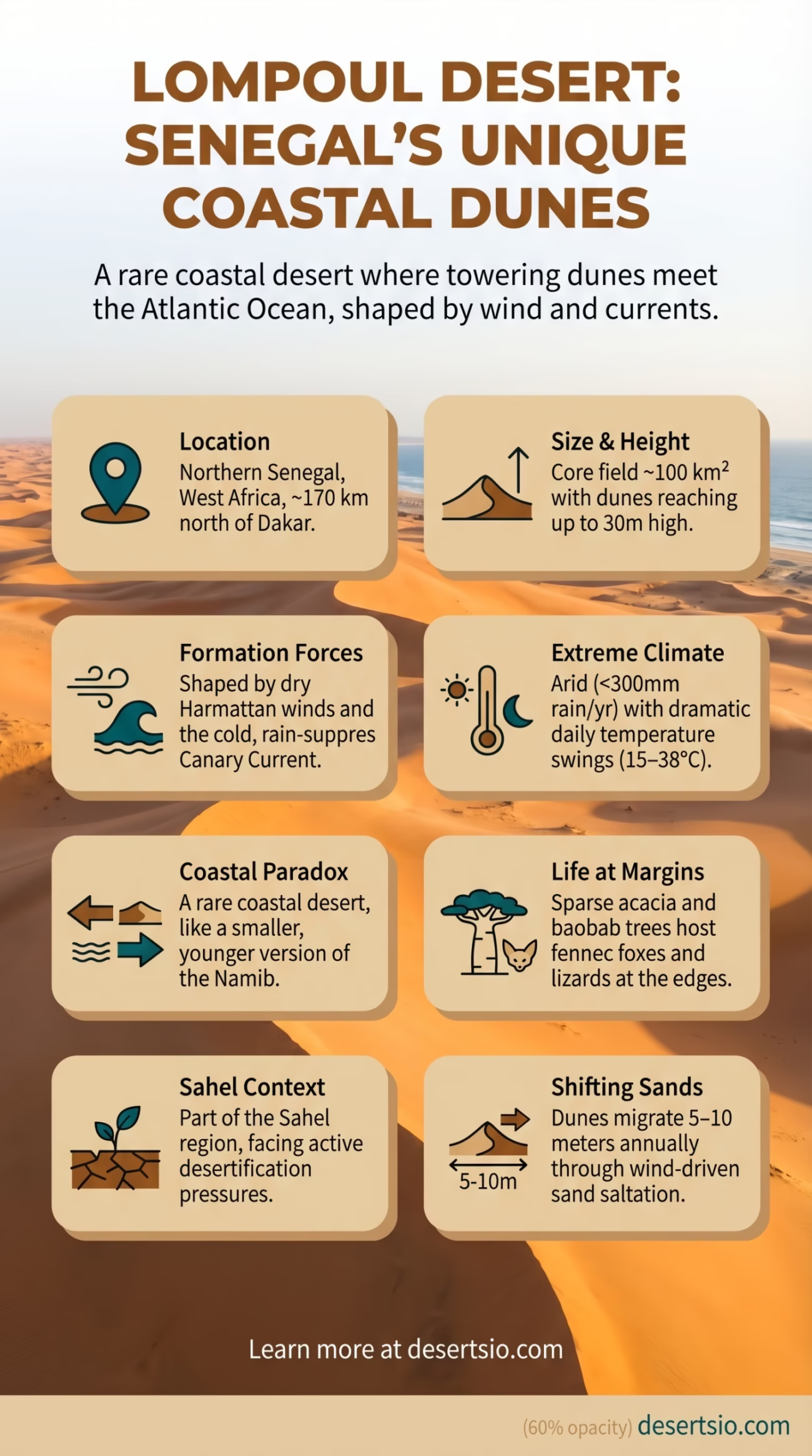
| Location | Northern Senegal, West Africa (near the Atlantic Coast) |
| Area | Approximately 100 km² of core dune field |
| Type | Sandy desert (erg) / semi-arid dune landscape |
| Dune Height | Up to 30 meters (some sources indicate peaks near 25–30 m) |
| Nearest City | Louga (~60 km southeast); Saint-Louis (~100 km north) |
| Average Daytime Temperature | 28–38°C (82–100°F) in dry season |
| Average Nighttime Temperature | 15–20°C (59–68°F) — a significant drop of up to 20°C |
| Annual Rainfall | Less than 300 mm per year |
| Wind System | Harmattan (dry northeastern trade wind from the Sahara) |
| Dominant Vegetation | Sparse acacia scrub, baobab trees at margins |
| Proximity to Sahara | Southern fringe of the Sahara’s Atlantic extension |
| Accessibility | ~170 km north of Dakar via RN 2 highway |
The Lompoul Desert sits roughly 170 kilometers north of Dakar — and yet most people outside West Africa have never heard of it. That gap between obscurity and reality is striking. This is a fully formed sandy desert, complete with towering orange dunes, bone-dry winds, and temperature swings that catch visitors completely off guard. It occupies a narrow but dramatic stretch of northern Senegal, wedged between the Atlantic coastline and the expanding southern edge of the Sahara Desert.
- Lompoul Desert: Location and Map View
- How Big Is the Lompoul Desert?
- Formation: Why Does a Desert Exist Here?
- Temperature: The Day-Night Divide
- Flora and Fauna: What Actually Lives Here
- Human Life: Who Lives in and Around Lompoul?
- Desertification in the Sahel: A Real and Ongoing Crisis
- Lompoul vs. the Namib: A Surprising Parallel
- Nearby Deserts and Arid Landscapes
- The Sahara Desert
- The Mauritanian Sahara
- The Ferlo Desert (Senegal)
- The Sand Science: What Makes Lompoul’s Dunes Move?
- Lompoul in the Context of Climate Data
- Why Lompoul Is Scientifically Interesting
What makes Lompoul unusual — genuinely unusual — is its geographic contradiction. It sits just kilometers from the Atlantic Ocean, yet the landscape is pure desert. The ocean is right there, and still the land bakes.
Lompoul Desert: Location and Map View
How Big Is the Lompoul Desert?
The core dune field of Lompoul covers roughly 100 square kilometers. That’s small by Saharan standards — the Sahara itself spans over 9 million km², making Lompoul about 0.001% of its size. A more relatable comparison: Lompoul’s dune area is approximately the size of the island of Manhattan, New York. Compact, concentrated, and intense.
But size can be misleading here. The dunes themselves rise up to 30 meters high, which is tall enough to disorient anyone standing at the base. The sand is fine-grained, iron-rich, and ranges from pale cream near the surface to deep amber at depth — the color shifts depending on moisture levels and the angle of light. In the late afternoon, the whole field turns a burnt sienna that photographers chase from around the world.
Formation: Why Does a Desert Exist Here?
Lompoul’s existence is a product of two competing forces that, paradoxically, both drive aridity. First: the Harmattan wind. This dry, dust-laden northeastern trade wind blows off the Sahara for much of the year, carrying low-humidity air toward the Atlantic. It suppresses moisture, desiccates soil, and carries fine sand particles that accumulate over millennia.
Second: the Canary Current. Cold Atlantic waters running along Senegal’s coast actually prevent significant rainfall inland. Cold ocean surfaces reduce evaporation, which means fewer clouds and less precipitation reaching the northern Senegalese interior. The result is a coastal desert effect — similar in mechanism to the Namib Desert in southern Africa, where cold Benguela Current waters perform the same role.
Over thousands of years, wind-transported sediment from the broader Saharan system accumulated in this low-lying area. The dunes at Lompoul are classified as barchan and transverse dunes — forms that develop under consistent, directional wind patterns. They’re not static. They migrate slowly, sometimes by several meters per year, depending on seasonal wind intensity.
Temperature: The Day-Night Divide
Sand holds heat — and releases it fast. That’s the core physics behind Lompoul’s dramatic temperature swings.
During the dry season (November through May), daytime temperatures regularly climb between 28°C and 38°C (82–100°F). By midnight, that same landscape can drop to 15–20°C (59–68°F). A swing of up to 20 degrees Celsius in a single day. Sand has a very low specific heat capacity compared to water or dense soil — it cannot store thermal energy for long, so it radiates it back into the atmosphere quickly after sunset.
The rainy season (July–September) brings higher humidity and slightly moderated temperatures, though rainfall remains well below 300 mm annually. Even in these months, Lompoul stays fundamentally arid — the dunes don’t dissolve; they shift.
Flora and Fauna: What Actually Lives Here
The vegetation at Lompoul is sparse by design. The dune interior supports almost no plant life — the constant sand movement makes root establishment nearly impossible. At the margins, however, the picture changes.
- Acacia trees (particularly Acacia senegal) — drought-resistant, deep-rooted, and capable of fixing nitrogen in depleted soils
- Baobab trees (Adansonia digitata) — the iconic symbol of Senegal, found in clusters around the desert’s edges; can store hundreds of liters of water in their trunks
- Euphorbia and succulent scrub — low-growing, waxy-leafed plants adapted to high UV exposure and minimal moisture
- Grasses (Sahelian type) — thin, seasonal grasses that appear briefly after rain events
Animal life follows a similar pattern: mostly nocturnal, mostly small, mostly at the edges. Desert monitor lizards (Varanus exanthematicus, the savannah monitor) are occasionally spotted. Fennec foxes — Vulpes zerda, those large-eared specialists of sandy terrain — range through this zone of Senegal. Scorpions and a variety of beetles are permanent residents, having evolved to metabolize minimal water. Various migratory bird species pass through the Lompoul corridor during seasonal movements along the West African flyway.
Human Life: Who Lives in and Around Lompoul?
The Lompoul area is part of the Louga Region of Senegal — a largely rural administrative zone with a population density far below Senegal’s national average of around 82 people per km². The communities around the desert are predominantly Wolof-speaking (Wolof being the dominant ethnic group and lingua franca of Senegal), with Pulaar-speaking Fula (Fulani) pastoralists also present in the region.
The Fula — known locally as Peul in Senegal — are traditionally semi-nomadic cattle herders. They move seasonally with their livestock (primarily zebu cattle and goats) in search of pasture and water. This transhumance pattern has existed in the Sahel for centuries and remains active today, though desertification pressure increasingly compresses the available grazing corridors.
Permanent settlement directly within the dune field itself is essentially absent. The village of Lompoul-sur-Mer lies to the west, along the Atlantic coast, while the inland farming communities sit further back from the dunes. These villages rely on millet, sorghum, and groundnuts (peanuts — Senegal is historically one of the world’s largest groundnut producers) as primary agriculture.
Desertification in the Sahel: A Real and Ongoing Crisis
Lompoul doesn’t exist in isolation. It sits at the southern edge of a rapidly changing landscape. The Sahel — the semi-arid belt stretching across Africa from Senegal to Eritrea — has experienced southward expansion of desert conditions over the past several decades. According to data from the United Nations Convention to Combat Desertification (UNCCD), approximately 12 million hectares of productive land are lost annually to desertification globally, with the Sahel among the most affected regions. Senegal’s government has been an active participant in the Great Green Wall initiative — a pan-African project aiming to restore 100 million hectares of degraded land across the Sahel by 2030. As of the mid-2020s, progress has been steady but uneven, with Senegal among the leading contributors in terms of restored land area.
Lompoul vs. the Namib: A Surprising Parallel
Lompoul and the Namib Desert (Namibia, southern Africa) share a formation mechanism that’s worth pausing on. Both are coastal deserts created partly by cold ocean currents suppressing inland rainfall. The Namib — one of the oldest deserts on Earth at roughly 55 million years — operates via the cold Benguela Current; Lompoul operates via the cold Canary Current. Different ocean, same physics.
The Namib dwarfs Lompoul: it stretches over 81,000 km² along some 2,000 km of coastline. Lompoul is far younger geologically and far smaller — but the coastal-desert dynamic is a real and meaningful shared characteristic.
| Feature | Lompoul Desert | Namib Desert |
| Location | Northern Senegal, West Africa | Namibia / Angola, Southern Africa |
| Area | ~100 km² | ~81,000 km² |
| Cold Current Influence | Canary Current (Atlantic) | Benguela Current (Atlantic) |
| Dune Type | Barchan, transverse | Star, linear, transverse |
| Annual Rainfall | <300 mm | <25 mm (hyperarid core) |
| Age (Geological) | Thousands of years (recent) | ~55 million years |
Nearby Deserts and Arid Landscapes
Lompoul doesn’t stand alone in its regional context. The broader West African and North African desert geography surrounding it includes some of the most significant arid zones on the planet.
The Sahara Desert
The world’s largest hot desert — over 9 million km² — effectively begins where Senegal’s northern territory meets Mauritania. Lompoul is geologically and climatically an extension of the Sahara’s Atlantic fringe. The Harmattan wind that shapes Lompoul originates deep within the Saharan interior before sweeping southwest.
The Mauritanian Sahara
Directly north of Senegal lies Mauritania, a country that is over 90% desert. The Mauritanian Sahara contains large erg (sand sea) formations, including the Erg Chech and parts of the Trarza region — vast, sparsely inhabited dune systems that dwarf Lompoul in scale.
The Ferlo Desert (Senegal)
Within Senegal itself, the Ferlo region in the northeast represents a Sahelian semi-desert — drier than the country’s southern zones, dominated by sparse thorn scrub and used primarily by Fula herders. It’s less dramatic than Lompoul’s dunes but covers a far greater area and represents the gradual transition from Sahel to Sahara.
The Sand Science: What Makes Lompoul’s Dunes Move?
Dune migration is not random. It follows predictable fluid dynamics — sand grains behave almost like a slow liquid under wind stress. At Lompoul, the dominant mechanism is saltation: grains are lifted by wind, travel a short arc, and land further downwind — dislodging new grains on impact. Over time, this cascade moves entire dune formations across the landscape.
The rate of movement depends on wind speed, grain size, and vegetation cover. Where plant roots stabilize the surface, dunes are anchored. Where the surface is bare, they walk. Some Lompoul dunes migrate an estimated 5–10 meters per year — slow to human perception but geologically rapid. And this matters practically: villages and agricultural land at the desert’s edge face real encroachment risk as the dunes advance.
Lompoul in the Context of Climate Data
The region around Lompoul falls within the BSh climate classification (Köppen system) — hot semi-arid steppe. This places it in the same broad category as parts of the Rajasthan desert in India, the interior of Oman, and northern Kenya. Rainfall is not only low but highly variable year to year — a characteristic that makes agricultural planning in the region genuinely difficult.
- Mean annual precipitation: 200–300 mm (mostly July–September)
- Mean annual temperature: approximately 27–29°C
- Highest recorded temperatures: above 42°C in peak dry season
- Humidity: below 30% during Harmattan months (December–February)
- Wind speed during Harmattan: can reach 50–60 km/h, carrying dense dust that reduces visibility to under 1 km
These figures align with data from Senegal’s national meteorological agency (ANACIM) and broader climate monitoring across the Sahelian zone. The Harmattan season — locally called ceeb bu dëkk in Wolof, loosely meaning “the wind that settles everything” — is the defining climatic event of the year for communities around Lompoul.
Why Lompoul Is Scientifically Interesting
For geomorphologists and climate researchers, Lompoul functions as a natural laboratory. It’s small enough to study in detail, dynamic enough to show change within human timescales, and positioned at a genuinely critical geographic junction — the southern Saharan margin, where desert and Sahel meet and where the front line of land degradation is most active.
Remote sensing studies using Landsat and Sentinel satellite data have tracked dune movement and vegetation loss across the region with increasing precision since the 1980s. What those studies show — consistently — is that the desert-Sahel boundary is not fixed. It breathes. It retreats slightly in wetter years, advances in dry ones. And the long-term trend over the past half-century has favored advance.
That’s the real story of Lompoul. Not just beautiful dunes at the edge of the Atlantic. But a landscape in motion, shaped by winds that cross thousands of kilometers of continent, cooled by an ocean that should — by simple logic — bring rain, and inhabited by communities that have adapted to one of Earth’s more demanding environments for generations. The desert, here, is not a background feature. It’s the main event.
