| Official Name | Dasht-e Kavir (Great Salt Desert) |
| Location | North-central Iran, Iranian Plateau |
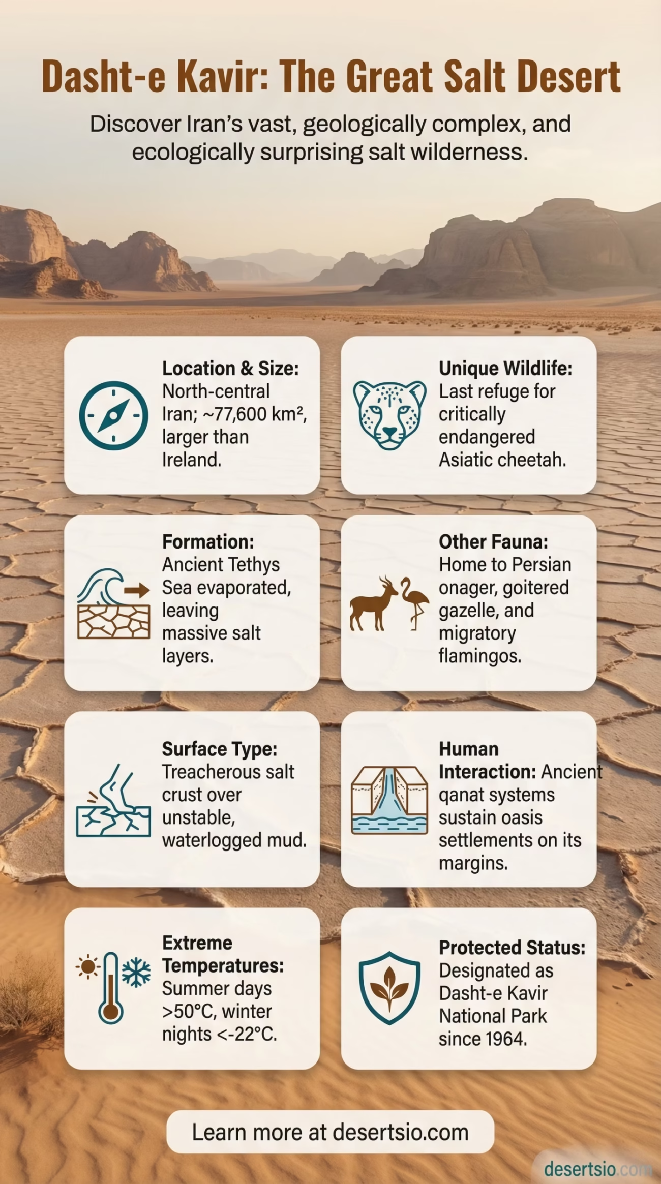
| Total Area | ~77,600 km² (30,000 sq mi) |
| Size Comparison | Larger than the entire country of Panama; roughly the size of Ireland |
| Elevation | 600–900 m (1,970–2,950 ft) above sea level |
| Average Summer Temperature (Day) | Up to 50°C (122°F) |
| Average Winter Temperature (Night) | As low as −22°C (−8°F) |
| Annual Rainfall | Less than 100 mm (3.9 in) |
| Desert Type | Salt flat / Hot desert |
| Dominant Surface | Salt crust (kavir), mud, gravel, sand |
| Nearest Major City | Tehran (~300 km northwest); Isfahan (~200 km southwest) |
| Protected Status | Dasht-e Kavir National Park (established 1964) |
| Key Rivers (Seasonal) | Kavir River, Chaleh Jaz |
Dasht-e Kavir is not your typical desert. Beneath a blinding white crust of salt lies one of the most geologically complex and ecologically surprising landscapes on Earth. Stretching across north-central Iran, this vast saline wilderness — whose name literally translates to “Great Salt Desert” — has formed over millions of years through a process that still shapes the terrain today. Most outsiders assume it is simply barren. It is not.
- Dasht-e Kavir (Great Salt Desert) Desert: Location and Map View
- How Did Dasht-e Kavir Form?
- How Big Is It — Really?
- Temperature: A Desert of Extremes
- Flora and Fauna: Life Against the Odds
- Human Life in the Kavir
- The Salt Crust: A Technical Look
- Neighboring Deserts and Regional Context
- Dasht-e Lut
- Karakum Desert
- Kyzylkum Desert
- Arabian Desert
- Dasht-e Kavir vs. the World’s Great Salt Deserts
- Climate Change and a Desert Under Pressure
- The Kavir in History: Silk Road, Salt, and Survival
- What Makes the Surface So Treacherous?
- Desert Glossary: Key Terms
Dasht-e Kavir (Great Salt Desert) Desert: Location and Map View
How Did Dasht-e Kavir Form?
The story begins in the Tethys Sea — an ancient ocean that once covered much of what is now the Middle East and Central Asia. As tectonic plates shifted and the sea retreated over tens of millions of years, enormous quantities of salt were left behind in sedimentary layers. The Iranian Plateau then began to rise and fold, creating a closed basin with no outlet to the ocean.
Without drainage, water that flows in from surrounding mountains — carrying dissolved minerals — simply evaporates. Over and over, for millennia. The result is a thick, hard kavir (salt crust) that can appear solid but conceals layers of soft, waterlogged mud underneath. Travelers who have stepped through the crust describe it as falling through ice on a frozen lake. Dangerous. Unpredictable.
Seismic activity continues to influence the region. Iran sits at the convergence of the Arabian and Eurasian tectonic plates, and minor earthquakes regularly crack and shift the salt surface — creating the fractured, polygonal patterns that make aerial photographs of Dasht-e Kavir look almost otherworldly.
How Big Is It — Really?
At approximately 77,600 square kilometers, Dasht-e Kavir is larger than Ireland and nearly twice the size of Switzerland. To put it another way — if you placed it over the eastern United States, it would stretch from Philadelphia to Boston and then some. It is the largest desert in Iran and one of the most inhospitable salt deserts on the planet.
And yet its boundaries are often misunderstood. Dasht-e Kavir is frequently confused with Dasht-e Lut — Iran’s other great desert, located to the southeast. These are two distinct geological formations with very different characteristics. Dasht-e Kavir is dominated by salt flats and mud. Dasht-e Lut, by contrast, is famous for its towering sand dunes and yardangs (wind-eroded rock formations), and it holds the record for the hottest land surface temperature ever measured on Earth: 70.7°C (159.3°F), recorded by NASA in 2005.
Temperature: A Desert of Extremes
Dasht-e Kavir operates at the edge of what living organisms can tolerate. Summer days regularly push past 50°C (122°F), with the salt crust radiating heat in every direction. But the same desert drops to −22°C (−8°F) on winter nights. That’s a temperature swing of over 70 degrees Celsius between seasons — and daily swings of 30–40°C within a single 24-hour period are not unusual.
Why such dramatic swings? The desert has virtually no vegetation cover and very low humidity — both of which normally act as thermal buffers. Without them, the surface heats up almost instantly under sunlight and loses heat just as fast after dark. The salt crust itself is a poor heat retainer, making nights in Dasht-e Kavir genuinely freezing even in spring and autumn.
Flora and Fauna: Life Against the Odds
Here is where Dasht-e Kavir surprises most people. Life, stubborn as ever, has found a foothold.
Plant life is sparse but specialized. Halophytes — salt-tolerant plants — colonize the edges of the kavir. Species like Salsola (saltwort), Tamarix (tamarisk), and Halocnemum strobilaceum form low scrub communities along saline margins. Some plants have developed extraordinary salt-excretion mechanisms, essentially sweating out excess salt through their leaves. Deeper into the desert, vegetation nearly disappears entirely.
Animal life, however, is more diverse than the landscape suggests:
- Asiatic cheetah (Acinonyx jubatus venaticus) — critically endangered, with fewer than 50 individuals estimated to remain in Iran. Dasht-e Kavir is one of its last refuges.
- Persian onager (wild ass) — one of the fastest land animals in the Middle East, capable of reaching 70 km/h.
- Goitered gazelle — highly adapted to arid environments, able to extract most of its water needs from vegetation.
- Caracal, sand cat, and wolf — all documented within or near the national park boundaries.
- Reptiles including monitor lizards and various species of agamid lizards dominate the warmer months.
- Migratory flamingos and other waterbirds congregate around seasonal salt lakes — a sight that genuinely shocks first-time visitors to this region.
The national park designation (established in 1964) has provided critical protection for these species, though poaching and habitat pressures remain ongoing concerns.
Human Life in the Kavir
The core of Dasht-e Kavir is essentially uninhabitable. But its margins tell a different story. Settlements have existed along the desert’s edge for thousands of years, sustained by qanats — ancient underground irrigation channels that are, frankly, one of the most impressive engineering achievements of the pre-modern world. Iran is home to over 37,000 active qanats, many of which feed communities bordering Dasht-e Kavir.
Towns like Damghan, Semnan, Shahrood, and Anarak sit on the desert’s periphery. Historically, these were crucial stops on Silk Road trade routes — caravans crossing between Central Asia and Mesopotamia used the desert edges to navigate, relying on these oasis towns for water and provisions.
Traditional nomadic and semi-nomadic groups — including Shahsavan tribes — have long practiced seasonal migration through the region, moving livestock between highland pastures in summer and lower desert margins in winter. This practice, known as transhumance, continues today, though at significantly reduced scale compared to a century ago.
Salt extraction has been a human activity in the kavir for centuries. And still is.
The Salt Crust: A Technical Look
The kavir surface is a layered geological phenomenon. The uppermost crust — which can be anywhere from a few centimeters to over a meter thick — consists primarily of halite (NaCl), gypsum, and other evaporite minerals. Below it lies a layer of waterlogged, near-liquid mud that has no load-bearing capacity.
| Surface Layer | Hard salt crust (halite, gypsum) — 5 cm to 1.5 m thick |
| Sub-surface | Waterlogged saline mud — near-zero structural strength |
| Salinity Levels | Up to 340 g/L in concentrated areas (Dead Sea: ~340 g/L for comparison) |
| Mud Composition | Clay minerals, silt, evaporite residue |
| Crust Formation Rate | Seasonal — grows and dissolves with annual precipitation cycles |
| Surface Patterns | Polygonal cracking (thermal contraction + salt crystal growth) |
The polygonal crack patterns visible across the kavir surface are formed by two competing forces: thermal contraction during cold nights and salt crystal expansion as evaporation concentrates minerals. The result is a tessellated surface that looks almost designed — but is entirely geological.
Neighboring Deserts and Regional Context
Dasht-e Kavir does not exist in isolation. It is part of a broader arid belt stretching across the Iranian Plateau and into Central Asia. Understanding it means looking at its neighbors.
Dasht-e Lut
Iran’s other major desert, located southeast of Dasht-e Kavir. Larger (~51,800 km² for its core zone), hotter, and more visually dramatic — with massive sand dunes and wind-sculpted yardangs. A UNESCO World Heritage Site since 2016. Where Kavir is salt, Lut is sand and rock.
Karakum Desert
Spanning ~350,000 km² across Turkmenistan, the Karakum (“Black Sand”) desert lies to the northeast. It shares the same arid belt but differs dramatically — predominantly sandy with saxaul tree forests and a major irrigation canal (Karakum Canal) running through it.
Kyzylkum Desert
Shared between Uzbekistan and Kazakhstan (~298,000 km²). Another regional neighbor in the Central Asian arid zone. Known for its mineral wealth — gold, uranium — and for the Aral Sea basin, whose dramatic shrinkage over recent decades has accelerated desertification across the broader region.
Arabian Desert
Directly to the southwest, separated by the Zagros Mountains and the Persian Gulf basin. At ~2.3 million km², it dwarfs Dasht-e Kavir — but the two share similar evaporite geology in places, particularly the Rub’ al Khali (Empty Quarter), which also features extensive salt flat zones.
Dasht-e Kavir vs. the World’s Great Salt Deserts
Salt deserts are rarer than sandy ones — and Dasht-e Kavir holds its own on the global stage.
| Desert | Location | Area | Key Feature |
| Salar de Uyuni | Bolivia | ~10,582 km² | World’s largest salt flat; lithium reserves |
| Dasht-e Kavir | Iran | ~77,600 km² | Deep salt crust over unstable mud; critically endangered wildlife |
| Rann of Kutch | India/Pakistan | ~30,000 km² | Seasonal flooding; flamingo breeding ground |
| Chott el-Djerid | Tunisia | ~7,000 km² | North Africa’s largest salt lake; Star Wars filming location |
| Bonneville Salt Flats | USA (Utah) | ~104 km² | Land speed record site; shrinking due to climate change |
Dasht-e Kavir is considerably larger than Salar de Uyuni — the world’s most photographed salt flat — yet receives a fraction of the global attention. That gap is closing, slowly.
Climate Change and a Desert Under Pressure
Iran has experienced a measurable increase in average temperatures over the past four decades — approximately 1.5–2°C above the 20th-century baseline, consistent with broader Middle Eastern climate trends. For Dasht-e Kavir, this translates into longer and more intense heat periods, reduced already-minimal precipitation, and — critically — accelerating desertification at the desert’s margins.
Agricultural land surrounding the desert is under increasing stress. Sandstorm frequency has risen in parts of central Iran over the past two decades, and dust events from the kavir region now affect air quality in cities as far away as Tehran. The Iranian government and various environmental organizations have launched vegetation belt programs — planting drought-resistant shrubs along desert edges to slow sand and dust migration — though these efforts face significant scale and funding challenges.
And the Asiatic cheetah situation is urgent. Fewer than 50 individuals remain. Possibly fewer. Conservation programs involving camera trapping and corridor protection are active in Dasht-e Kavir National Park, but the species’ survival is genuinely uncertain. It is one of the most endangered large mammals on Earth — and this desert is its last stronghold.
The Kavir in History: Silk Road, Salt, and Survival
For ancient traders, Dasht-e Kavir was both a barrier and a navigational tool. Silk Road caravans skirted its edges deliberately, using the desert’s impassability as a natural boundary marker. Cities like Semnan and Damghan — positioned at the northern edge of the kavir — became prosperous precisely because they were the last reliable water sources before the great salt wastes began.
Marco Polo reportedly traveled routes skirting this region in the 13th century, describing “great plains of salt” that could not be crossed without extreme preparation. Whether he passed exactly through what we now call Dasht-e Kavir is debated — but the geographic description fits. Salt extraction from the kavir has been documented in Persian sources dating back at least 2,000 years.
Today, the qanat systems that sustained communities here for millennia are recognized by UNESCO as a significant example of traditional water management — Iran’s ancient qanats received World Heritage status in 2016. Many of the systems serving kavir-edge villages are still operational and still essential.
What Makes the Surface So Treacherous?
This deserves more than a passing mention — because it is genuinely dangerous terrain.
The salt crust’s thickness varies wildly and unpredictably. In some areas it is solid enough to support a vehicle. In others, a single step breaks through into meters-deep saline mud. There is no reliable visual indicator from the surface. Local knowledge — very specific, hard-won local knowledge — is the only reliable guide. Experienced kavir travelers speak of “dead zones” where the crust is always thin, and of seasonal changes that make a passable route in winter completely impassable in spring.
This is not hyperbole. Historical records and local accounts document numerous cases of animals and people becoming trapped in the subsurface mud — unable to extract themselves once the crust breaks. The Persian word kavir itself carries connotations of danger and entrapment in traditional usage.
Desert Glossary: Key Terms
- Kavir — Persian term for a salt flat or salt desert; implies dangerous, unstable ground
- Halophyte — a plant physiologically adapted to survive in high-salinity environments
- Qanat — traditional Iranian underground irrigation channel, gravity-fed from mountain water tables
- Evaporite — a sedimentary rock or mineral formed by the evaporation of water, leaving behind dissolved salts
- Transhumance — seasonal movement of livestock between different elevations or regions, following pasture availability
- Yardang — an aerodynamically shaped ridge carved by wind erosion in desert terrain
