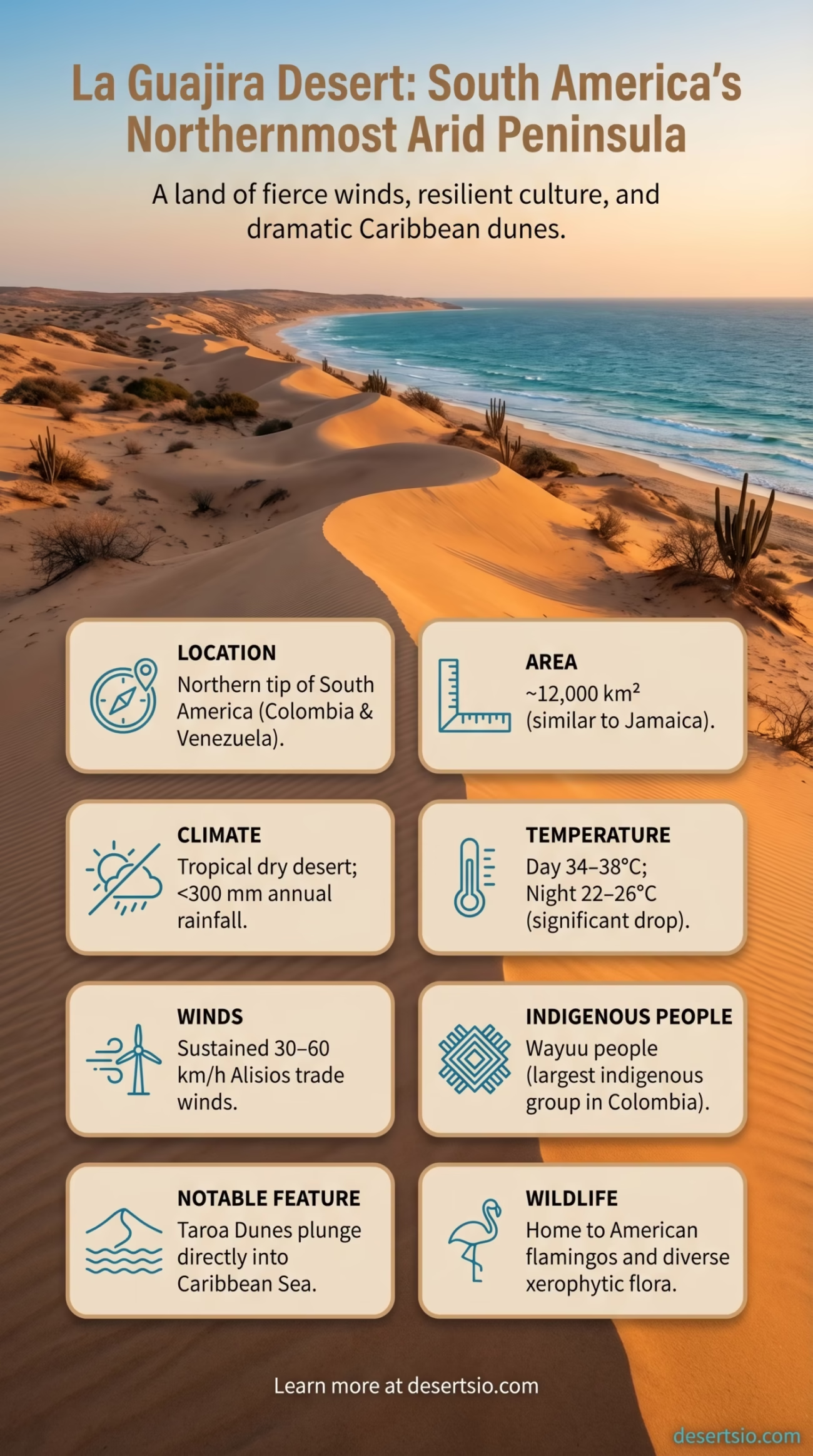
| Location | Northern tip of South America — La Guajira Peninsula, Colombia and Venezuela |
| Total Area | Approximately 12,000 km² (4,600 sq mi) |
| Desert Type | Tropical dry desert / Semi-arid shrubland |
| Annual Rainfall | Less than 300 mm (12 in) per year in the driest zones; some coastal areas receive under 150 mm |
| Average Daytime Temperature | 34–38°C (93–100°F) |
| Average Nighttime Temperature | 22–26°C (72–79°F) — a 10–15°C drop from daytime highs |
| Elevation | 0–900 m (0–2,950 ft); mostly low-lying coastal plain |
| Dominant Winds | Alisios (northeast trade winds) — sustained 30–60 km/h, among the strongest in South America |
| Main Vegetation | Thorn scrub, cacti (particularly cardón), dry bromeliads |
| Indigenous Population | Wayuu people — approx. 270,000 to 380,000 (largest indigenous group in Colombia) |
| Coastline | Borders both the Caribbean Sea and the Gulf of Venezuela |
| Notable Feature | Punta Gallinas — northernmost point of mainland South America |
| Countries | Colombia (~80%) and Venezuela (~20%) |
At the very tip of South America — where the continent meets the Caribbean — there is a place that most maps barely label but that carries an extraordinary story. La Guajira Desert stretches across a sun-scorched peninsula shared by Colombia and Venezuela, defined by fierce trade winds, a near-total absence of rain, and one of the most resilient indigenous cultures on Earth. It is not a desert of towering sand dunes alone; it is a landscape of thorny scrub, terracotta soils, flamingo lagoons, and relentless wind. A place that refuses to be simple.
- La Guajira Desert: Location and Map View
- How Big Is La Guajira — and What Does That Actually Mean?
- Formation: Why Is There a Desert Here?
- Temperature: Heat, Wind, and a Surprising Cooldown
- Flora and Fauna: What Actually Survives Here
- Human Life: The Wayuu and the Desert They Call Home
- The Landscape in Detail: Dunes, Salt Flats, and the Caribbean Edge
- Nearby Deserts and Comparable Arid Regions
- Tatacoa Desert — Colombia
- Médanos de Coro — Venezuela
- Climate Change and La Guajira’s Future
- A Few Technical Details Worth Knowing
- What La Guajira Actually Is
La Guajira Desert: Location and Map View
How Big Is La Guajira — and What Does That Actually Mean?
La Guajira Desert covers roughly 12,000 km², which makes it comparable in size to the entire country of Jamaica — or about twice the size of the US state of Delaware. That framing matters, because the peninsula itself is larger (around 25,000 km²), and the desert gradually transitions into drier and wetter zones depending on how far north you travel. The northernmost zone, known as Alta Guajira, is the true desert core: sparse, wind-blasted, and nearly barren. Moving south, the landscape softens slightly into Media and Baja Guajira, where thorn forests and small seasonal streams appear.
What makes the size feel deceptive is the vertical drama of the environment. It is not vast in the way the Sahara is vast. But within its borders, the contrast between turquoise Caribbean coastline and bone-dry interior is almost shocking. The desert sits at nearly sea level, and the coast is never far away — yet the land holds almost no moisture at all.
Formation: Why Is There a Desert Here?
La Guajira’s aridity is not accidental. It results from a precise convergence of atmospheric and geographic forces that, together, block rainfall with remarkable efficiency.
- The northeast trade winds (locally called alisios) blow nearly year-round at 30–60 km/h, evaporating surface moisture before it can accumulate.
- The peninsula sits in a rain shadow effect created by the Sierra Nevada de Santa Marta to the southwest — one of the world’s highest coastal mountain ranges — which intercepts moisture-laden air from the Pacific and the interior.
- The cold Caribbean upwelling currents along the northern coast reduce evaporation from the sea surface, meaning less moisture enters the air above the peninsula.
- The Intertropical Convergence Zone (ITCZ) — the atmospheric band that brings most tropical rainfall — shifts north and south seasonally but consistently bypasses the deepest parts of La Guajira.
These factors have shaped the peninsula over thousands of years, producing a landscape geologically and climatically distinct from the lush tropics just a few hundred kilometers to the south. The soils are largely entisols and aridisols — young, poorly developed, low in organic matter — exactly what you would expect from a surface that rarely sees rain.
Temperature: Heat, Wind, and a Surprising Cooldown
Daytime temperatures regularly reach 34–38°C (93–100°F), and during the dry season (December through April) these peaks can push higher in inland areas. Yet the nights tell a different story. Temperatures drop to 22–26°C (72–79°F) after sunset — a swing of roughly 10–15°C driven almost entirely by the persistent trade winds, which accelerate heat loss from the surface once the sun disappears.
The wind factor here is impossible to overstate. Sustained winds at 30–60 km/h are not occasional gusts — they are the baseline condition. This makes La Guajira one of the most wind-energetically significant zones in all of Latin America. In fact, the peninsula hosts one of the largest wind farm projects on the continent (the Jepírachi Wind Farm), and further large-scale renewable energy developments have been proposed and partially developed in recent years, a point that has drawn both attention and complex local dialogue.
Flora and Fauna: What Actually Survives Here
Surprisingly — and this catches many people off guard — La Guajira supports a resilient web of life. The vegetation is dominated by xerophytic (drought-adapted) species, and the ecosystem is technically classified as a tropical dry forest in its less arid zones and transitioning to xeric shrubland toward the north.
Key plant species include:
- Cardón cactus (Stenocereus griseus) — the dominant large cactus, reaching up to 8 meters; a critical food and water source for both wildlife and Wayuu communities
- Trupillo (Prosopis juliflora) — a thorny legume tree that fixes nitrogen and provides shade and fodder
- Prickly pear (Opuntia spp.) — widespread across the lower areas
- Dry bromeliads and sparse grasses that appear briefly after the rare rains
Animal life is equally adapted. The Guajira is home to American flamingos (Phoenicopterus ruber), which gather in large flocks at the Laguna de Navío Quebrado — a protected lagoon near Camarones that hosts one of the most important flamingo colonies in northern South America. White-tailed deer, collared peccaries, armadillos, and several raptor species (including the crested caracara) are documented residents. The coastal waters support sea turtles — including the critically endangered leatherback — that nest on the peninsula’s beaches.
Human Life: The Wayuu and the Desert They Call Home
The Wayuu are not visitors to this desert. They are its oldest institution. With a population estimated between 270,000 and 380,000, they constitute the largest indigenous group in Colombia and have inhabited the Guajira Peninsula for at least 3,000 years. Their language, Wayuunaiki, belongs to the Arawakan family — one of the most widespread pre-Columbian language groups of the Americas.
Wayuu society is organized into matrilineal clans (called eiruku), and land, livestock, and inheritance flow through the mother’s line. They have historically been semi-nomadic pastoralists, herding goats and cattle across vast territories in search of water and pasture. Their rancherías (small dispersed settlements) are adapted to the seasonal rhythms of the desert — mobile enough to follow resources, structured enough to maintain deep cultural continuity.
Water scarcity defines daily life. Freshwater access in Alta Guajira relies largely on jagüeyes — shallow hand-dug reservoirs that collect rainfall — and an aging network of government-supplied water trucks (carrotanques). The situation has been repeatedly highlighted in humanitarian and development reports over the past decade, with chronic drought periods intensifying due to broader climate variability. La Niña and El Niño cycles hit La Guajira with outsized force.
The Wayuu are also renowned for their textile work — particularly the mochila bag and chinchorro hammock, both woven with intricate geometric patterns that carry specific clan meanings. UNESCO recognized their weaving traditions in 2017, adding the Wayuu kanas system to the Representative List of Intangible Cultural Heritage.
The Landscape in Detail: Dunes, Salt Flats, and the Caribbean Edge
La Guajira is more texturally complex than most people expect. The Taroa Dunes near Punta Gallinas — the northernmost point of mainland South America — are among the most visually dramatic features: active sand dunes that plunge directly into the Caribbean Sea, a geological oddity found in very few places on Earth. The dunes here can reach 40–50 meters in height and are constantly reshaped by the alisios.
Further inland and along certain coastal stretches, salt flats (salinas) appear where seasonal water bodies evaporate completely. The Salinas de Manaure, near the town of Manaure, are one of Colombia’s largest salt production sites — Wayuu communities have worked these flats for generations, and the facility still produces an estimated 180,000 tonnes of salt annually.
The coastline itself oscillates between turquoise bays with pink-tinged sand (the distinctive color comes from powdered coral and rose quartz mixed into the substrate) and jagged limestone cliffs. Playa del Pilón de Azúcar is frequently cited as one of the most striking coastal landscapes in all of Colombia — not for its resort infrastructure, which barely exists, but for its raw geographic contrast.
Nearby Deserts and Comparable Arid Regions
La Guajira does not exist in isolation on the continent’s arid map. Several other dry regions sit within or near its broader geographic context.
Tatacoa Desert — Colombia
Located in the Huila Department of central Colombia, the Tatacoa Desert covers around 330 km² — far smaller than La Guajira. It shares the semi-arid character but differs dramatically in geology: Tatacoa is a rain shadow desert carved into reddish badlands and grey clay gullies, sitting in a valley hemmed by the Andes. Where La Guajira is windswept and coastal, Tatacoa is enclosed and paleontologically rich (significant vertebrate fossil beds have been documented there).
Médanos de Coro — Venezuela
Just across the Venezuelan border, the Médanos de Coro National Park shares La Guajira’s wind-driven dune dynamics and Caribbean exposure. It covers roughly 91,000 hectares and is a UNESCO World Heritage Site. The two desert systems are climatically connected — both are shaped by the same northeast trade winds — though Médanos de Coro is more strictly a sand dune system while La Guajira encompasses a broader arid ecosystem.
Further afield, La Guajira shares ecological parallels with the Sechura Desert of coastal Peru — another tropical coastal desert shaped by cold ocean upwelling and trade wind dynamics. Both are narrow coastal arid zones where marine biodiversity thrives just meters from near-barren land. The mechanisms are strikingly similar even though the continents differ.
Climate Change and La Guajira’s Future
The peninsula is already one of Colombia’s most climate-vulnerable regions, and the data being gathered in recent years reinforces that concern. Rainfall variability has increased — droughts are longer, and when rain does arrive, it can come in concentrated, erosive bursts. Groundwater tables are declining in several documented areas. Goat herds, which number in the hundreds of thousands across the peninsula, are adding sustained pressure to degraded soils already struggling to support vegetation.
At the same time, La Guajira’s wind resource is extraordinary — average wind speeds of 9–11 m/s at 80-meter hub height make it one of the most competitive onshore wind zones in the Western Hemisphere. The tension between large-scale energy development and Wayuu territorial rights has become one of Colombia’s most closely watched environmental-justice conversations, with national and international legal processes actively ongoing as of 2024.
And the flamingos — they are still there. For now. The Laguna de Navío Quebrado’s water levels fluctuate with rainfall, and years of drought reduce its suitability as flamingo habitat. Ornithologists monitoring the colony have recorded population dips correlating directly with extended dry periods. It is a small but visible indicator of what the broader ecosystem faces.
A Few Technical Details Worth Knowing
| Wind Speed (avg. at 80m hub height) | 9–11 m/s — top-tier for onshore wind energy |
| Evapotranspiration Rate | Potential evapotranspiration exceeds precipitation by a factor of 10–15x in Alta Guajira |
| Soil Classification | Predominantly Aridisols and Entisols; low organic matter, high erodibility |
| Dune Height (Taroa) | Up to 40–50 m — active aeolian dunes descending to sea level |
| Salt Production (Manaure) | ~180,000 tonnes/year |
| Flamingo Colony (Navío Quebrado) | One of the largest in northern South America; population fluctuates with rainfall cycles |
| Wayuu Population | 270,000–380,000; majority in Colombia, significant presence in Venezuela |
| Jepírachi Wind Farm Capacity | 19.5 MW (installed); first commercial wind farm in Colombia, operational since 2004 |
What La Guajira Actually Is
La Guajira is not easy to categorize. It is technically a tropical dry desert, but it borders the Caribbean. It is geographically remote, but it contains one of the continent’s densest indigenous cultures. It is ecologically fragile, but it sits on top of some of the world’s best wind energy potential. And it ends — quite literally — at the northernmost point of South America, where dunes slide into the sea.
Deserts often get described in terms of absence: no rain, no trees, no people. La Guajira pushes back against that framing at every turn. It is a desert defined as much by what is present — the Wayuu, the flamingos, the salt flats, the relentless alisios — as by what is missing. That is, in the end, what makes it worth understanding.
