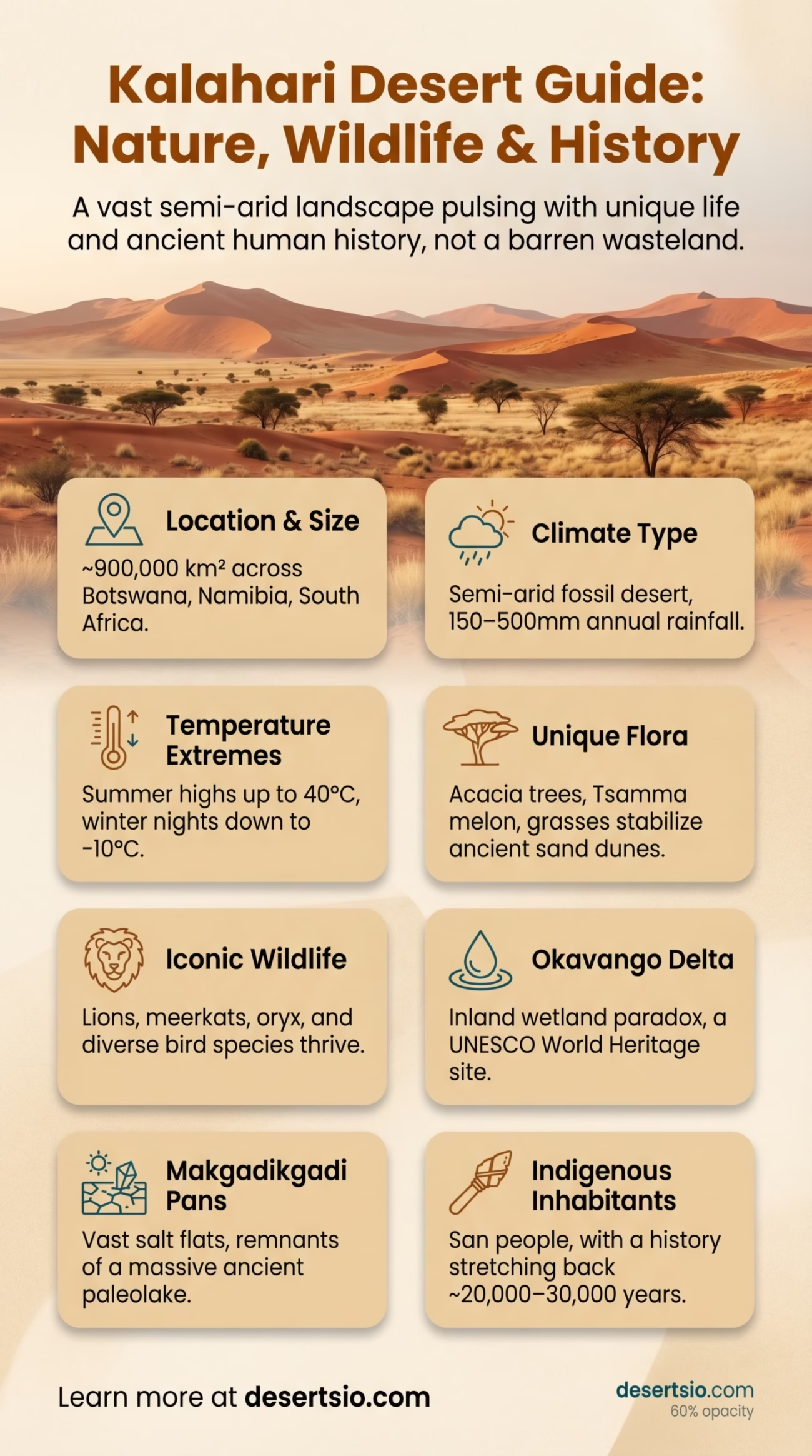
| Location | Southern Africa — Botswana, Namibia, South Africa |
| Total Area | ~900,000 km² (347,000 sq mi) |
| Type | Semi-arid savanna desert (fossil desert) |
| Dominant Countries | Botswana (largest share), Namibia, South Africa |
| Average Annual Rainfall | 150–500 mm (varies by region) |
| Daytime Temperature | Up to 40°C (104°F) in summer |
| Nighttime Temperature | Down to −10°C (14°F) in winter nights |
| Highest Point | ~1,200 m above sea level (central plateau) |
| Major Rivers | Okavango, Molopo, Nossob (seasonal) |
| Soil Type | Red-orange Kalahari sand (aeolian) |
| Dominant Vegetation | Grasses, acacia trees, shrubs |
| Notable Wildlife | Lions, meerkats, oryx, springbok, brown hyena |
| Indigenous Inhabitants | San (Bushmen) people |
| UNESCO Recognition | Okavango Delta — World Heritage Site (2014) |
The Kalahari is not a desert in the way most people picture one. No endless barren dunes, no lifeless silence. Instead, it pulses — with grass, with animals, with ancient human stories stretching back tens of thousands of years. Covering roughly 900,000 km² across Botswana, Namibia, and South Africa, the Kalahari is technically classified as a semi-arid fossil desert, which means it once was a true hyperarid desert but now receives enough rainfall to sustain a surprising diversity of life. That distinction matters more than it might seem.
Kalahari Desert: Location and Map View
How Big Is the Kalahari, Really?
To put it in perspective: the Kalahari is larger than the state of Texas — and Texas is not a small place. It covers nearly the entire country of Botswana and spills generously into Namibia and South Africa’s Northern Cape province. If you stacked it against Western Europe, it would comfortably swallow France and Germany combined.
Most of the terrain sits on a vast inland plateau at elevations between 850 and 1,200 meters. The famous red-orange sands — carried and shaped by ancient winds — stretch in parallel dune ridges called streets, though most of these dunes are now stabilized by vegetation rather than actively shifting.
Formation: A Desert Frozen in Time
The Kalahari’s origins go back roughly 60 million years, to a period when the African continent’s interior began drying out following tectonic shifts and the gradual retreat of ancient sea systems. Wind-blown sediments accumulated over millions of years, building the thick layer of Kalahari sand — in some areas reaching depths of over 300 meters — that defines the region today.
During the Pleistocene epoch (roughly 2.6 million to 11,700 years ago), the Kalahari was significantly more arid — a true desert. Massive paleolake systems, including what geologists call Paleolake Makgadikgadi, once covered large portions of the basin. That lake, at its peak, was larger than present-day Lake Victoria. It dried up. What’s left are the Makgadikgadi Pans — vast salt flats that are eerie, flat, and oddly beautiful.
The sand itself is ancient. And it carries that history in its color.
Temperature: Extremes You Wouldn’t Expect
The Kalahari plays temperature games that catch visitors off guard. Daytime summer temperatures regularly hit 38–40°C (100–104°F), baking the sand until the air above it shimmers. But step into a winter night — especially in June or July — and temperatures can plunge to −10°C (14°F) in the colder, elevated areas.
That’s a swing of 50°C between extremes. Within a single day in winter, you can realistically go from freezing at dawn to sweating by midday. The dry air is the culprit — without moisture, the land loses heat rapidly after sunset and absorbs it just as fast at sunrise.
Seasonal Temperature Overview
| Season | Daytime High | Nighttime Low |
| Summer (Nov–Feb) | 35–40°C (95–104°F) | 18–22°C (64–72°F) |
| Autumn (Mar–May) | 28–33°C (82–91°F) | 8–14°C (46–57°F) |
| Winter (Jun–Aug) | 20–26°C (68–79°F) | −10 to 0°C (14–32°F) |
| Spring (Sep–Oct) | 30–38°C (86–100°F) | 10–18°C (50–64°F) |
Flora: More Green Than You’d Think
Because the Kalahari receives between 150 and 500 mm of rainfall annually (depending on the region), it supports a vegetation cover that no true hyperarid desert could. Rainfall increases from southwest to northeast — the southwest is drier and harsher, while the northeast transitions into lush bushveld.
Key plant species include:
- Camelthorn acacia (Vachellia erioloba) — the iconic tree of the Kalahari, with massive spreading canopies and seed pods that elephants and livestock both prize
- Shepherd’s tree (Boscia albitrunca) — known locally as witgat, used medicinally by indigenous communities for centuries
- Tsamma melon (Citrullus lanatus) — a wild relative of the watermelon, critically important as a water source for both wildlife and the San people
- Driedoring and other shrub species that stabilize the ancient dune ridges
- Kalahari red grass — seasonal but explosive after rains, turning the desert floor gold-red
The Okavango Delta, fed by waters flowing in from Angola, creates a remarkable inland wetland within the broader Kalahari basin — a paradox of water in the desert that sustains ecosystems found nowhere else on Earth.
Fauna: Surprisingly Alive
The Kalahari supports one of Africa’s most intact predator-prey ecosystems. The Kgalagadi Transfrontier Park — spanning 38,000 km² across Botswana and South Africa — protects a remarkable range of species in conditions that are demanding even by African standards.
Predators
- Kalahari lion — known for darker, fuller manes than East African lions; adapted to dry conditions
- Cheetah
- Leopard
- Brown hyena (near-endemic to southern Africa)
- African wild dog
Prey & Other Wildlife
- Springbok — the dominant antelope, famous for its “pronking” leaps
- Gemsbok (oryx) — thrives in extreme heat
- Eland
- Meerkat — a Kalahari icon, standing sentinel on termite mounds
- Ground squirrel, porcupine, aardvark
- Over 200 bird species, including the sociable weaver with its enormous colonial nests
The gemsbok deserves special mention. It can tolerate internal body temperatures of up to 45°C (113°F) — a physiological feat achieved through a nasal heat exchange system that cools blood flowing to the brain. Evolution at its most precise.
Human Life: The San and Beyond
The San people — sometimes called Bushmen, though “San” is the preferred term — have inhabited the Kalahari for an estimated 20,000 to 30,000 years. Genetic studies consistently identify the San as one of the oldest continuous human populations on Earth. Their knowledge of the desert is extraordinary: which plants hold water underground, how to track animals across hard, dry sand, how to navigate by stars across featureless terrain.
Traditional San groups, particularly the !Kung (the ! represents a click consonant in their language) and the G//ana and G/wi communities of the central Kalahari, developed one of the most sophisticated hunter-gatherer cultures ever documented. Their click-based languages — with phonemes that most non-native speakers cannot easily reproduce — remain linguistically unique on the planet.
Today, the San population across southern Africa numbers approximately 90,000 to 100,000 people. Many continue to live in or near the Kalahari, though modern pressures — sedentarization, land disputes, economic marginalization — have reshaped traditional ways of life significantly.
And then there are the Tswana and other Bantu-speaking communities who settled across Botswana and South Africa’s Kalahari fringes over the past several centuries, bringing cattle herding and agriculture to the region’s edges. The town of Ghanzi in Botswana — population around 15,000 — sits in the heart of Kalahari cattle country.
The Kalahari and Climate Change: A Shifting Sand Story
Recent research published in peer-reviewed journals raises a pressing question: is the Kalahari becoming more desert-like? A 2019 study modeled future dune mobility under various climate scenarios and found that by 2100, previously stabilized Kalahari dunes could become actively mobile again — meaning the fossil desert may wake up.
That’s not a small concern. Dune reactivation would threaten agricultural land, water sources, and communities across Botswana and Namibia. Rainfall patterns in the region are already becoming less predictable, with droughts deepening in frequency and intensity. The 2019–2020 drought in Botswana was described as one of the most severe in decades, severely affecting both livestock and wildlife.
The Okavango Delta — that improbable inland sea — is also under pressure. Its water flow depends on rainfall far to the north in Angola, and deforestation in those upstream catchments is reducing the delta’s intake year by year. The delta supports around 200,000 large mammals and provides water and livelihood for hundreds of thousands of people.
Kalahari vs. Namib: Two Very Different Neighbours
The Namib Desert lies to the west, separated from the Kalahari by the escarpment of the Great Escarpment and the transition zone of the Karoo. These two deserts are often confused — and they couldn’t be more different.
| Feature | Kalahari Desert | Namib Desert |
| Type | Semi-arid / fossil desert | True hyperarid coastal desert |
| Annual Rainfall | 150–500 mm | Under 25 mm (some areas near zero) |
| Age | ~60 million years (sand) | ~55–80 million years (one of Earth’s oldest) |
| Dune Height | Mostly low, stabilized | Up to 300+ m (Sossusvlei dunes) |
| Vegetation | Grasses, acacias, shrubs | Minimal; specialized succulents |
| Wildlife Density | High | Low, highly specialized |
To the north, the Etosha Pan — part of Namibia’s Etosha National Park — shares certain ecological characteristics with the Kalahari’s salt pan systems, particularly the Makgadikgadi. Both are remnants of ancient lake systems. Both attract massive concentrations of flamingos, zebra, and wildebeest during wet seasons.
The Makgadikgadi: A Desert Within a Desert
Within the Kalahari lies one of the planet’s most surreal landscapes — the Makgadikgadi Pans, covering roughly 12,000 km². During the dry season, these salt flats are blinding white, silent, and almost completely devoid of life. In the wet season? They flood shallow, attracting one of Africa’s largest zebra migrations — up to 30,000 zebras move through the area between November and April.
Flamingos — both lesser and greater species — breed on the temporary lakes in numbers that can reach tens of thousands. It’s a spectacle that rivals anything in East Africa’s Rift Valley, yet far fewer people know it exists.
Kalahari Desert — Key Facts Overview
- Area: ~900,000 km² — larger than Texas, bigger than France and Germany combined
- Sand depth: Up to 300 meters in some areas
- Indigenous people: San (Bushmen), with presence dating back 20,000–30,000 years
- Rainfall range: 150 mm (dry southwest) to 500 mm (wet northeast)
- Kgalagadi Transfrontier Park: 38,000 km², a cross-border conservation area
- Okavango Delta: UNESCO World Heritage Site since 2014; supports ~200,000 large mammals
- Makgadikgadi Pans: 12,000 km²; remnant of a lake once larger than Lake Victoria
Conservation and the Future of the Kalahari
The Kgalagadi Transfrontier Park, established formally in 2000, was one of Africa’s first peace parks — a cross-border protected area jointly managed by Botswana and South Africa. It covers 38,000 km² and allows wildlife to move freely across what were once hard political boundaries. This model has since influenced transfrontier conservation efforts across the continent.
Beyond formal parks, community-based natural resource management (CBNRM) programs in Botswana have placed wildlife management — and the income it generates — directly in the hands of local communities. Some of these programs generate millions of dollars annually from photographic tourism and controlled hunting concessions, giving communities a direct financial stake in keeping ecosystems intact.
The results are measurable. Botswana today holds one of Africa’s largest elephant populations — estimated at 130,000 to 150,000 animals — a figure that reflects both conservation success and, increasingly, the complex challenge of human-wildlife coexistence in a landscape where both need space and water.
The Kalahari is many things at once: ancient and fragile, teeming and harsh, deeply human and strikingly wild. It doesn’t fit neatly into a single category — and that’s precisely what makes it one of Africa’s most compelling landscapes.