
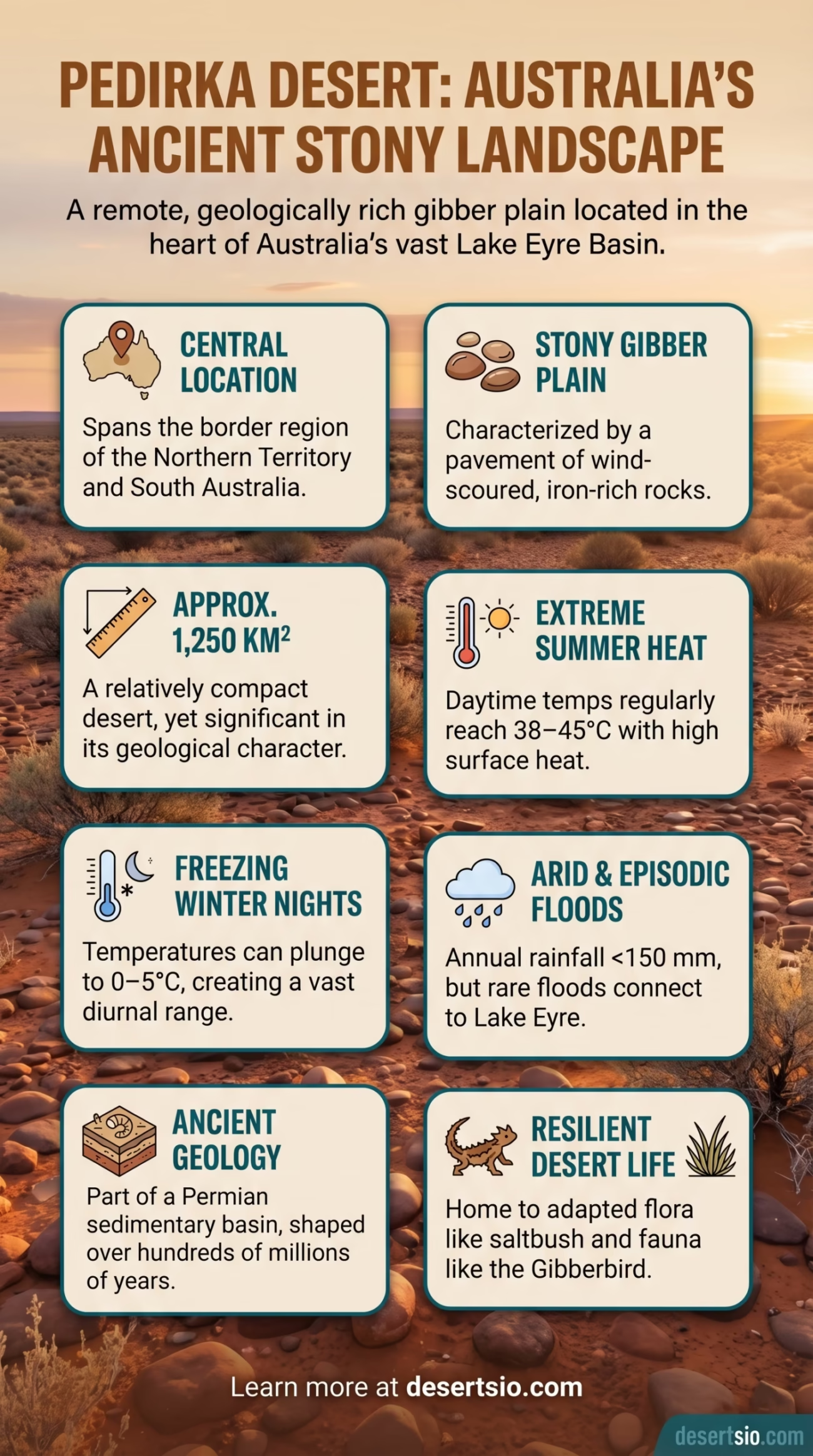
| Location | Central Australia, Northern Territory & South Australia |
| Area | Approximately 1,250 km² (core desert zone) |
| Type | Stony desert (gibber plain) |
| Elevation | ~100–200 m above sea level |
| Annual Rainfall | Less than 150 mm per year |
| Average Daytime Temperature | 38–45°C in summer; 18–25°C in winter |
| Average Nighttime Temperature | 5–15°C in summer; below 5°C (near freezing) in winter |
| Nearest Major Town | Alice Springs (~170 km northwest) |
| Surrounding Deserts | Simpson Desert, Tirari Desert, Sturt Stony Desert |
| Drainage Basin | Lake Eyre (Kati Thanda) Basin |
| Primary Vegetation | Sparse chenopod shrubland, desert grasses |
| Indigenous Custodians | Arabana and Arrernte peoples |
The Pedirka Desert sits quietly in one of Australia’s most remote corners — a vast, sun-scorched expanse of gibber plains and ancient geology that most people will never encounter, yet deserves far more attention than it receives. Located in the Northern Territory and South Australia border region, it forms part of the sprawling Lake Eyre Basin, a drainage system so enormous it covers roughly one-sixth of the entire Australian continent.
It is one of Australia’s smaller named deserts, but “small” here is relative. At approximately 1,250 km², it is still larger than many European principalities and American counties combined. And what it lacks in size, it makes up for in raw, geological character.
Pedirka Desert: Location and Map View
How Big Is the Pedirka Desert?
The Pedirka Desert covers roughly 1,250 square kilometers — a number that sounds modest until you place it beside something familiar. That is larger than the city of Los Angeles and about twice the size of Singapore. Within the broader context of Australian arid zones, though, it is a relatively compact desert, dwarfed by neighbors like the Simpson Desert (approximately 176,500 km²) and the Great Victoria Desert (424,400 km²).
Yet the Pedirka is not really defined by its area alone. It functions as a transitional zone — a meeting point between the stony gibber plains of the south and the red sand dune country of central Australia. That ecological overlap gives it an unusual character, almost like two deserts folded into one.
Formation: How Did the Pedirka Desert Come to Be?
The geology here tells a long story. The landscape of the Pedirka region was shaped over hundreds of millions of years, beginning with ancient inland seas that once covered much of central Australia during the Mesozoic and early Cenozoic eras. As those seas retreated, sedimentary layers were deposited — layers that later weathered into the characteristic gibber stones (smooth, iron-rich rocks) that define the desert surface today.
The Pedirka Basin itself is a recognized geological feature — a Permian-aged sedimentary basin named after the same region. It contains coal measures and other sedimentary sequences deposited during the Permian period, roughly 290 to 252 million years ago. This basin is distinct from the desert itself but they share the same name and the same remote, ancient ground.
Tectonic uplift, prolonged erosion, and Australia’s gradual drift northward into warmer latitudes all contributed to the aridification of this region over the past 15 million years or so. What was once lush and wet became increasingly dry — a process that has been studied extensively through pollen records and sediment cores drawn from ancient lake beds in the area.
Temperature and Climate: A World of Extremes
The Pedirka Desert operates on a brutal thermal clock. Days and nights are not just different — they feel like separate climates entirely.
- Summer daytime: Temperatures routinely reach 38–45°C, with ground surface temperatures on the gibber plains exceeding 70°C in direct sunlight.
- Summer nights: Drops to 5–15°C — a swing of up to 35°C within a single 24-hour period.
- Winter days: Pleasant and mild, typically 18–25°C, often described as some of the finest weather in inland Australia.
- Winter nights: Temperatures plunge close to or below freezing (0–5°C), sometimes producing ground frost.
- Annual rainfall: Fewer than 150 mm per year on average, and highly irregular — some years receive almost nothing, followed by rare flood events.
That diurnal temperature range — the gap between day and night — is one of the defining features of stony deserts globally. The gibber rocks absorb heat during the day and radiate it outward at night, creating an almost oven-like effect on the surface. Stony deserts heat up faster and cool down faster than sandy ones.
Flora and Fauna: Life on the Gibber Plain
Life in the Pedirka is sparse but resilient. The gibber plain surface — essentially a pavement of polished, wind-scoured stones — is one of the harshest environments for plant growth anywhere on Earth. Yet vegetation does persist, particularly in drainage channels and lower depressions where moisture briefly collects after rare rainfall events.
Plants found in and around the Pedirka region include:
- Bluebush (Maireana spp.) — a hardy chenopod shrub common across Australian stony deserts
- Saltbush (Atriplex spp.) — drought-tolerant and salt-adapted, especially in low-lying areas
- Spinifex grass (Triodia spp.) — tough, resinous grass clumps that anchor loose soils
- Ephemeral wildflowers — after rainfall, the desert can briefly explode with color, including daisies, poppies, and parakeelya
Fauna is equally adapted to survival under pressure. The region supports several species that are well-documented across the broader Lake Eyre Basin ecosystem:
- Reptiles: Thorny devil (Moloch horridus), bearded dragon, various skinks and geckos
- Birds: Gibberbird (Ashbyia lovensis) — a species essentially endemic to gibber plains, along with budgerigars, letter-winged kites, and Australian pratincoles
- Mammals: Fat-tailed dunnart, kultarr (a tiny carnivorous marsupial), feral camels (an introduced species now numbering over 300,000 across Australian deserts)
- Invertebrates: Shield shrimp and fairy shrimp appear in temporary water pools after flooding — creatures that can lie dormant as eggs for years, then hatch within hours of rain
The Gibberbird deserves a special mention. This small, yellow-and-brown bird is one of the only vertebrates in Australia so closely tied to gibber desert habitat that its very name reflects the landscape it calls home. Spotting one is considered something of a milestone among ornithologists working in the region.
Human Life: Who Calls This Desert Home?
The Pedirka Desert lies within Country (in the Indigenous Australian sense — a deeply spiritual and custodial relationship with land) traditionally belonging to the Arabana and Arrernte peoples. The Arabana people, in particular, are the traditional custodians of much of the Lake Eyre Basin, including areas that overlap with the Pedirka region.
For tens of thousands of years — current archaeological evidence suggests continuous occupation in the broader region for at least 50,000 years — Aboriginal peoples moved through and managed this landscape with sophisticated ecological knowledge. They understood the seasonal movements of animals, the location of water sources (often hidden beneath the surface or concentrated in specific rock formations), and the cycles of drought and flood that define this region.
Today, permanent settlement near the Pedirka is extremely limited. The small community of Finke (Aputula), located to the northeast, is one of the closest inhabited localities. Alice Springs, roughly 170 km to the northwest, serves as the primary regional hub for supplies, healthcare, and services.
The Old Ghan Railway — a historic rail line that once attempted to connect Adelaide to Darwin through this unforgiving interior — passed near the Pedirka region. The line was eventually abandoned due to repeated flood damage. The old track bed is now part of the Ghan Heritage Trail, a reminder that even infrastructure bends to the will of this landscape.
Neighboring Deserts: The Broader Arid Zone
The Pedirka does not exist in isolation. It sits at the center of one of the world’s largest continuous arid zones — the Australian Desert Belt — surrounded by several other named deserts, each with distinct characteristics.
| Desert | Area (km²) | Primary Type | Key Feature |
| Simpson Desert | ~176,500 | Sand dune (erg) | Longest parallel dunes on Earth |
| Tirari Desert | ~15,250 | Sand / salt lake | Borders Kati Thanda–Lake Eyre directly |
| Sturt Stony Desert | ~29,750 | Gibber plain | Classic “gibber desert” of South Australia |
| Strzelecki Desert | ~80,250 | Sand plain | Dune fields and mulga scrub |
| Pedirka Desert | ~1,250 | Stony/gibber | Geological basin; transitional zone |
Of these, the Tirari Desert is perhaps the Pedirka’s closest neighbor in both geography and ecology — both drain into the Lake Eyre Basin and both feature gibber-heavy terrain. The Sturt Stony Desert further south is a useful comparison point: larger and better-documented, it represents the “classic” Australian gibber plain experience and shares many of the same plant and animal species as the Pedirka.
The Pedirka Basin: A Geological Footnote With Real-World Implications
The Pedirka Basin — distinct from the desert surface but part of the same geographic region — has drawn attention from geologists for decades. It is a Permian sedimentary basin containing coal measures, which historically attracted energy exploration interest. Glacially deposited sediments within the basin suggest that central Australia once experienced glacial conditions during the Permian period, when the continent was positioned much closer to the South Pole as part of the supercontinent Gondwana.
That is a striking fact. The same ground that now bakes at 45°C once lay beneath glacial ice. And the rocks underfoot carry that frozen history locked inside their layering.
More recently, the basin has been assessed for its groundwater potential. The Great Artesian Basin — one of the largest and deepest freshwater reservoirs on Earth, underlying roughly 22% of Australia — has edges that extend near the Pedirka region, though the desert itself sits largely outside the main basin extent.
Floods in a Desert: The Lake Eyre Connection
One of the most counterintuitive things about the Pedirka region is that it floods. Not often — but dramatically, and with ecological consequences that ripple across thousands of kilometers.
The Pedirka sits within the catchment of Kati Thanda–Lake Eyre, Australia’s largest salt lake and the lowest point on the continent at approximately 15 meters below sea level. When monsoon rains fall far to the north in Queensland and the Northern Territory, water travels slowly across this vast, flat basin — sometimes taking weeks to arrive at its destination.
When Lake Eyre fills — which happened significantly in 2010–2011 and again in 2019 — the ecological response is extraordinary. Waterbirds arrive in hundreds of thousands from across Australia. Fish that have been dormant in dried-up waterholes suddenly find themselves in a connected, living system. The desert is briefly, improbably, a wetland.
These flood events are becoming an increasingly important subject of climate research. Scientists are tracking how changing rainfall patterns in northern Australia affect the frequency and volume of Lake Eyre fill events — and by extension, the ecology of every desert that drains into it, including the Pedirka.
Comparing the Pedirka: Similar Deserts Elsewhere
Pedirka Desert (Australia)
- Gibber / stony plain surface
- Drains into enclosed basin (Lake Eyre)
- Extreme diurnal temperature range
- Low but episodic rainfall with flooding
- Ancient Indigenous occupation
Sturt Stony Desert (Australia)
- Gibber plain — most comparable surface type
- Also drains toward Lake Eyre Basin
- Similar temperature extremes
- Better documented, more visited
- 23x larger in area
Reg Deserts of North Africa
- Stony desert surface (reg = gibber equivalent)
- Drains into closed basins (chotts/sebkhas)
- Extreme heat, cold nights
- Ancient human occupation history
- Much larger in scale
The closest global analog to the Pedirka in terms of surface character is the reg desert of North Africa — flat, stone-paved plains that form when wind removes fine particles and leaves a lag of coarser material behind. The process is called deflation, and it produces remarkably similar landscapes on opposite sides of the world. And both are vastly underappreciated compared to their sandier, more photogenic neighbors.
A Desert Worth Knowing
The Pedirka Desert rarely appears on lists of the world’s great deserts. No dramatic dunes. No famous monuments rising from the sand. It is, by most definitions, a quiet desert — ancient, geologically rich, ecologically specialized, and deeply embedded in the cultural heritage of the people who have known it longest.
And that is precisely why it matters. The world’s lesser-known deserts often carry the most precise stories about how landscapes form, how life adapts, and how human cultures develop in relationship with extreme environments. The Pedirka is one of those places. Stony, remote, and stubbornly itself.