| Location | Southern Australia (Western Australia & South Australia) |
| Type | Hot desert (sandy & stony) |
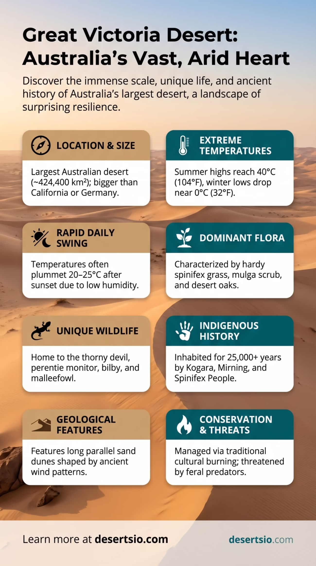
| Area | ~424,400 km² (163,900 sq mi) |
| Comparison | Larger than California (~423,970 km²); about 1.5× the size of the United Kingdom |
| Elevation Range | 150–450 m above sea level |
| Average Annual Rainfall | 125–250 mm (highly irregular) |
| Summer High Temperature | Up to 40°C (104°F) during the day |
| Winter Low Temperature | Can drop to 0°C (32°F) at night |
| Day–Night Temperature Difference | Often 20–25°C within a single 24-hour period |
| Dominant Vegetation | Spinifex grass, bluebush, mulga scrub |
| Key Wildlife | Thorny devil, perentie monitor, malleefowl, bilby, dingo |
| Indigenous Peoples | Kogara, Mirning, Spinifex People (Pila Nguru) |
| Named After | Queen Victoria, by explorer Ernest Giles (1875) |
| Conservation Status | Parts protected under the Great Victoria Desert Bioregion |
| Nearest Major City | Kalgoorlie (~500 km northwest) |
The Great Victoria Desert is Australia’s largest desert — and yet, despite that title, it remains one of the least understood arid landscapes on Earth. Stretching across the southern edge of Western Australia and into South Australia, it covers roughly 424,400 square kilometers. That’s bigger than California. Bigger than Germany. And almost no one outside of Australia can point to it on a map.
It doesn’t have the towering red dunes of the Simpson Desert or the iconic rock formations of the outback’s tourist corridors. What it has instead is something harder to photograph: a raw, almost indifferent vastness. Flat, hot, dry — and surprisingly, alive.
Great Victoria Desert: Location and Map View
How the Great Victoria Desert Formed
The desert’s formation is tied to Australia’s ancient geological story. The continent sits firmly over a stable tectonic plate, with no mountain ranges tall enough to capture moisture from the Indian Ocean to the west or the Southern Ocean to the south. This creates a rain shadow effect that has kept the interior arid for tens of millions of years.
During the Pleistocene epoch (roughly 2.6 million to 11,700 years ago), the region experienced alternating wetter and drier phases. The linear sand dunes that now dominate parts of the landscape were shaped during these drier glacial periods, when low vegetation and strong winds rearranged the surface sediment into long, parallel ridges — some stretching for over 100 kilometers without interruption.
The substrate beneath is ancient — in some places, Precambrian bedrock dating back over 500 million years sits just below the surface. This geological stability means the landscape has remained largely unchanged in structure, even as the climate shifted around it.
Size and Scale — In Perspective
At 424,400 km², the Great Victoria Desert is larger than every U.S. state except Alaska. Compare it to the United Kingdom — you could fit the entire UK inside it roughly 1.7 times. Even within Australia, it is the single largest desert unit, though the broader “Australian Desert” network collectively covers about 1.5 million km².
And it’s not a monoscape. The terrain shifts — from gibber plains (flat surfaces covered in polished stones) to long red sand dune corridors, from dry salt lakes to dense mulga woodland patches. The diversity within the desert itself surprises most people who study it for the first time.
Temperature Extremes: Day and Night
Summer days in the Great Victoria Desert regularly reach 40°C (104°F). In winter, the same landscape can drop to near 0°C (32°F) after sunset. That’s a swing of 20 to 25 degrees Celsius within a single 24-hour cycle — a thermal whiplash that defines desert life everywhere, but feels especially sharp here.
Why such extreme temperature swings? Low humidity is the core reason. In humid environments, water vapor in the atmosphere acts as insulation — trapping heat at night and moderating daytime highs. In desert air, with almost no moisture, heat escapes rapidly after sunset. The ground radiates warmth upward, the sky offers nothing back, and temperatures plummet.
Annual rainfall across the desert averages between 125 and 250 mm, but the timing and location of rain is highly unpredictable. Some zones may receive no measurable rain for two or three consecutive years, then get hit with a brief but intense storm that floods dry creek beds within hours.
Flora: What Actually Grows Here
Spinifex dominates. Specifically, Triodia basedowii — a tough, resinous grass that forms dense, spiky hummocks across the sandy plains. It’s almost impossible to walk through without discomfort, and it burns intensely when dry. Yet it anchors the sand, provides shelter for small reptiles, and rebounds quickly after fire. It’s not pretty. It works.
Beyond spinifex, the desert supports:
- Mulga (Acacia aneura) — a slow-growing acacia that can survive decades of drought; its foliage channels rainwater directly toward its own root zone
- Bluebush (Maireana spp.) — low shrubs that tolerate high soil salinity near dry lake margins
- Desert oak (Allocasuarina decaisneana) — taller trees that grow along ancient watercourses and provide shade rare in the open desert
- Grevillea and hakea species — flowering shrubs that produce nectar and attract birds, particularly honeyeaters
After rain — if and when it comes — the desert transforms. Ephemeral wildflowers like native daisies, mulla mullas, and desert peas erupt across the plains in dense color. It’s a short-lived spectacle that locals and researchers track closely, and one that highlights just how much biological potential lies dormant in the soil.
Fauna: The Animals Built for This
The wildlife here is specialized in ways that take a moment to appreciate. The thorny devil (Moloch horridus) — one of Australia’s most iconic reptiles — collects moisture through hygroscopic grooves in its skin, channeling dew and rain directly to its mouth. No standing water needed.
The perentie (Varanus giganteus), Australia’s largest monitor lizard at up to 2.5 meters long, moves across the desert with surprising efficiency, ambushing prey from behind spinifex clumps. And the bilby (Macrotis lagotis) — the desert’s own answer to the rabbit — burrows deep to avoid daytime heat and forages nocturnally.
Notable fauna of the Great Victoria Desert:
- Malleefowl — builds enormous incubation mounds from organic matter, using decomposition heat to warm eggs
- Princess parrot (Polytelis alexandrae) — a rare, nomadic species that follows flowering and seeding events across the desert
- Marsupial mole (Notoryctes typhlops) — blind, near-impossible to observe, and still poorly studied; it “swims” through loose sand
- Dingo — the apex predator across much of the Australian interior, present in the Great Victoria as a top-order regulator of the food web
Human Life in the Great Victoria Desert
People have lived here for at least 25,000 years — possibly longer. The Kogara, Mirning, and Pila Nguru (Spinifex People) are among the Indigenous groups whose country spans this desert. Their knowledge of the land — water sources, seasonal food availability, fire management — represents one of the most sophisticated long-term ecological systems ever developed by any human culture.
The Pila Nguru, in particular, returned to parts of their traditional country after years of displacement, and today manage significant portions of the desert under the Spinifex Land Trust, established in 1997 after a successful native title claim — one of the largest in Australian history at the time.
Permanent non-Indigenous settlements are essentially absent within the desert core. The nearest town of any size, Kalgoorlie, sits roughly 500 km to the northwest and functions as a supply hub for the region’s mining operations rather than a gateway to the desert itself.
Traditional ecological knowledge (TEK) held by the Pila Nguru includes detailed understanding of over 150 plant species used for food, medicine, and tool-making — knowledge accumulated and tested across hundreds of generations in one of Earth’s harshest environments.
Nearby Deserts: The Australian Arid Zone
The Great Victoria Desert doesn’t exist in isolation — it’s part of a vast arid network covering about 70% of the Australian continent. Understanding the regional context adds real depth to how this particular desert fits into the bigger picture.
| Desert | Area (km²) | Key Feature |
| Great Victoria Desert | 424,400 | Australia’s largest single desert; spinifex-dominated |
| Gibson Desert | 156,000 | North of Great Victoria; rocky plains and red sand |
| Great Sandy Desert | 267,250 | Northwest Australia; parallel dune systems, extremely hot |
| Simpson Desert | 176,500 | Famous for red dunes; includes the longest parallel dunes on Earth |
| Nullarbor Plain | ~200,000 | Treeless limestone plateau; southern edge of Great Victoria |
The Gibson Desert directly to the north shares much of the same flora and fauna as the Great Victoria, with a slightly rockier substrate. The Nullarbor Plain forms the desert’s southern boundary — technically not a sand desert but an ancient seabed exposed as a flat, treeless limestone platform, now famous for the world’s longest straight road and railway sections.
Comparing the Great Victoria to Similar Deserts Worldwide
In global terms, the Great Victoria Desert most closely resembles the Kalahari Desert in southern Africa — both are semi-arid to arid, both support surprisingly rich biodiversity beneath a dry exterior, and both are home to Indigenous peoples with deep, ancient connections to the land (the San people of the Kalahari being a direct parallel to the Pila Nguru). The Kalahari, at roughly 930,000 km², is significantly larger, but the ecological dynamics are strikingly similar.
The Patagonian Desert in South America also draws some comparison — both are cold-influenced, both feature low scrub vegetation, and both are largely bypassed by mainstream tourism despite their scale. The Patagonian Desert covers about 673,000 km², making it South America’s largest desert.
What sets the Great Victoria apart, though, is its biological endemism. A significant percentage of its reptile species exist nowhere else on Earth. That level of evolutionary isolation — the result of Australia’s long separation from other landmasses — makes it scientifically distinct from almost any comparable desert system.
Conservation and Current Pressures
The desert is not without threats. Invasive species — particularly feral cats and European rabbits — have had measurable impacts on small mammal populations across the Australian interior. Feral cats alone are estimated to kill over 1.5 billion native animals annually across Australia, with arid zone species being especially vulnerable due to their low reproductive rates.
Climate projections for the region suggest increasing aridity through the 21st century, with more frequent and intense drought periods. The CSIRO (Australia’s national science agency) projects that the Great Victoria Desert region may experience temperature increases of 1.5 to 3°C by 2070 under moderate emissions scenarios — a shift that would push an already extreme environment further toward the margins of what existing species can tolerate.
And yet, the Indigenous-led land management programs operating across the desert offer a genuine counter-narrative. Controlled burning — cultural burning — practiced by groups like the Pila Nguru creates a mosaic of fire-age habitats that increases overall biodiversity. Research published in the last decade has confirmed what Traditional Owners have known for millennia: fire, used correctly, is not a threat to this landscape — it’s a tool.
Ernest Giles and the Desert’s European “Discovery”
The desert takes its name from Queen Victoria, bestowed by explorer Ernest Giles during his 1875 crossing of the region. Giles traversed the desert on camels — imported to Australia precisely because they could handle the conditions — and described the journey as among the most grueling of his career. His accounts of heat, thirst, and featureless horizons helped cement the early European perception of the Australian interior as simply “empty.” It wasn’t, of course. It was already home to people, animals, and a functioning ecological system thousands of years in the making.
That framing — empty, hostile, useless — shaped Australian policy toward the interior for decades. Only relatively recently has the scientific and cultural value of the Great Victoria Desert begun to receive the recognition it deserves.
A Desert Worth Understanding
The Great Victoria Desert holds more complexity per square kilometer than most landscapes that get far more attention. Its reptile diversity alone would justify serious scientific focus. Its Indigenous history adds a human dimension that reshapes how the word “desert” should be understood — not as absence, but as a different kind of presence.
And as climate patterns shift globally, arid ecosystems like the Great Victoria are moving from the periphery of ecological concern to its center. What survives here, what adapts, and what disappears will tell researchers a great deal about the future of life under heat stress — information that matters well beyond Australia’s borders.