| Location | Kazakhstan, Central Asia |
| Area | Approximately 38,000 km² (14,670 sq mi) |
| Type | Sandy desert (barchan dunes dominant) |
| Climate Zone | Continental arid |
| Average Summer Temperature | Up to 40–45°C (104–113°F) during the day |
| Average Winter Temperature | −15°C to −25°C (5°F to −13°F) |
| Day/Night Temperature Difference | Up to 20–25°C (36–45°F) variation within a single day |
| Annual Precipitation | 100–150 mm (3.9–5.9 in) |
| Dominant Vegetation | Saxaul trees, wormwood (Artemisia), feather grass |
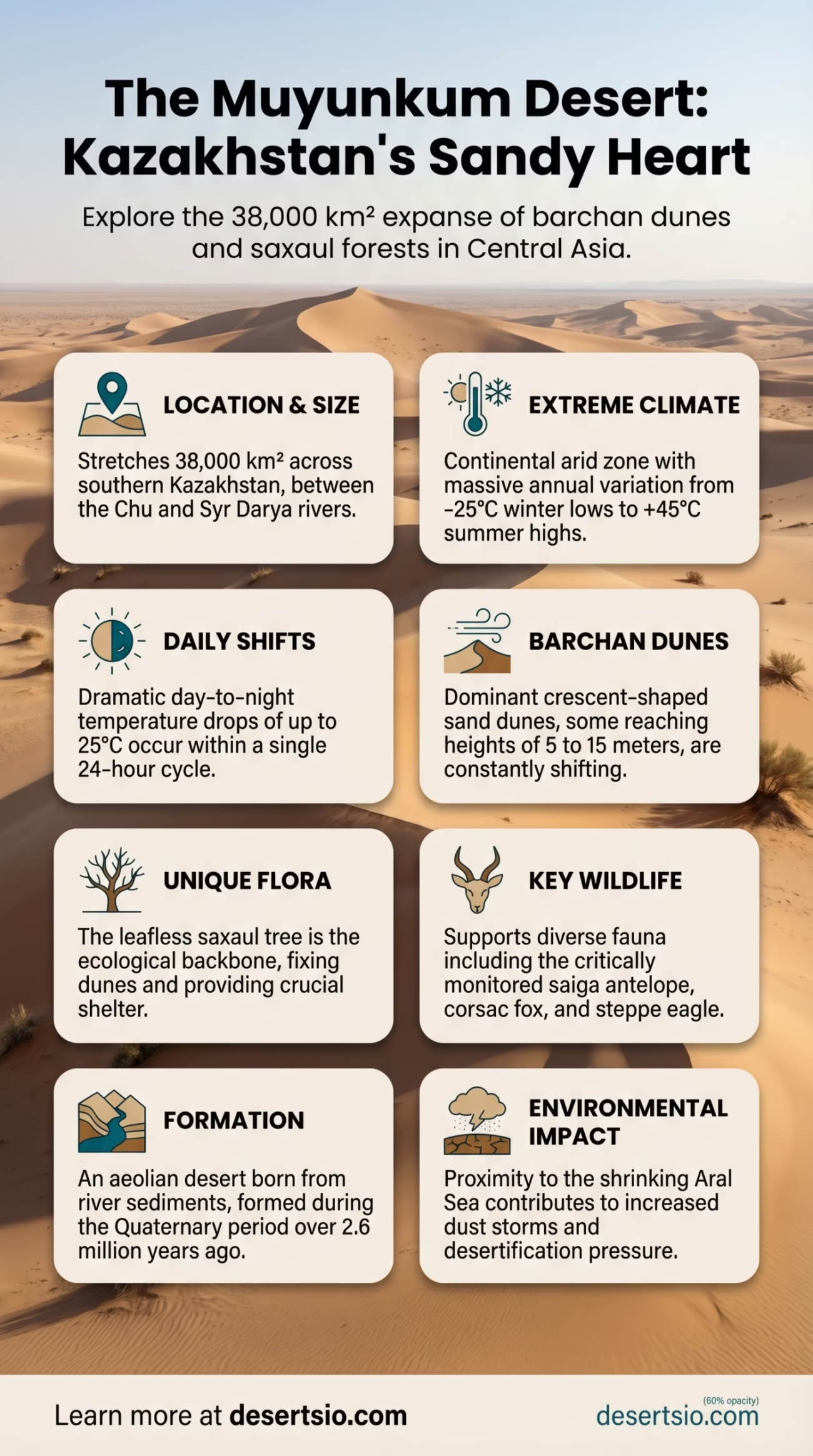
| Key Wildlife | Saiga antelope, corsac fox, steppe eagle, sand lizards |
| Major River Nearby | Syr Darya (to the south) |
| Administrative Region | Kyzylorda and Zhambyl regions, Kazakhstan |
| Formation Age | Quaternary period (approx. 2.6 million years ago to present) |
The Muyunkum Desert sits in the heart of southern Kazakhstan — and most people have never heard of it. That’s somewhat surprising, given that it stretches across roughly 38,000 square kilometers, making it one of the larger sandy deserts in Central Asia. It occupies the basin between the Chu River to the north and the Syr Darya River to the south, locked inside a geography that rarely makes headlines but tells one of the more fascinating geological stories on the continent.
Moyynkum Desert: Location and Map View
How Big Is the Muyunkum Desert?
At 38,000 km², the Muyunkum is roughly the size of Switzerland — or, to put it differently, nearly twice the area of Wales. It’s not the largest desert in Central Asia (that title belongs to the Karakum and the Kyzylkum), but it’s substantial enough that driving across it without preparation is genuinely dangerous. The desert forms a crescent-shaped lowland, bordered by the Chu-Ili Mountains to the northeast and the flat steppe grasslands to the west.
The terrain itself is dominated by barchan dunes — crescent-shaped sand formations that shift position with the prevailing winds. Some of these dunes reach heights of 5 to 15 meters. Between the dune fields, flat sandy plains called takyr spread out, often cracked and hardened like sun-dried clay after brief rainfall events.
Formation: How Did This Desert Come to Be?
The Muyunkum’s origin traces back to the Quaternary period, beginning roughly 2.6 million years ago. During this time, the uplift of mountain ranges across Central Asia — particularly the Tian Shan — began blocking moisture-carrying air masses from reaching the interior lowlands. The rain shadow effect intensified, and what were once semi-arid steppes gradually dried into true desert.
The Chu River played a direct role. Over thousands of years, the river deposited immense quantities of sand and sediment into this basin. Wind then sculpted those sediments into the dune systems visible today. It’s essentially an aeolian desert built on fluvial foundations — wind-shaped, but river-born.
And it’s still moving. Active dune migration in the Muyunkum is documented at rates of 5 to 15 meters per year in some zones, driven by the dominant northeast winds.
Temperature: Day, Night, and the Extreme In Between
The Muyunkum operates on extremes. Summer days regularly push 40–45°C (104–113°F), with ground-surface temperatures sometimes exceeding 60°C (140°F) — hot enough to blister exposed skin on contact. Then night comes, and temperatures can drop 20–25°C within hours. In winter, the same landscape flips entirely: temperatures plunge to −15°C to −25°C (5°F to −13°F), and occasional snowfall covers the dunes.
This is a continental arid climate in its most uncompromising form. The absence of large water bodies nearby means there’s no thermal buffer. What you get instead is the full amplitude of a landlocked interior — scorching summers, brutal winters, and almost no transition in between.
Flora and Fauna: Life That Refuses to Quit
Vegetation in the Muyunkum is sparse but surprisingly resilient. The saxaul tree (Haloxylon persicum and Haloxylon aphyllum) is the ecological backbone of the desert — a leafless, gnarled tree that fixes dunes in place with its deep root systems and provides critical shelter for dozens of animal species. Wormwood (Artemisia species) carpets large areas, especially on sandier substrates. Feather grass colonizes the stabilized margins.
Fauna is where the Muyunkum becomes genuinely remarkable:
- Saiga antelope (Saiga tatarica) — one of the world’s most ancient ungulates, migrating through Muyunkum seasonally. The species is critically monitored after a catastrophic mass die-off of over 200,000 individuals in 2015 across Kazakhstan’s steppe and desert zones.
- Corsac fox (Vulpes corsac) — a pale, compact predator perfectly adapted to open sandy terrain.
- Steppe eagle (Aquila nipalensis) — classified as Endangered on the IUCN Red List, with Central Asian desert corridors forming a key part of its range.
- Sand lizards and agamas — several species occupy rocky and dune microhabitats.
- Great gerbil (Rhombomys opimus) — a colonial burrowing rodent that engineers its own ecosystem within the sand.
The saxaul forests of the Muyunkum — technically a desert, technically a forest — are protected in parts of Kazakhstan under conservation agreements. They’re irreplaceable. Removing them accelerates desertification at a measurable rate.
Human Life in the Muyunkum
Permanent settlement inside the Muyunkum is minimal, but the desert has never been entirely uninhabited. Kazakh nomadic communities historically moved livestock through the desert’s edges during seasonal migrations — a practice called zhailau (summer pasture movement) in Kazakh tradition. The desert itself was a boundary zone, not a destination.
Today, the Kyzylorda and Zhambyl administrative regions border the desert. Small rural settlements exist on the desert’s fringes, largely dependent on livestock herding — sheep, camels, and horses — and limited agriculture where the Chu River provides irrigation. The town of Chu (Shu) to the northeast serves as the closest urban center of significance.
Nomadic practices haven’t disappeared entirely. Some Kazakh herding families still practice transhumant grazing, moving animals between the steppe and desert margins based on seasonal pasture availability. It’s a centuries-old rhythm that the landscape itself seems to demand.
The Muyunkum and the Broader Aral Sea Crisis
Any serious discussion of the Muyunkum Desert cannot ignore its proximity to one of the 20th century’s most significant environmental disasters: the shrinkage of the Aral Sea. The Syr Darya — which borders the Muyunkum to the south — was one of the two rivers that once fed the Aral Sea. Decades of aggressive irrigation diversion reduced the Syr Darya’s flow dramatically, and the Aral Sea lost over 90% of its volume between the 1960s and 2010s.
The consequence for the Muyunkum region? Increased desertification pressure on its southern margins, shifting wind patterns, and the addition of salt-laden dust storms originating from the exposed Aral seabed — a new dust source that didn’t exist 60 years ago. Scientists now track this as an expanding environmental feedback loop across Kazakhstan and Uzbekistan.
And the situation is still evolving. The North Aral Sea partial restoration project (the Kok-Aral Dam, completed in 2005) has shown measurable success — water levels rose by several meters in the northern basin — but the southern sections remain dry. For the Muyunkum’s southern edge, the dust problem persists.
Nearby Deserts: Central Asia’s Desert Corridor
The Muyunkum doesn’t exist in isolation. Central Asia hosts a chain of deserts that form one of the world’s most extensive arid corridors, stretching from the Caspian Sea to the Chinese border.
| Desert | Country | Area | Type |
| Kyzylkum | Kazakhstan / Uzbekistan | ~298,000 km² | Sandy |
| Karakum | Turkmenistan | ~350,000 km² | Sandy / stony |
| Betpak-Dala | Kazakhstan | ~75,000 km² | Stony / clay desert |
| Muyunkum | Kazakhstan | ~38,000 km² | Sandy (barchan dunes) |
| Ustyurt Plateau | Kazakhstan / Uzbekistan | ~200,000 km² | Plateau / clay |
The Kyzylkum Desert — whose name means “red sand” in Turkic — is the Muyunkum’s most immediate large neighbor to the southwest. Both are sandy deserts shaped by similar Quaternary processes, but the Kyzylkum is nearly eight times larger and hosts significant gold mining operations (including the Muruntau mine, one of the world’s largest open-pit gold mines). The Muyunkum, by contrast, remains relatively undeveloped and ecologically intact in its core zones.
The Betpak-Dala steppe-desert to the north — sometimes called the “Hungry Steppe” — shares a climatic profile with the Muyunkum but differs in surface composition: it’s predominantly stony and clay-based rather than sandy. Saiga antelope migrate between both zones, making them ecologically linked despite their geological differences.
Muyunkum vs. Karakum: A Brief Comparison
The Karakum Desert in Turkmenistan is the Muyunkum’s most structurally similar counterpart in the region — both are sandy, both are shaped by aeolian processes, and both share a continental arid climate. But scale and geology separate them sharply.
Muyunkum Desert
- Area: ~38,000 km²
- Kazakhstan
- Barchan dune systems
- Saxaul forests intact
- Lower development pressure
- Saiga antelope habitat
Karakum Desert
- Area: ~350,000 km²
- Turkmenistan
- Mixed dune and flat terrain
- Home to the Darvaza Gas Crater
- Major natural gas reserves
- More arid (80–150 mm rainfall)
Conservation Status and Current Pressures
The Muyunkum faces several documented environmental pressures:
- Overgrazing — livestock numbers on the desert’s margins have increased since the 1990s, degrading the saxaul and wormwood vegetation that stabilizes dunes.
- Sand encroachment — with vegetation cover thinning, active dune migration threatens agricultural land and infrastructure on the desert’s edges.
- Water diversion from the Chu River — irrigation extraction upstream reduces water availability in the desert basin, lowering groundwater tables that support deep-rooted desert vegetation.
- Climate change — projections for Central Asia indicate a temperature increase of 2–4°C by 2100 under current trajectories, which will extend arid conditions further into currently semi-arid margins.
Kazakhstan has made commitments under international frameworks to restore degraded land, including saxaul planting programs. Between 2021 and 2023, Kazakhstan’s government announced reforestation targets specifically referencing saxaul restoration in its southern deserts — a direct response to both desertification and carbon sequestration goals.
Saxaul isn’t just ecologically useful. It’s carbon-dense for a desert tree, with research suggesting mature saxaul forests sequester carbon at rates comparable to some dryland shrublands in North Africa. That makes the Muyunkum’s saxaul zones economically relevant in ways that weren’t on anyone’s radar two decades ago.
What Makes Muyunkum Distinctive
Most desert enthusiasts focus on the Sahara, the Arabian Desert, or the Gobi. Central Asian deserts, including the Muyunkum, remain genuinely under-documented in global literature. That’s partly a language barrier (most primary research exists in Russian and Kazakh), and partly because the region lacks the dramatic topography of dune seas like the Erg Chebbi or the Rub’ al Khali.
Muyunkum is a functioning desert ecosystem — not yet collapsed, still supporting migratory wildlife, and still maintaining its saxaul forest cover in core areas. At 38,000 km², it has ecological significance. Its location at the intersection of climate change vulnerability, Aral Sea fallout, and Central Asian steppe ecology makes it relevant to current environmental discussions.
The name “Muyunkum” itself comes from Kazakh: муйынқұм, roughly translating to “neck sand” — a reference to the elongated, narrow shape of the desert’s sandy zone as it stretches between the Chu and Syr Darya rivers. Simple geography encoded in a name. And once you know what it means, the desert makes more visual sense on a map.