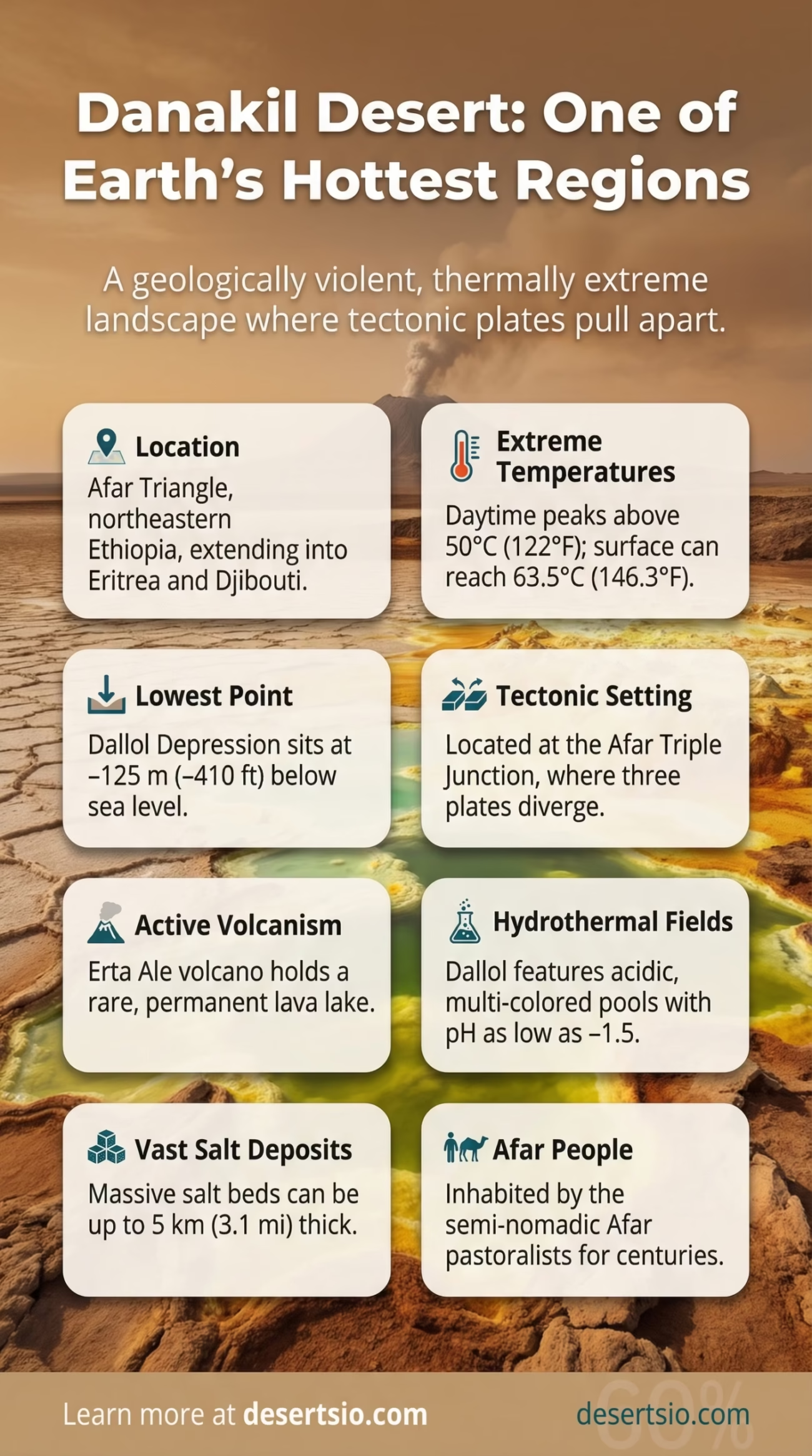
| Location | Afar Triangle, northeastern Ethiopia; extends into Eritrea and Djibouti |
| Area | ~137,000 km² (52,900 sq mi) |
| Elevation | As low as −125 m (−410 ft) below sea level (Dallol Depression) |
| Type | Volcanic / Salt Desert |
| Average Daytime Temperature | ~41°C (106°F); peaks above 50°C (122°F) in summer |
| Average Nighttime Temperature | ~25–30°C (77–86°F) |
| Annual Rainfall | Less than 25 mm (1 inch) per year |
| Hottest Recorded Temperature | 63.5°C (146.3°F) surface temperature — among the highest reliably recorded on Earth |
| Major Features | Dallol hydrothermal field, Erta Ale volcano, Karum Salt Lake, Afar Triangle rift |
| Tectonic Setting | Afar Triple Junction — where three tectonic plates diverge |
| Salt Crust Thickness | Up to 5 km (3.1 mi) deep in some areas |
| Permanent Inhabitants | Afar people (Danakil people) |
| Nearest Major City | Mekelle, Ethiopia (~150 km southwest) |
DANAKIL Desert: Location and Map View
The Danakil Desert sits at the meeting point of three tectonic plates — and it shows. This is not just an arid landscape. It is one of the most geologically violent, thermally extreme, and visually otherworldly places on the surface of the planet. Located in the Afar Triangle of northeastern Ethiopia, with portions stretching into Eritrea and Djibouti, the Danakil spans approximately 137,000 km² — roughly the size of Greece. Temperatures here regularly exceed 50°C (122°F). Acid pools glow in neon yellows and greens. A stratovolcano holds a permanent lava lake. And people still live here.
How Did the Danakil Form?
The Danakil Depression is a direct product of plate tectonics at its most dramatic. The region sits at the Afar Triple Junction, where the African Plate, the Arabian Plate, and the Somali Plate are slowly pulling apart from each other. This rifting process — active and ongoing — has caused the ground to sink well below sea level. The Dallol Depression reaches −125 meters (−410 feet), making it the lowest point in Africa and one of the lowest on Earth.
Millions of years ago, the sea repeatedly flooded this depression and then evaporated — leaving behind massive salt deposits, some up to 5 kilometers thick. The volcanic activity heating these salt beds from below creates the hydrothermal systems that produce Dallol’s iconic acid pools and sulfur chimneys. The whole system is still actively forming. New crust is being created here in real time, offering geologists a rare window into how ocean basins are born.
Temperature and Climate: The Numbers Are Brutal
The Danakil holds the record for the highest average annual temperature of any inhabited place on Earth — around 34°C (93°F) year-round. Daytime highs routinely climb above 41°C (106°F), with surface temperatures recorded at 63.5°C (146.3°F) during peak summer months. That is hot enough to cook food.
Nighttime brings only partial relief. Temperatures drop to roughly 25–30°C (77–86°F) after dark — a swing of about 15–20°C between day and night. Humidity is low, winds are occasional and hot, and rainfall almost never comes. Annual precipitation sits below 25 mm (about 1 inch). For comparison, the Sahara Desert averages 25–100 mm per year depending on location — making parts of the Danakil even drier.
Danakil Climate Overview
- Highest average annual temperature of any inhabited location: ~34°C (93°F)
- Summer daytime peak: above 50°C (122°F)
- Nighttime low: ~25–30°C (77–86°F)
- Annual rainfall: under 25 mm
- Humidity: extremely low — evaporation rate far exceeds precipitation
- Dominant wind: dry, hot winds from the rift valley
How Big Is the Danakil — And What Does That Mean?
At roughly 137,000 km², the Danakil Desert is larger than the entire country of Greece (131,957 km²) and about the same size as the U.S. state of Iowa. It is not the largest desert by any measure — the Sahara, for instance, dwarfs it at 9.2 million km² — but size is not the Danakil’s defining characteristic. Intensity is. Few places on Earth pack this level of geological, thermal, and chemical extremity into a single landscape.
The depression itself — the lowest and hottest portion — covers a smaller area within the broader desert, but it’s the zone that draws the most scientific attention. Dallol, located near the center of this depression, sits at −48 meters (−157 feet) below sea level and hosts one of the most complex hydrothermal surface systems ever studied.
Erta Ale: The Living Volcano
Erta Ale is arguably the most compelling feature of the entire Danakil. A shield volcano rising to 613 meters (2,011 feet) above the desert floor, it contains one of the world’s few permanent lava lakes — a feature so rare that only a handful of volcanoes on Earth currently possess one. The name “Erta Ale” in the Afar language (the language of the region’s indigenous people) translates to “smoking mountain” — and it has been smoking for well over a century.
The lava lake at Erta Ale is not static. It churns, surges, and occasionally overflows. In 2017, significant lava flows forced a temporary evacuation of nearby settlements. Volcanologists monitor it continuously — not just for safety, but because it provides direct access to magma chemistry that is otherwise only obtainable through deep drilling. The lava here reflects a basaltic composition consistent with mid-ocean ridge volcanism, reinforcing the theory that the Danakil is essentially an emerging oceanic spreading center on land.
Dallol: A Hydrothermal Landscape Like No Other
Dallol is something else entirely. The hydrothermal field here produces acid pools with pH values as low as −1.5 — meaning the liquid is more acidic than battery acid in some spots. Temperatures within the pools frequently exceed 100°C (212°F) at the surface. Bright yellow sulfur deposits, green iron-rich brines, white salt chimneys — the color palette is almost aggressively unnatural.
Scientists have studied whether any microbial life exists in these conditions. A 2019 study published in Nature Ecology and Evolution found no evidence of active microbial life in the most extreme Dallol pools, despite finding similar life in analogous environments elsewhere. This makes Dallol one of the very few places on Earth that appears genuinely uninhabitable — even for extremophiles. The findings have direct implications for the search for life on other planets, particularly Mars and Jupiter’s moon Europa.
The Afar People: Human Life in the Danakil
The Afar people — also called the Danakil people — have inhabited this desert for thousands of years. Their total population across Ethiopia, Eritrea, and Djibouti is estimated at around 1.5 to 2 million, though only a portion live within the most extreme desert zones. They are traditionally semi-nomadic pastoralists, moving seasonally with their camels, goats, and cattle to follow whatever water and vegetation exist.
Salt mining has defined Afar economic life for centuries. The Karum Salt Lake (also known as Lake Asale) produces large salt slabs — called “amole” — that were historically used as currency throughout the Horn of Africa. Salt caravans from the Danakil traveled as far as the Ethiopian highlands and beyond. This trade route, though now supplemented by modern transport, still functions today. Camel caravans still make the crossing. The amole still move.
Afar society is organized around clan structures, with traditional leadership systems that govern water rights, grazing land, and conflict resolution. Life here demands extraordinary resilience — heat, water scarcity, and the logistical challenges of living near active volcanic terrain are daily realities.
Flora and Fauna: What Actually Survives Here
Biodiversity in the Danakil is sparse, but not absent. Vegetation is limited to scattered drought-resistant shrubs, acacia trees near water sources, and salt-tolerant grasses along the fringes of salt flats. The harshest zones — the hydrothermal areas, the deepest salt plains — are essentially barren.
Animal life follows the same pattern: adapted, resilient, limited. Species found in and around the Danakil include:
- Dromedary camels — domesticated and essential to Afar transport and economy
- Hamadryas baboons — found in rocky escarpment zones at higher elevations
- Somali wild ass (Equus africanus somaliensis) — critically endangered; one of the rarest wild equids on Earth
- Nubian ibex — inhabits the cliff edges of the rift escarpment
- Various raptor species — including eagles and vultures that patrol the thermal updrafts
- Salt-adapted invertebrates — found in the hypersaline lake margins
The Somali wild ass deserves particular mention. Fewer than 1,000 individuals are estimated to remain in the wild globally, and the Danakil region represents one of its last refuges. Habitat pressure and competition with domestic livestock are the primary threats.
Neighboring Deserts and Regional Context
The Danakil does not exist in isolation — geographically or ecologically. It sits within the broader arid belt of the Horn of Africa, surrounded by related desert and semi-arid environments:
| Desert / Region | Location | Key Similarity to Danakil |
| Ogaden Desert | Eastern Ethiopia / Somalia | Same arid Horn of Africa belt; shared Afar-Somali arid corridor |
| Chalbi Desert | Northern Kenya | Similar volcanic origin, salt lake features (Lake Turkana nearby) |
| Sahara Desert | North Africa | Extreme heat and aridity; much larger but less geologically active |
| Atacama Desert | Chile / Peru | Comparable hyper-aridity; also studied for astrobiology due to lifeless zones |
The comparison with the Atacama Desert is particularly interesting. Both are hyper-arid environments with zones scientifically considered near-lifeless. Both are used as Mars analog research sites. And both sit in tectonically or volcanically active regions — though the Danakil’s surface-level volcanic activity is far more immediate and visible.
Scientific Significance and Current Research
The Danakil is not just extreme — it is scientifically invaluable. Several research fronts are actively using this landscape as a study site:
- Astrobiology: NASA and ESA-affiliated researchers study Dallol’s chemistry as a proxy for hostile planetary environments, particularly early Mars conditions
- Plate tectonics: The Afar Triple Junction is one of the only places on Earth where continental rifting to oceanic spreading can be observed in process — above sea level
- Volcanology: Erta Ale’s permanent lava lake provides continuous real-time data on basaltic magma behavior
- Extremophile biology: Even the negative results at Dallol (no microbial life) refine scientific understanding of the absolute limits of habitability
- Climate modeling: Long-term temperature records from the Danakil contribute to global extreme heat modeling — increasingly relevant as climate change pushes heat records worldwide
In 2020 and 2021, researchers confirmed new volcanic fissure activity near Erta Ale, with GPS and satellite data from the Copernicus Earth Observation program tracking ground deformation of several centimeters — evidence that the rift is still widening. Slowly, but measurably.
Early Human History: The Danakil’s Deeper Story
There is one more dimension to this desert that rarely gets the attention it deserves. The Afar region — the broader geological zone of which the Danakil is a part — is among the most important sites in paleoanthropology. The fossilized remains of Australopithecus afarensis, including the famous specimen known as “Lucy” (discovered in 1974 near Hadar, in the Afar Depression), were found here. The region has yielded hominin fossils dating back more than 3.5 million years.
The same geological forces that make the Danakil so extreme today — rift activity, sediment deposition, lake formation and drying — are also responsible for preserving these ancient bones. The depression’s geology acts as a kind of natural archive. And it keeps giving: new fossil sites in the Afar Triangle continue to be identified and excavated.
The Danakil in Numbers
- −125 m: lowest point in the Danakil Depression (Dallol area)
- 63.5°C: highest reliably recorded surface temperature
- −1.5 pH: acidity level in some Dallol hydrothermal pools
- 5 km: depth of salt deposits in parts of the basin
- 3.5 million years: age of hominin fossils found in the Afar region
- 613 m: elevation of Erta Ale volcano above the desert floor
- ~1,000: estimated remaining wild Somali wild ass individuals globally
The Danakil Desert is, in the most literal sense, a place where the Earth is coming apart. Tectonic forces are actively reshaping the landscape — widening the rift, deepening the depression, feeding the volcanoes. In geological terms, millions of years from now, the Red Sea may flood this basin and create a new arm of ocean. What is now desert will be seafloor. That process has already begun. The Danakil just hasn’t finished yet.