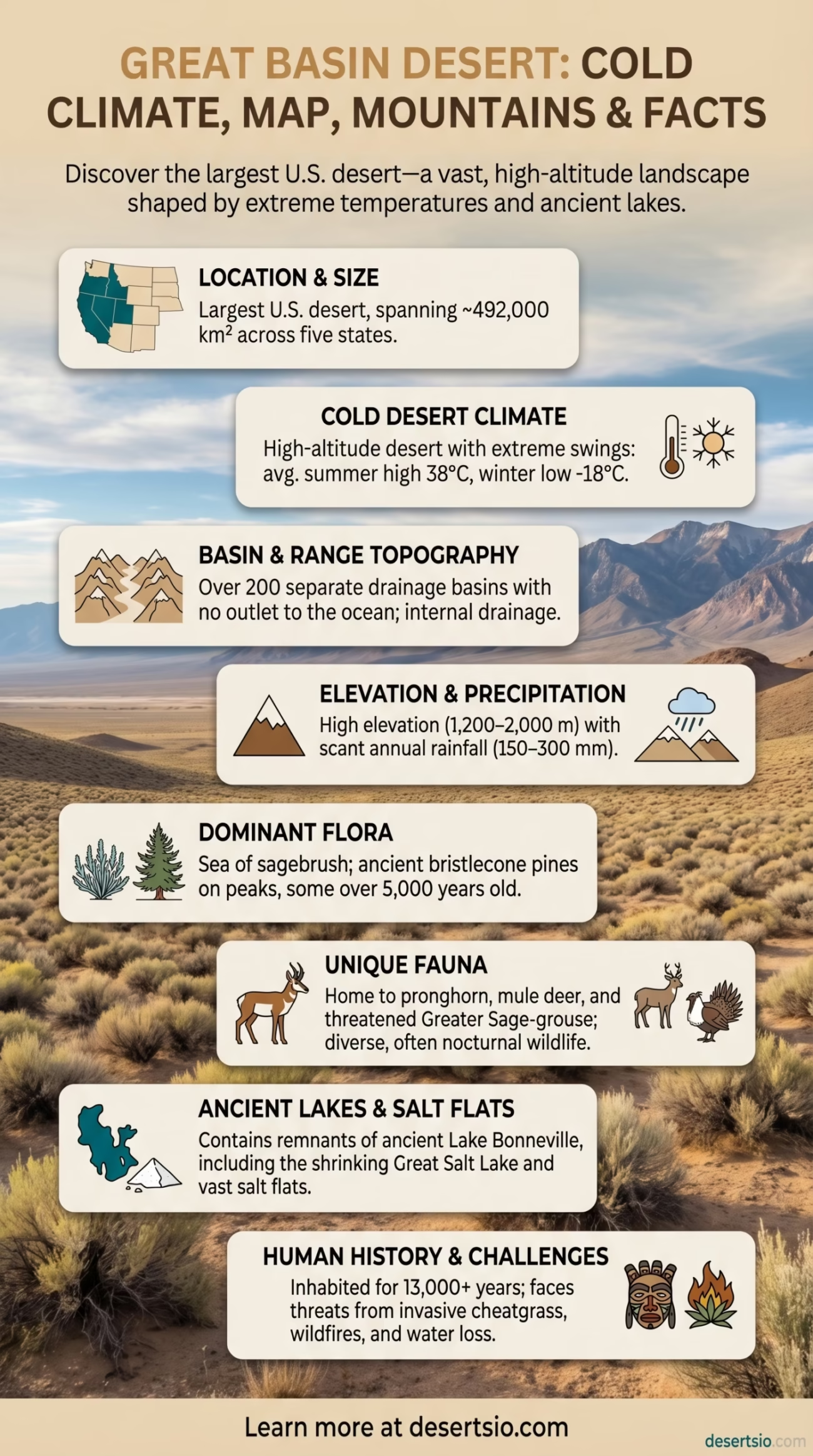
| Location | Western United States — Nevada, Utah, Oregon, Idaho, California |
| Total Area | ~492,000 km² (190,000 sq mi) |
| Desert Type | Cold desert (temperate desert) |
| Elevation Range | 1,200 – 2,000 m (3,900 – 6,600 ft) above sea level |
| Annual Precipitation | 150 – 300 mm (6 – 12 in) per year |
| Average Summer High | 38°C (100°F) |
| Average Winter Low | −18°C (0°F) |
| Dominant Vegetation | Sagebrush (Artemisia tridentata), shadscale, greasewood |
| Major Basins | Over 200 separate drainage basins with no outlet to the ocean |
| Largest Lake | Great Salt Lake (remnant of ancient Lake Bonneville) |
| Protected Areas | Great Basin National Park, Nevada; multiple BLM wilderness areas |
| Human Population | Sparse; major cities include Reno and Salt Lake City on the fringes |
| Indigenous Peoples | Western Shoshone, Northern Paiute, Goshute, Ute |
The Great Basin Desert sits at an average elevation of roughly 1,500 meters — higher than most people imagine when they hear the word “desert.” It stretches across nearly half a million square kilometers, making it the largest desert in the United States and one of the most ecologically distinct arid regions on the planet. Unlike the Sahara or the Sonoran, this is not a land of blazing sand dunes. It is a cold, high-altitude desert shaped by mountain shadows, ancient lakes, and relentless wind.
- How Big Is the Great Basin Desert?
- Great Basin Desert: Location and Map View
- Formation: How This Desert Came to Be
- Temperature: Extreme Swings Between Day and Night
- Flora: A Sea of Sagebrush
- Fauna: More Wildlife Than Most Expect
- Human Life in the Great Basin
- Great Basin vs. Other North American Deserts
- Nearby Deserts and Regional Context
- A Desert Under Pressure: Current Ecological Challenges
- What Makes the Great Basin Scientifically Significant
- Desert Glossary: Key Terms for the Great Basin
How Big Is the Great Basin Desert?
At approximately 492,000 km², the Great Basin Desert is larger than the entire country of Spain (505,990 km² — so, remarkably close). It covers most of Nevada, significant portions of Utah, and extends into southeastern Oregon, southern Idaho, and a sliver of eastern California. To put it another way: you could fit the United Kingdom inside it almost twice over.
The term “basin” is not just geographic poetry. The entire region is internally drained — meaning no river flows out to the ocean. Precipitation that falls here stays here, evaporating or sinking into the ground. Over 200 separate basins create a series of enclosed valleys separated by parallel mountain ranges running roughly north to south. This distinctive basin-and-range topography defines the landscape more than anything else.
Great Basin Desert: Location and Map View
Formation: How This Desert Came to Be
The Great Basin’s aridity is a direct consequence of its position relative to surrounding mountain ranges. The Sierra Nevada to the west and the Cascade Range block moisture-laden air masses moving in from the Pacific Ocean — a process called the orographic rain shadow effect. Air rises over the mountains, loses its moisture as rain or snow, and descends into the basin dry and warm. The Rocky Mountains create a secondary barrier from the east.
Geologically, the basin-and-range structure itself formed through crustal extension — the Earth’s crust stretching and thinning over millions of years, causing alternating fault-block mountains and valleys to rise and sink. This process began roughly 17 million years ago and continues today. The region is seismically active; small earthquakes are common across Nevada and western Utah.
During the last Ice Age (Pleistocene epoch), the Great Basin looked radically different. Lake Bonneville — a massive freshwater lake covering approximately 52,000 km² — dominated what is now western Utah. Its remnant today is the Great Salt Lake, which has shrunk to a fraction of its former size. As of 2023, the Great Salt Lake reached near-record low water levels, dropping to roughly 1,277 meters above sea level, exposing lakebed that generates toxic dust storms affecting millions of people downwind. A stark reminder that this desert’s water history is still being written.
Temperature: Extreme Swings Between Day and Night
This is emphatically not a “warm” desert. The Great Basin is classified as a cold desert — and that classification carries real weight in practice.
- Summer daytime highs: 35–38°C (95–100°F) in valley floors
- Summer nights: Can drop to 10–15°C (50–59°F) — a swing of over 20°C in a single day
- Winter daytime highs: Often below freezing, −5 to 5°C (23–41°F)
- Winter nights: Plunge to −18°C (0°F) or lower at higher elevations
- Annual average temperature: Roughly 8–12°C (46–54°F) depending on elevation and basin
That diurnal temperature range — the gap between daytime high and nighttime low — is one of the defining characteristics of cold deserts globally. Low humidity means heat escapes rapidly after sunset. Travelers who arrive expecting a warm desert night are often genuinely surprised.
Flora: A Sea of Sagebrush
The sagebrush steppe is the dominant ecological community across the Great Basin — and it is, frankly, one of the most underappreciated ecosystems in North America. Artemisia tridentata (big sagebrush) covers vast portions of Nevada and Utah, forming a silvery-gray carpet that stretches to every horizon. The scent after rain is unmistakable — sharp, resinous, almost medicinal.
Beyond sagebrush, the vegetation shifts dramatically with elevation:
- Lower valley floors: Saltbush (Atriplex spp.), greasewood (Sarcobatus vermiculatus), shadscale — salt-tolerant species adapted to alkaline soils
- Mid-elevation slopes: Wyoming big sagebrush, rabbitbrush, bitterbrush (Purshia tridentata)
- Higher elevations (above 2,000 m): Single-leaf pinyon pine (Pinus monophylla) and Utah juniper — the iconic pinyon-juniper woodland
- Mountain peaks: Bristlecone pine (Pinus longaeva) — the oldest living trees on Earth, some exceeding 5,000 years in age
The bristlecone pine deserves special mention. Specimens growing in the White Mountains of eastern California and Nevada’s Snake Range have been documented at over 5,000 years old — predating the Egyptian pyramids. They survive by growing extremely slowly in harsh, rocky, high-altitude conditions.
Fauna: More Wildlife Than Most Expect
The Great Basin supports a surprisingly diverse animal community — though much of it is nocturnal or seasonally active, which makes casual observation difficult.
- Mammals: Pronghorn antelope (the fastest land animal in the Western Hemisphere, reaching 88 km/h), mule deer, coyote, black-tailed jackrabbit, Great Basin kangaroo rat, pygmy rabbit
- Reptiles: Great Basin rattlesnake, Great Basin gopher snake, side-blotched lizard, desert horned lizard
- Birds: Greater sage-grouse (a federally threatened species directly dependent on sagebrush habitat), golden eagle, ferruginous hawk, burrowing owl, loggerhead shrike
- Fish: Several endemic species in isolated spring systems — notably the Devils Hole pupfish (Cyprinodon diabolis), one of the rarest fish on Earth, confined to a single geothermal pool in Nevada
The greater sage-grouse is essentially the ecological indicator species for Great Basin health. Its population has declined by roughly 40% since the 1980s due to sagebrush habitat loss, invasive annual grasses (particularly cheatgrass, Bromus tectorum), and wildfire cycles that are intensifying with climate change.
Human Life in the Great Basin
People have inhabited this desert for at least 13,000 years. The indigenous nations of the Great Basin — primarily the Western Shoshone, Northern Paiute, Goshute, and Southern Paiute — developed sophisticated survival strategies adapted to a landscape of sparse, unpredictable resources.
These were not nomadic peoples wandering randomly. Their seasonal movements followed precise ecological knowledge — pine nut harvests in autumn (pinyon pine seeds were a critical caloric staple), rabbit drives in winter, fishing at marshes in spring. The Numic-speaking peoples of the Great Basin developed an encyclopedic understanding of over 100 edible and medicinal plant species across the sagebrush landscape.
Today, the interior Great Basin remains among the least densely populated regions in the contiguous United States. Esmeralda County, Nevada, for instance, covers over 9,000 km² with fewer than 1,000 residents — roughly one person per 9 km². Most modern population centers — Reno, Salt Lake City, Las Vegas — sit on the desert’s edges rather than its interior.
Great Basin vs. Other North American Deserts
| Desert | Type | Area (km²) | Avg. Annual Rainfall | Dominant Plant |
| Great Basin | Cold desert | ~492,000 | 150–300 mm | Big sagebrush |
| Sonoran Desert | Hot desert | ~310,000 | 75–500 mm | Saguaro cactus |
| Mojave Desert | Hot/transitional | ~124,000 | 25–200 mm | Joshua tree |
| Chihuahuan Desert | Hot desert | ~362,000 | 200–400 mm | Lechuguilla |
What immediately stands out: the Great Basin is the largest of the four by a considerable margin, yet it receives more annual precipitation than the Mojave. The key difference is temperature — cold winters mean evaporation rates are lower, but snow and ice still lock moisture away from vegetation for months at a time. The Sonoran Desert, by contrast, benefits from two separate rainy seasons (winter Pacific storms and summer monsoon), making it the most biologically diverse desert in North America despite being considerably smaller.
Nearby Deserts and Regional Context
The Great Basin does not exist in geographic isolation. It sits within a broader network of arid regions across the American West:
- Mojave Desert — directly to the south, separated roughly by the Spring Mountains of Nevada; hotter, drier, and home to the iconic Joshua tree (Yucca brevifolia). Death Valley, the lowest and hottest point in North America (−86 m / −282 ft; record high 54.4°C / 130°F), sits within the Mojave.
- Sonoran Desert — further south into Arizona and northwestern Mexico; far warmer, with tall columnar cacti and a remarkable monsoon season.
- Columbia Basin — to the north in Washington State; sometimes classified as the northern extension of the cold desert biome, though it receives slightly more rainfall and is officially a semi-arid shrub-steppe rather than a true desert.
- Chihuahuan Desert — southeast across New Mexico and Texas into Mexico; the largest desert in North America if measured by the broadest geographic definitions, and notable for its high diversity of succulent plants.
Of these, the Mojave-Great Basin boundary is the most ecologically interesting transition zone. The presence or absence of Joshua trees is often used as an informal boundary marker. Where sagebrush gives way to Joshua tree woodland, you have effectively crossed from one desert world into another.
A Desert Under Pressure: Current Ecological Challenges
The Great Basin faces a compounding set of environmental pressures — and several are accelerating.
Cheatgrass invasion is arguably the most serious. This annual Eurasian grass, introduced accidentally in the 19th century, now dominates millions of hectares of former sagebrush habitat. It dries out early in summer, creating a dense, continuous fuel layer that carries wildfire faster and hotter than native vegetation ever did. The result: fire return intervals that once measured 60–110 years have collapsed to 5–10 years in heavily invaded areas. Sagebrush cannot regenerate on that timeline. And without sagebrush, sage-grouse, pronghorn, and dozens of other species disappear.
The Great Salt Lake crisis — mentioned earlier — is another signal worth watching. Since the 1980s, the lake has lost approximately 73% of its surface area and 11 meters of depth. Exposed lakebed contains arsenic, mercury, and other heavy metals that wind carries into populated valleys. Estimates suggest that without intervention, the lake could effectively disappear within the next few decades — with cascading effects on regional brine shrimp industries, migratory bird populations (the lake hosts up to 10 million birds annually), and air quality.
And then there is the rapid expansion of utility-scale solar and geothermal energy development across Nevada and Utah. The Great Basin’s wide open, federally managed lands make it attractive for renewable energy projects — which are genuinely important for decarbonization. But large-scale land disturbance in sagebrush desert can be just as damaging to native species as other forms of development. Finding the balance between energy transition and ecosystem conservation is one of the defining land-use debates in the American West right now.
What Makes the Great Basin Scientifically Significant
Few deserts offer the scientific density of the Great Basin. The isolated mountain ranges — called “sky islands” — act as biological laboratories. Species trapped on separate mountain ranges since the last Ice Age have diverged genetically over thousands of years. The region contains an unusually high number of endemic species (found nowhere else on Earth) precisely because its basins are isolated from each other hydrologically and ecologically.
The Bonneville Salt Flats — remnant lakebed of ancient Lake Bonneville — have a different kind of significance: they are among the flattest surfaces on Earth, used for land speed records since 1914. The measured surface deviates by less than 3 inches per mile over 12 miles of racing course.
And the bristlecone pines. Those ancient, wind-sculpted trees at the margins of this desert contain climate data going back 9,000 years — preserved in their growth rings. Dendrochronologists have used Great Basin bristlecone pine data to reconstruct past climate variability with a precision available from almost no other biological source on Earth.
Desert Glossary: Key Terms for the Great Basin
- Endorheic Basin — A closed drainage basin with no outflow to an ocean or sea; all the Great Basin’s water stays within the basin.
- Orographic Rain Shadow — The dry area on the leeward side of a mountain range where precipitation is dramatically reduced.
- Playa — A flat, dry lakebed formed in an endorheic basin; often covered with salt or mineral deposits. Dozens exist across Nevada and Utah.
- Diurnal Temperature Range — The difference between daytime maximum and nighttime minimum temperatures; extreme in cold deserts like the Great Basin.
- Sky Island — An isolated mountain range rising from a desert floor, supporting distinct ecosystems due to their separation from other highlands.
- Cheatgrass (Bromus tectorum) — An invasive annual grass that has altered fire regimes across millions of hectares of Great Basin sagebrush habitat.
