
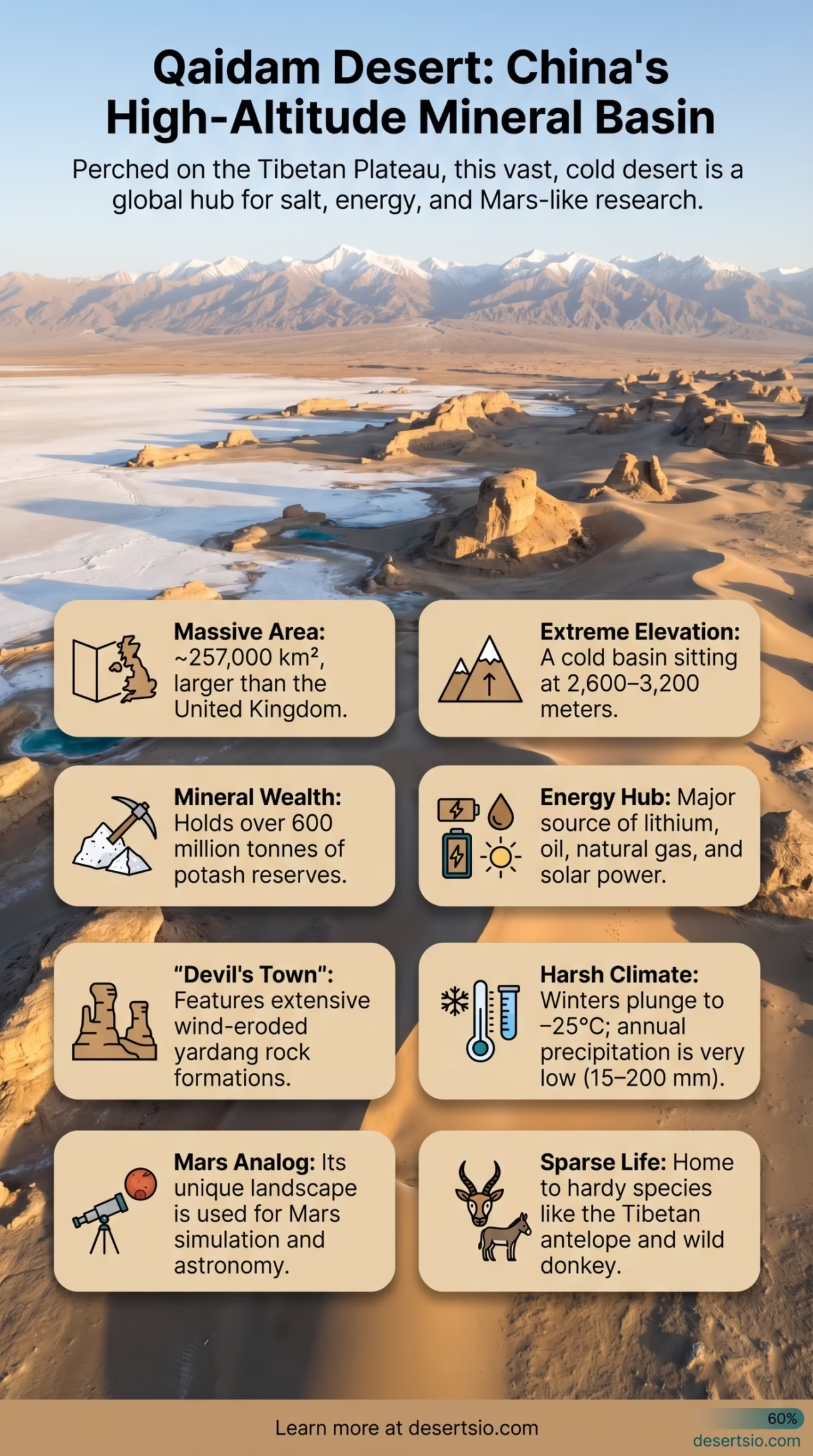
| Location | Qinghai Province, northwestern China |
| Coordinates | 37°N 95°E (approximate center) |
| Area | ~257,000 km² (99,000 sq mi) |
| Size Comparison | Larger than the United Kingdom (243,610 km²) |
| Elevation | 2,600 – 3,200 m above sea level |
| Desert Type | Cold high-altitude basin desert |
| Annual Precipitation | 15 – 200 mm (varies by zone) |
| Average Summer Temperature | Day: 25–30°C / Night: 5–10°C |
| Average Winter Temperature | Day: −5 to −10°C / Night: −20 to −25°C |
| Surrounding Mountains | Kunlun (south), Altun (north), Qilian (northeast) |
| Major Resources | Potash, lithium, salt, oil, natural gas, coal |
| Nickname | “The Devil’s Town” (Yardang landform area) |
| Key River | Golmud River |
| Administrative Center | Golmud City |
The Qaidam Desert sits at an elevation most deserts never reach — perched between 2,600 and 3,200 meters above sea level on the Tibetan Plateau, it occupies a vast tectonic basin that most people outside of China have never heard of. Yet at roughly 257,000 square kilometers, it covers more surface area than the United Kingdom. This is not your typical sand-dune landscape. The Qaidam is a place of salt flats, wind-carved rock formations, and mineral wealth that has quietly shaped modern industry.
Qaidam Desert: Location and Map View
How Did the Qaidam Basin Form?
The word Qaidam comes from the Mongolian Chaidam, meaning “salt marsh” — and the geology tells you exactly why. The basin formed as a result of the collision between the Indian and Eurasian tectonic plates, the same geological event that raised the Himalayas and the Tibetan Plateau. As the surrounding mountain ranges — the Kunlun, Altun, and Qilian — pushed upward over tens of millions of years, the basin floor sank and became enclosed. Without any outlet to the sea, water that collected over millennia gradually evaporated, leaving behind massive salt deposits, mineral brines, and alkaline lake beds that define the Qaidam today.
The process intensified during the Cenozoic era (roughly the last 66 million years), with accelerated subsidence during the Miocene epoch. The basin floor is in places covered by sediment layers up to 10,000 meters deep — an extraordinary geological archive of Central Asian climate history.
Size and Scale: Bigger Than You Think
At 257,000 km², the Qaidam is larger than the entire United Kingdom. To put it another way, it is roughly equivalent to the state of Oregon in the United States. What makes the scale even more striking is the elevation: nearly the entire basin sits above 2,600 meters, making it the highest-altitude desert basin in the world. Tibet gets most of the attention, but the Qaidam quietly holds the record.
The basin stretches approximately 850 km from west to east and around 250–300 km from north to south. Western areas receive as little as 15 mm of annual rainfall, while the eastern edges see closer to 200 mm — still firmly arid by any definition.
Temperature Extremes and Climate
The Qaidam is classified as a cold high-altitude desert. The altitude dictates everything here. Summers are short and relatively mild during the day — temperatures reach 25–30°C in July — but nights can drop sharply to 5–10°C, even in peak summer. That diurnal swing (the day-night temperature gap) regularly exceeds 20°C.
Winters are severe. Daytime highs rarely climb above −5°C between December and February, and nighttime lows can plunge to −25°C. Frost is possible in every month of the year at higher elevations within the basin. The thin atmosphere at altitude means ultraviolet radiation is intense year-round — a less obvious but very real feature of life here.
Qaidam Climate Overview
- Hottest month: July — average daily high ~28°C, average night ~7°C
- Coldest month: January — average daily high ~−8°C, average night ~−22°C
- Annual precipitation: 15–200 mm depending on zone
- Diurnal temperature range: up to 20–25°C in summer
- Sunshine hours: 3,000+ hours per year (one of China’s highest)
- Wind: Dominant from northwest; speeds regularly exceed 100 km/h in spring
The Mineral Wealth Beneath the Salt
This is where the Qaidam becomes genuinely extraordinary. Beneath and within those salt flats lies one of the most mineral-rich basins on Earth. The numbers are staggering:
- Potash reserves: Over 600 million tonnes — the largest known potash deposit in China, critical for fertilizer production
- Salt (NaCl): Estimated at 60 billion tonnes across basin salt lakes
- Lithium: Significant brine lithium reserves, increasingly important for battery technology
- Oil and natural gas: The Qaidam Basin holds proven crude oil reserves of approximately 300 million tonnes and natural gas reserves exceeding 300 billion cubic meters
- Coal: Deposits estimated at over 30 billion tonnes
- Magnesium, boron, strontium in commercially significant concentrations
Qarhan Salt Lake — the largest salt lake in China at 5,856 km² — sits at the heart of the basin and has been mined for potash since the 1950s. The Golmud Potash Plant here is one of Asia’s largest potash producers. And increasingly, the lithium content of the basin’s brine lakes is drawing intense interest in the context of the global electric vehicle industry.
In 2023 and 2024, China significantly expanded lithium extraction operations across the Tibetan Plateau region, including the Qaidam Basin — directly tied to surging demand for EV batteries. The basin is now considered a strategic resource zone at a national level.
Flora and Fauna: Survival at Altitude
Life here is sparse but stubborn. The vegetation cover of the Qaidam is one of the lowest of any desert in China — in the most arid western portions, plant cover falls below 5%. But it exists.
Plants found in the Qaidam include:
- Kalidium foliatum and Haloxylon ammodendron (saxaul) — salt-tolerant shrubs that anchor sandy soils
- Nitraria tangutorum — a thorny shrub forming hummocks in saline ground
- Leymus secalinus and various native grass species in moister eastern zones
- Sparse alpine steppe species near the basin edges at higher elevations
Fauna is similarly resilient. The Tibetan antelope (Pantholops hodgsonii, or chiru) moves through the basin’s eastern margins. Tibetan wild donkeys (kiang) are a more regular presence. Brown bears, wolves, and foxes have been documented in the basin edges. Bird life includes raptors such as the upland buzzard and saker falcon, and the basin’s salt lakes host migratory waterfowl during certain seasons.
The salt flats themselves? Almost nothing survives there. They are, in the truest sense, dead zones.
The Yardang Fields: “The Devil’s Town”
One of the Qaidam’s most visually dramatic features is its yardang landscape — wind-eroded rock formations that locals and visitors have nicknamed Mógui Chéng, or “The Devil’s Town.” Yardangs form when sustained, unidirectional winds carve soft sedimentary rock into elongated ridges and troughs over thousands of years.
The Qaidam yardang field near Lenghu (Cold Lake) covers roughly 350 km² and contains some of the best-preserved yardang formations in the world. Ridges can reach 20–30 meters in height. At night, wind channeling through the formations produces an eerie howling sound — which explains the local name. These formations have also attracted the attention of planetary scientists: NASA and Chinese space researchers have used the Qaidam yardangs as an analog environment for Mars, because the surface conditions — aridity, UV intensity, thin air, and mineral composition — closely resemble certain Martian terrains.
Human Life in the Basin
The Qaidam is not uninhabited — but it has never been densely populated. Historically, Mongolian and Tibetan nomadic groups used the basin’s eastern and southern edges for seasonal grazing. The Mongolian name for the region (Chaidam) reflects centuries of Mongolian presence in this area. Tibetan communities have long regarded certain high-elevation zones near the basin as sacred landscapes connected to the broader Tibetan Plateau spiritual geography.
Today, the dominant settlement is Golmud City (格尔木市), with a population of roughly 200,000 people — an industrial and logistics hub built almost entirely around resource extraction. It is one of the highest-elevation cities in the world at approximately 2,780 meters. The famous Qinghai–Tibet Railway, which connects Xining to Lhasa, passes directly through Golmud, making it a critical node in the supply chain for Tibetan Plateau development.
Beyond Golmud, population is extremely thin. Small settlements exist at Lenghu, Mangya, and Dachaidan — each tied to specific mining or energy operations.
Solar Energy: The Qaidam’s Newest Resource
With over 3,000 sunshine hours per year and vast flat terrain at high altitude, the Qaidam Basin has become one of the world’s most important locations for solar energy development. The Golmud Solar Park, once the largest solar installation in the world when it was first expanded in 2013, remains one of the largest in China. The Qaidam Basin now hosts multiple gigawatt-scale solar farms across its flat terrain.
And this is directly connected to the lithium story. Mine lithium from the salt brines, power the extraction and processing with solar energy, use the lithium to build batteries for electric vehicles. The Qaidam Basin is, quietly, at the center of a very modern supply chain.
Nearby Deserts and Regional Context
The Qaidam does not exist in isolation. It sits within a broader network of arid landscapes across Central and East Asia.
| Desert / Arid Region | Location | Area | Key Similarity to Qaidam |
| Gobi Desert | Mongolia / northern China | ~1,300,000 km² | Cold desert, mineral resources, high plateau |
| Taklamakan Desert | Xinjiang, China | ~337,000 km² | Enclosed basin, arid, sand dunes, resource extraction |
| Kumtag Desert | Xinjiang / Gansu border | ~22,800 km² | Adjacent region, wind-formed terrain |
| Tibetan Plateau Steppe | Tibet / Qinghai | >1,000,000 km² | High altitude, cold, similar fauna (chiru, kiang) |
The Taklamakan Desert to the northwest is the most direct geographic neighbor — separated from the Qaidam by the Altun Mountains. Both are enclosed basins with minimal drainage to the sea, both are intensely arid, and both sit atop significant hydrocarbon reserves. The key difference: the Taklamakan is a sea of shifting sand dunes at lower elevation, while the Qaidam is dominated by salt flats and rocky desert at extreme altitude.
The Gobi Desert, further northeast, shares the cold desert classification and the mineral wealth story but is spread across a far larger and more varied terrain. The Qaidam, by comparison, is more geologically uniform — a single enclosed basin with a coherent mineral signature throughout.
Desertification Pressures
Despite its remote location, the Qaidam is not immune to desertification pressures. Sand encroachment on the eastern basin edges has accelerated in recent decades, linked to overgrazing, groundwater extraction, and regional climate shifts. Studies published by Chinese Academy of Sciences researchers indicate that mobile sand dunes in the eastern Qaidam expanded by approximately 12–15% between 1975 and 2015.
Vegetation rehabilitation projects using saxaul planting have been deployed along key transport corridors. The challenge is real: restoring vegetation in a basin where annual rainfall can be as low as 15 mm requires both patience and significant investment. The results have been mixed, but measurable in localized areas near Golmud.
A Mars Analog in Qinghai
It is worth dwelling on the Mars analog aspect — because it is genuinely unusual. The Chinese National Space Administration has identified specific sites within the Qaidam Basin, particularly near Lenghu, as Mars simulation zones. In 2021, the Lenghu Mars Simulation Base officially opened, offering a location where the surface terrain, soil chemistry, UV radiation, atmospheric thinness (relative to lower elevations), and visual appearance all approximate what robotic missions have documented on Mars.
The region around Lenghu also turns out to have exceptional astronomical seeing conditions — low humidity, high altitude, minimal light pollution — leading to the establishment of a major astronomical observatory complex there. A 2021 study in Nature identified the Lenghu plateau as one of the best observatory sites in the Northern Hemisphere. The desert’s harshness, paradoxically, makes it ideal for science.
Qaidam Desert: Key Terms Worth Knowing
- Yardang: Wind-eroded ridge of rock or sediment, elongated in the direction of prevailing winds
- Playa / Salt flat: Dry lake bed coated in mineral salts; the Qaidam contains dozens of active and fossil playas
- Brine lake: A highly saline body of water; Qaidam’s brine lakes are the source of lithium and potash extraction
- Chiru (藏羚羊): Tibetan antelope; an iconic high-altitude mammal found on Qaidam’s fringes
- Golmud (格尔木): The main city of the basin; its name derives from the Mongolian word for “river”
- Saxaul (Haloxylon): A hardy desert shrub crucial for sand stabilization across Central Asian deserts
The Qaidam Basin is worth a closer look. It is, on the surface, one of the most forbidding landscapes on Earth — cold, windswept, saline, and remote. But beneath that surface, and increasingly above it (in the form of solar panels and telescope domes), it has become an important area for 21st-century science and industry. Few deserts anywhere combine these roles.