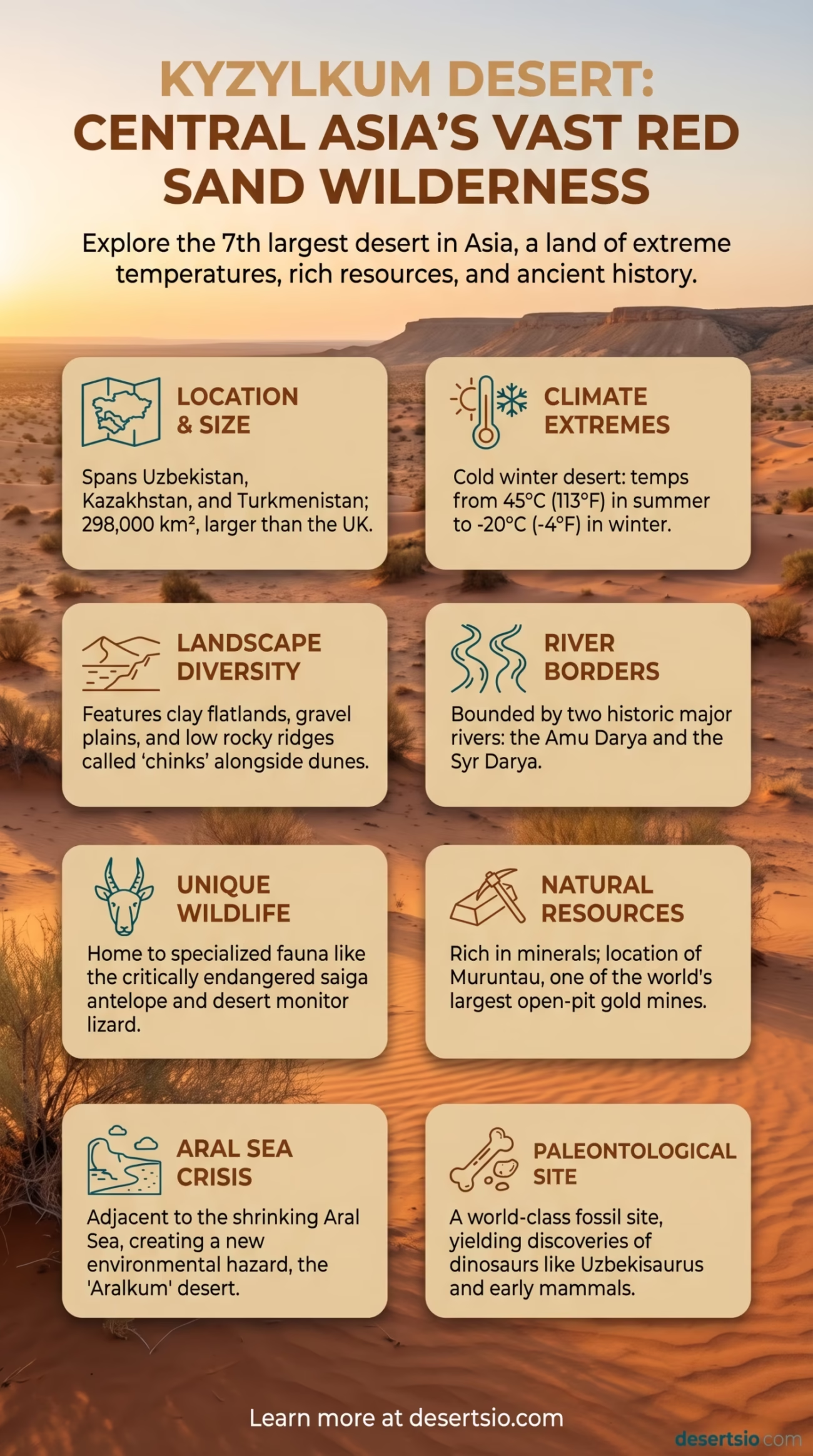
| Location | Central Asia — Uzbekistan, Kazakhstan, and a small portion of Turkmenistan |
| Area | Approximately 298,000 km² (115,000 sq mi) |
| Type | Cold winter desert (semi-arid) |
| Average Elevation | 100–300 m above sea level |
| Daytime Temperature (Summer) | Up to 45°C (113°F) |
| Nighttime Temperature (Winter) | As low as −20°C (−4°F) |
| Annual Precipitation | 100–200 mm per year |
| Major Rivers (Bordering) | Amu Darya and Syr Darya |
| Dominant Landscape | Sandy plains, saxaul forests, clay flatlands, isolated hills (chinks) |
| Name Meaning | “Red Sand” in Uzbek and Kazakh |
| Natural Resources | Natural gas, gold, uranium, copper |
| Notable Feature | Muruntau Gold Mine — one of the largest open-pit gold mines on Earth |
The name says it all — Kyzylkum translates to “Red Sand” in both Uzbek and Kazakh, and anyone who has studied satellite imagery of Central Asia will immediately understand why. Stretching across nearly 298,000 square kilometers, this vast desert dominates the land between two of the most historically significant rivers in the ancient world: the Amu Darya and the Syr Darya. It is the seventh largest desert in Asia and one of the most geologically complex arid regions on the planet.
Most people think of deserts as purely lifeless wastelands. Kyzylkum challenges that assumption at every turn.
Kyzylkum Desert: Location and Map View
How Big Is the Kyzylkum Desert?
At 298,000 km², the Kyzylkum Desert is larger than the entire United Kingdom — which covers roughly 243,000 km². To put it another way, you could fit the state of Arizona inside it and still have room left over. The desert spans three countries: the majority lies within Uzbekistan and Kazakhstan, with a narrow strip touching Turkmenistan in the southwest.
The terrain is not uniform. Sandy dunes (locally called barchans) cover only a portion of the landscape. Much of the interior consists of clay flatlands, gravel plains, and low rocky ridges called chinks — elevated plateaus with dramatic eroded edges. The highest point in the desert is Mount Sultanuizdag, rising to about 922 meters in Uzbekistan’s section of the desert.
Formation: How Did Kyzylkum Come to Be?
The Kyzylkum Desert sits within the Turan Depression, a vast ancient lowland that was once covered by the Tethys Sea millions of years ago. As tectonic activity continued and the sea retreated, the exposed basin gradually dried. The surrounding mountain ranges — the Tian Shan to the east and the Pamir-Alay to the south — create a powerful rain shadow effect, blocking moisture-laden air from reaching the interior.
Over millennia, wind erosion and fluvial processes (shaped by the ancient courses of the Amu Darya and Syr Darya) sculpted the reddish sandy terrain that defines the desert today. The red and orange coloration of the sand comes from iron oxide (rust) particles mixed into the quartz grains — a detail that gives the desert both its name and its unmistakable visual identity.
And that iron-rich soil? It also hints at the enormous mineral wealth hidden beneath the surface.
Temperature: A Desert of Extremes
Unlike the Sahara, which stays warm year-round, Kyzylkum is classified as a cold winter desert. The temperature swings here are genuinely dramatic — not just between seasons, but between a single morning and afternoon.
- Summer daytime temperatures: Regularly exceed 40°C (104°F), with peaks reaching 45°C (113°F)
- Summer nights: Drop sharply to around 20–25°C — a 20-degree swing in a matter of hours
- Winter daytime temperatures: Hover around 0–5°C (32–41°F)
- Winter nights: Plunge to −20°C (−4°F) or lower in severe cold spells
- Annual rainfall: Between 100 and 200 mm, falling mostly in winter and early spring
The wind is a constant presence. Local winds — particularly the afganets, a hot, dry wind blowing from the south — can dramatically accelerate sand movement and cause severe dust storms. This phenomenon affects agriculture and infrastructure in the surrounding regions significantly.
Flora and Fauna: More Life Than You’d Expect
Kyzylkum is not barren. Far from it. The desert supports a surprisingly diverse range of plant and animal life, much of it highly specialized for surviving brutal temperature extremes and minimal water.
Plant Life
The dominant plant of the Kyzylkum is the saxaul tree (Haloxylon ammodendron), a drought-resistant woody plant that stores water in its spongy trunk. Saxaul forests — though sparse — help stabilize shifting sands and serve as habitat for numerous species. Other notable vegetation includes:
- Salsola (saltwort) species, thriving in saline soils
- Calligonum — a leafless shrub with striking coral-like branches
- Ephemeral grasses and wildflowers that bloom explosively after spring rains, then disappear
- Tamarisk (Tamarix) species along dry riverbeds
Animal Life
The Kyzylkum supports a remarkable fauna. The saiga antelope (Saiga tatarica) is perhaps the most iconic — and tragically endangered — resident. This prehistoric-looking creature with its distinctive bulbous nose has roamed Central Asian steppes and desert margins for thousands of years. Saiga populations have declined by over 95% since the 1970s due to habitat loss and poaching, making conservation efforts in the Kyzylkum region critically important.
Other notable animals include:
- Tolai hare — smaller than European rabbits, perfectly camouflaged in sandy terrain
- Varanus griseus — the desert monitor lizard, Central Asia’s largest reptile, reaching up to 1.6 meters
- Caspian cobra (Naja oxiana) — one of the most venomous snakes in Asia
- Numerous species of gerbils and jerboas, nocturnal rodents that avoid daytime heat
- The Bukhara deer (Bactrian deer), found near river delta zones
- Various raptor species including eagles, falcons, and harriers that hunt over open ground
Human Life in the Kyzylkum
People have lived in and around the Kyzylkum for at least 3,000 years. The desert was never a true barrier — it was a highway. Ancient Silk Road trade routes passed through its edges, connecting the great oasis cities of Samarkand, Bukhara, and Khiva to markets stretching from China to the Mediterranean.
Today, the desert’s population is sparse but not absent. Karakalpakstan — an autonomous republic within Uzbekistan — borders the northern Kyzylkum and is home to the Karakalpak people, a Turkic ethnic group with their own language and rich nomadic heritage. Traditional practices of yurt-dwelling, camel herding, and carpet weaving persist in rural communities, though modern sedentary settlements have largely replaced historical nomadic patterns.
Small settlements are scattered throughout the desert, most clustered near water sources or along roads serving the mining industry. The Navoi region — a major industrial hub built around natural resource extraction — sits at the heart of the desert. Population density across the Kyzylkum averages fewer than 3 people per km².
Natural Resources and Industry
The Kyzylkum’s economic importance goes far beyond its surface. The desert sits atop extraordinary mineral reserves that have made it one of Central Asia’s most strategically important regions.
- Gold: The Muruntau Gold Mine in Uzbekistan is one of the largest open-pit gold mines in the world, producing over 60–70 tonnes of gold annually. The deposit was discovered in 1958 and remains in active operation today.
- Natural Gas: Significant natural gas fields lie beneath the desert, contributing to both Uzbekistan’s and Kazakhstan’s energy sectors.
- Uranium: Kyzylkum contains commercially viable uranium deposits, placing Uzbekistan among the world’s top 10 uranium producers.
- Copper and Tungsten: Additional metallic ore deposits have been identified and partially developed across the desert’s territory.
The Aral Sea Crisis: A Shadow Over the Desert
No discussion of Kyzylkum is complete without mentioning the Aral Sea catastrophe. The Aral Sea — once the world’s fourth-largest lake — bordered the northern edges of the Kyzylkum. Beginning in the 1960s, large-scale irrigation projects diverted water from the Amu Darya and Syr Darya (the very rivers that border Kyzylkum) to cotton fields across Central Asia.
The result was catastrophic. By 2007, the Aral Sea had shrunk to roughly 10% of its original size. The exposed seabed — now called the Aralkum — created a new desert of salt and toxic dust, adding thousands of square kilometers of degraded land adjacent to the Kyzylkum. Dust storms from the dried seabed now carry salt and pesticide residues across the region, affecting air quality and agriculture as far as 500 km away.
This is one of the major environmental disasters of the 20th century. Ongoing regional cooperation — including the work of the International Fund for Saving the Aral Sea (IFAS) — continues to address the consequences, though full recovery is considered impossible.
Nearby Deserts and Regional Context
The Kyzylkum does not exist in isolation. Central Asia is home to several major arid regions, and understanding the Kyzylkum means placing it within this broader desert landscape.
| Desert | Location | Area | Key Difference from Kyzylkum |
| Karakum Desert | Turkmenistan | ~350,000 km² | Slightly larger; home to the famous Darvaza Gas Crater; also cold winter desert |
| Taklamakan Desert | China (Xinjiang) | ~337,000 km² | More extreme dune coverage; higher dunes up to 300 m; more isolated |
| Gobi Desert | China / Mongolia | ~1,295,000 km² | Much larger; colder winters; significant paleontological significance |
| Ustyurt Plateau | Kazakhstan / Uzbekistan | ~200,000 km² | Adjacent plateau desert; dramatic cliff edges; considered a separate formation |
The Karakum (meaning “Black Sand”) is Kyzylkum’s closest sibling — geographically, climatically, and historically. Both deserts share similar formation processes, similar cold-winter temperature profiles, and borders with the same rivers. If Kyzylkum is the red desert of the north, Karakum is its dark-toned counterpart to the south.
A Desert With a Fossil Record
One aspect of Kyzylkum that rarely makes headlines: it is a world-class paleontological site. The ancient sedimentary layers of the desert — deposited during the Jurassic and Cretaceous periods — have yielded remarkable dinosaur fossils. The Dzharakuduk locality in Uzbekistan, located within the Kyzylkum, has produced fossils of theropod dinosaurs, early mammals, and ancient fish species that lived when this region was a lush coastal environment millions of years ago.
Species like Uzbekisaurus (a large sauropod) were first described from specimens found here. This makes Kyzylkum not just a present-day ecological zone, but also a window into deep geological time.
Desertification and Climate Change Pressures
The boundaries of the Kyzylkum are not static. Desertification — the process by which fertile land degrades into desert — continues to push the desert’s edges outward, driven by both human activity and shifting climate patterns. According to regional environmental assessments, approximately 80% of Central Asian drylands show signs of land degradation.
Rising temperatures — consistent with global climate trends — are accelerating evaporation rates and reducing the effectiveness of seasonal rainfall. The saxaul reforestation programs currently underway in Uzbekistan and Kazakhstan represent one of the most ambitious ecological restoration efforts in Central Asia, with millions of saxaul seedlings planted across degraded desert margins and the former Aral Sea bed.
As of recent years, Uzbekistan has committed to planting saxaul across 1.5 million hectares of the former Aral Sea floor — a scale that, if successful, would represent one of the largest dryland reforestation projects in human history.
Desert Glossary: Key Kyzylkum Terms
- Barchan: A crescent-shaped sand dune formed by wind; common in the Kyzylkum’s sandy zones
- Chink: A steep-edged elevated plateau typical of Central Asian desert topography
- Saxaul: The hardy, water-storing tree that anchors sand and supports desert ecosystems
- Afganets: A hot, dry wind from the south that drives dust storms across the desert
- Aralkum: The newly formed desert on the former Aral Sea bed, adjacent to Kyzylkum
- Takyr: Flat, hardened clay surfaces that appear after seasonal flooding — found across the desert interior