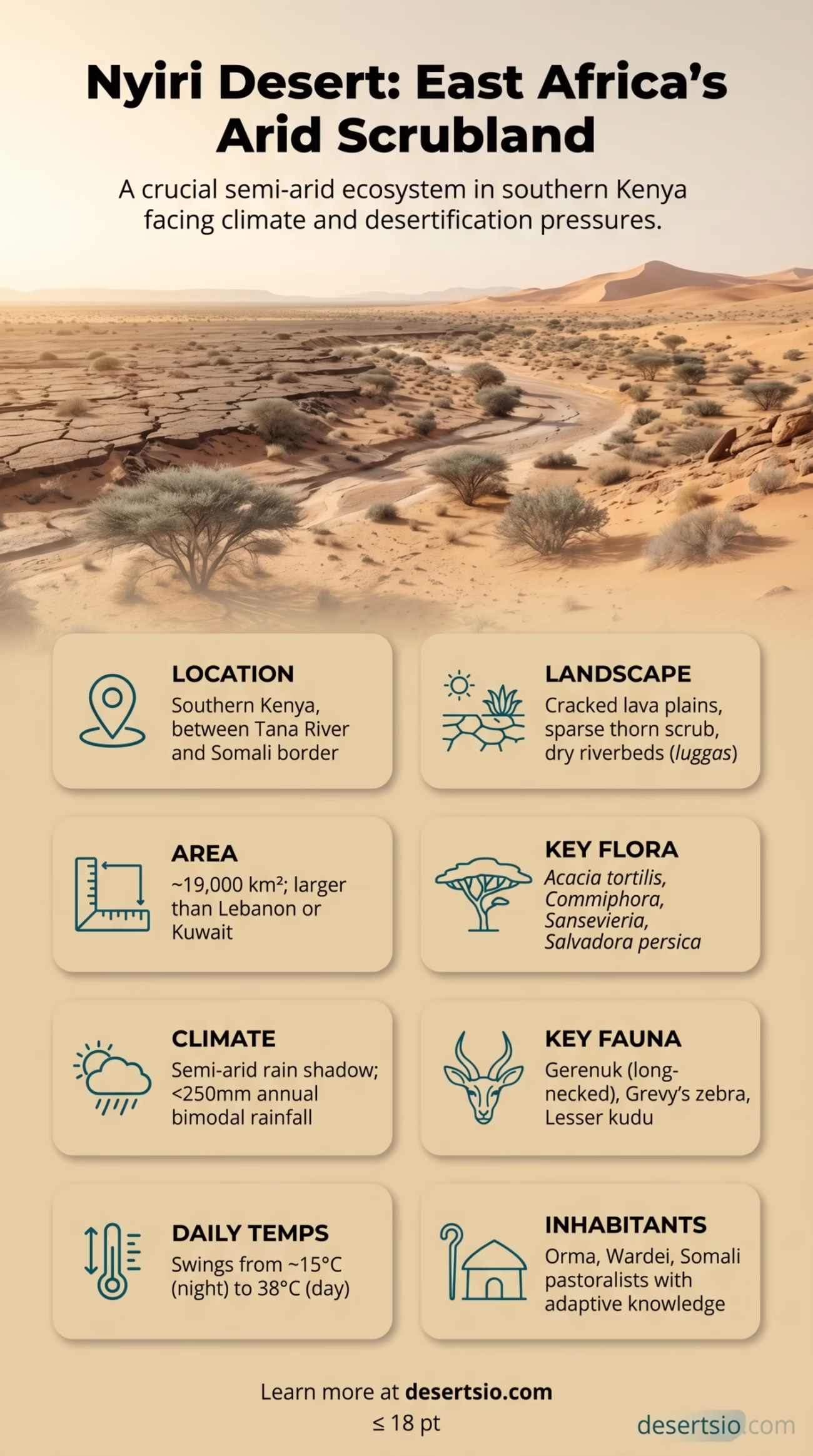
| Location | Southern Kenya, East Africa |
| Area | Approximately 19,000 km² (7,340 sq mi) |
| Country | Kenya |
| Type | Semi-arid desert / Arid scrubland |
| Elevation | Roughly 500–700 m (1,640–2,300 ft) above sea level |
| Average Annual Rainfall | Less than 250 mm (9.8 in) per year |
| Daytime Temperature | Up to 38°C (100°F) |
| Nighttime Temperature | Can drop to 15°C (59°F) |
| Dominant Landscape | Lava plains, thorn scrub, dry riverbeds (luggas) |
| Major River | Tana River (borders the region) |
| Primary Inhabitants | Orma, Wardei, and Somali pastoralist communities |
| Notable Wildlife | Gerenuk, lesser kudu, Grevy’s zebra, ostrich, vultures |
| Nearest Major City | Garissa (~200 km northeast) |
The Nyiri Desert — also spelled Nyiri or sometimes referred to as the Nyika Desert — sits in the southeastern corner of Kenya, tucked between the Tana River basin and the dry thornbush stretches that push toward the Somali border. It is not the kind of place that appears on mainstream desert lists. No sweeping dunes, no cinematic emptiness. Instead: cracked lava plains, sparse grey-green scrub, and a heat that presses down from above and radiates back up from the ground simultaneously.
Nyiri Desert: Location and Map View
At roughly 19,000 square kilometers, the Nyiri Desert is smaller than many of Africa’s better-known arid zones — but size is not the main point. For context, that’s approximately the size of Kuwait, or about half the area of Switzerland. Not vast by Saharan standards, but large enough to influence the lives of communities within and around it.
How Did the Nyiri Desert Form?
The Nyiri’s aridity is the result of several overlapping geological and climatic forces working across millennia. The region sits in what geographers call a rain shadow zone — moisture-laden winds from the Indian Ocean largely exhaust their rainfall over the Kenyan highlands before reaching this southeastern lowland. What arrives here is dry, warm air with little capacity to precipitate.
Beneath the surface, ancient volcanic activity left much of the terrain covered in basaltic lava flows, which hold almost no water and reflect heat with remarkable efficiency. These lava plains — locally known as the nyika (a Swahili and Bantu term broadly meaning “wilderness” or “uninhabited bush”) — bake under the equatorial sun. Soils are shallow, rocky, and largely infertile. Water, when it does fall, drains quickly or evaporates before plants can fully exploit it.
Long-term climate patterns also play a role. East Africa’s bimodal rainfall system — short rains in October–November, long rains in March–May — delivers inconsistent and often below-average totals to this region. Annual rainfall rarely exceeds 250 mm, well below the 500 mm threshold that typically supports stable dryland farming.
Size in Perspective
19,000 km² sounds abstract. Think of it this way: the Nyiri Desert is larger than the entire country of Lebanon and roughly four times the size of the Greater London area. Within Africa, it is dwarfed by the Sahara or the Kalahari — but it is larger than the Namib Desert’s most hyperarid core. It is a meaningful arid zone, not a footnote.
And the desert doesn’t exist in isolation. It bleeds into the broader Northern Frontier District arid belt — a vast arc of semi-desert that stretches from northeastern Kenya deep into Ethiopia and Somalia. The Nyiri is essentially the southern edge of this much larger continental dry zone.
Temperature: Day and Night
Daytime temperatures in the Nyiri regularly climb past 35°C (95°F), with peaks touching 38°C (100°F) during the hottest months (January–February and September). The lava rock amplifies ground-level heat through thermal radiation — standing barefoot on the surface at midday is genuinely dangerous.
Nights are a different story entirely. Temperatures can fall to 15°C (59°F), sometimes lower at higher elevations. That’s a daily swing of up to 23°C (41°F) — a pattern typical of arid regions where low atmospheric humidity prevents the ground from retaining warmth after sunset. Communities here are very familiar with this rhythm: mornings cool and manageable, afternoons brutal, evenings a brief relief.
Nyiri Desert: Temperature Overview
| Hottest Months | January–February, September |
| Peak Daytime High | ~38°C (100°F) |
| Average Daytime (dry season) | 33–36°C (91–97°F) |
| Nighttime Low | ~15°C (59°F) |
| Daily Temperature Swing | Up to 23°C (41°F) |
| Coolest Period | June–July (relative cooling, 20–28°C days) |
Flora and Fauna: Life in the Scrub
Vegetation here is sparse — but it is far from absent. The Nyiri supports a distinct dryland flora adapted to periodic drought and thin soils. Key plant communities include:
- Acacia tortilis (umbrella thorn acacia) — the region’s architectural species, providing shade, browse for livestock, and nesting sites for birds
- Commiphora species (myrrh relatives) — drought-deciduous shrubs with waxy stems that minimize water loss
- Sansevieria (desert sansevierias) — succulent ground-level plants with deep root systems
- Salvadora persica (toothbrush tree / mswaki in Swahili) — a culturally significant shrub used in oral hygiene practices across East Africa
- Dry-season grasses including Cenchrus ciliaris and Eragrostis species that green briefly after rains
Wildlife in the Nyiri is specialized. The most iconic resident is perhaps the gerenuk (Litocranius walleri) — a long-necked antelope that stands on its hind legs to browse acacia leaves, needing almost no standing water. It is practically built for this landscape.
Other notable fauna:
- Grevy’s zebra — one of the world’s most endangered equids, with populations in northern Kenya including the Nyiri fringe
- Lesser kudu — elusive and cryptically patterned, adapted to dense thornbush
- Ostrich — thriving in open lava flats
- Martial eagle, lappet-faced vulture — apex avian predators
- Reticulated giraffe — occasionally seen along the northern borders
- Dikdik (Madoqua spp.) — tiny antelope perfectly scaled for dense thicket habitats
Reptile diversity is high, as expected in any hot, rocky dryland — monitor lizards, agamas, and several species of sand snake are common. What the Nyiri lacks in megafauna spectacle, it compensates with remarkable ecological specificity. Every species here earned its place.
Human Life: The People of the Nyiri
This is not empty land. It never has been.
The Nyiri Desert and its surrounding semi-arid margins are home to several pastoralist communities who have navigated this environment for centuries. The Orma — a Cushitic-speaking people related to the Oromo — are among the most historically rooted groups in the Tana River region adjacent to the desert. Their cattle-herding traditions are finely calibrated to the region’s seasonal water availability, moving herds between permanent water sources (tula) and temporary grazing grounds after rains.
The Wardei, another pastoralist group, occupy overlapping rangelands and have historically managed complex, unwritten agreements about grazing territory — a system that modern land tenure frameworks have sometimes disrupted rather than supported.
Somali pastoralists also move through the eastern Nyiri margins, particularly during drought years when they push further south in search of water and grass. This movement — entirely rational from a survival standpoint — occasionally creates pressure on shared resources and has become a more visible dynamic as climate variability intensifies across the Horn of Africa.
Population density is very low — often fewer than 5 people per km² across the driest zones. But the communities present are not marginal; they represent deeply sophisticated ecological knowledge systems built over generations of living with aridity.
Desertification and Climate Pressure
The Nyiri is not static. Its boundaries shift — and in recent decades, they have been shifting outward.
Desertification is accelerating in Kenya’s arid and semi-arid lands (ASALs), which already cover roughly 80% of Kenya’s total land area and support about 25% of the national population. The Nyiri sits at the core of this pressure zone. According to Kenya’s National Drought Management Authority (NDMA), the region has experienced increasing drought frequency — cycles that previously occurred every 10 years now arrive every 3–5 years.
The 2022 Horn of Africa drought — described by meteorologists as the worst in 40 years — hit the communities around the Nyiri with particular force. Livestock mortality was catastrophic in several counties. Garissa, the nearest major urban center, recorded rainfall deficits exceeding 60% below long-term averages during that period.
Overgrazing compounds the issue. With traditional mobility patterns constrained by fencing, roads, and settlement expansion, livestock concentrate in smaller areas — degrading vegetation cover and accelerating soil erosion. The feedback loop between land degradation and climatic stress is now well-documented and, frankly, difficult to reverse quickly.
Neighboring Deserts and Arid Zones
The Nyiri does not stand alone as an arid landform in this part of Africa. It connects to — and shares characteristics with — several neighboring dry regions:
Chalbi Desert
Located in northern Kenya near Lake Turkana, the Chalbi is Kenya’s most hyperarid desert — a salt flat environment dramatically different from Nyiri’s lava scrub. Annual rainfall drops below 100 mm. The two share climatic drivers but present entirely different landscapes.
Ogaden (Ethiopian Somali Plateau)
North of the Nyiri, the Ogaden region of Ethiopia merges into similar semi-arid scrubland. Shared pastoralist cultures, shared drought cycles, and similar vegetation — these two zones function almost as a continuous arid corridor from a ecological standpoint.
Kaisut Desert
A smaller arid basin in Kenya’s Marsabit County — geologically distinct but climatically aligned with the Nyiri. The Kaisut sits at higher elevation and supports Samburu and Rendille pastoralists in patterns that closely mirror those of Nyiri communities.
Karoo (South Africa)
A useful comparative case — also a semi-arid to arid basin on ancient geology, with similar daily temperature swings and scrubland vegetation. The Karoo averages 150–300 mm of annual rain, comparable to the Nyiri. Both regions face growing desertification pressure tied to overgrazing and climate shifts.
The Luggas: Dry Rivers That Actually Work
One of the Nyiri’s most important hydrological features is its network of luggas — seasonal, often dry riverbeds that channel flash flood water after heavy rain events. These are not merely geographic curiosities. Luggas are critical water infrastructure for both wildlife and communities.
After rain, luggas fill rapidly and then drain — leaving subsurface moisture that supports vegetation for weeks or months afterward. Communities dig shallow wells in lugga beds (sometimes just 1–2 meters deep) to access this water. Acacia groves concentrate along lugga margins, creating linear oasis corridors across an otherwise barren landscape. And some luggas feed into the Tana River, which forms the effective southwestern boundary of the Nyiri’s driest zone.
Understanding luggas is understanding the desert’s pulse. They are why the Nyiri is survivable. Barely — but survivable.
Economic Activity and Livelihoods
Pastoralism dominates. Cattle, camels, goats, and sheep are the economic foundation for most households in and around the Nyiri. Camels, in particular, are vital to livelihoods — more drought-tolerant than cattle, able to travel longer distances between water sources, and providing milk even during dry periods. A single well-adapted camel herd can sustain a family through conditions that would devastate a cattle-dependent household.
Charcoal production — though environmentally damaging — is a significant cash income source for poorer households, contributing to ongoing vegetation loss. And charcoal trade in Kenya’s arid counties has been a persistent policy challenge; government restrictions are difficult to enforce across this scale of territory.
Small-scale trade along the Garissa–Tana River corridor and artisanal fishing on the Tana itself also contribute to local economies. These are not wealthy communities by most measures — Tana River and Garissa counties consistently rank among Kenya’s lowest on human development indices — but they are economically active, resourceful, and deeply tied to the landscape they inhabit.
A Glossary of Key Terms
Nyika — A Swahili/Bantu term for uninhabited wilderness or thorny scrubland; the root word from which “Nyiri” likely derives.
Lugga — A seasonal dry riverbed or ephemeral watercourse, common across Kenya’s arid north and east; critical for subsurface water access.
ASAL — Arid and Semi-Arid Lands; a Kenyan policy classification covering areas with less than 500 mm annual rainfall, comprising ~80% of Kenya’s territory.
Bimodal rainfall — A seasonal pattern with two distinct rainy periods per year; characteristic of equatorial East Africa.
Gerenuk — (Litocranius walleri) A specialist browsing antelope native to East African semi-desert; distinguishable by its exceptionally long neck and ability to stand bipedally to reach high vegetation.
Tula — A permanent water source used as a dry-season focal point in Orma pastoralist resource management systems.
Why the Nyiri Deserves More Attention
East Africa’s lesser-known deserts often get overlooked — the Sahara absorbs global attention, the Namib attracts photographers, and the Kalahari has its documentaries. The Nyiri is a living semi-arid system under active stress, inhabited by communities with practical adaptive knowledge, and affected by climate change, land degradation, and development policy in one of the world’s most vulnerable regions.
The gerenuk standing on its hind legs in the lava scrub, the lugga that holds water six weeks after the last rain, the Orma herder who reads soil color to judge grazing potential — these are not exotic footnotes. They are sophisticated, functional responses to a genuinely difficult environment. And that environment, right now, is changing faster than at any point in recorded history.
The Nyiri is small by global desert standards. Its story, though, is anything but.