A desert is not “a place with lots of sand.” It’s a landscape defined by extreme dryness, where evaporation usually outpaces precipitation. That single idea flips the map in a fun way: the planet’s biggest deserts include ice-covered polar regions as well as sunlit subtropical expanses. If you’re here for the largest deserts in the world, you’re in the right place—this guide focuses on size, how that size is measured, and what makes each giant desert feel so distinct.
- Understanding What A Desert Is
- How Desert Size Is Measured
- The Largest Deserts In The World By Area
- Why Polar Deserts Take The Top Spots
- Hot/Subtropical Deserts
- Cold/Winter Deserts
- Antarctic Desert
- Arctic Desert
- Sahara Desert
- Arabian Desert
- Gobi Desert
- Kalahari Desert
- Patagonian Desert
- Great Basin Desert
- Australia’s Big Desert Mosaic
- Great Victoria Desert
- Simpson Desert
- Other Notably Large Deserts Worth Knowing
- Landforms That Show Up Again And Again In Giant Deserts
Understanding What A Desert Is
Deserts are best understood as an “aridity zone,” not a temperature zone. Some deserts are warm, some are cool, and some stay cold most of the year. What they share is a moisture budget that leans dry—often far drier than many people imagine. When you see the phrase largest desert, it’s really shorthand for “largest region that consistently behaves like a desert.”
Many references use a simple rainfall rule of thumb—often around 250 mm (10 inches) of precipitation per year or less. Scientists also look at how quickly water would evaporate if it were available, which helps explain why a place can be desert-like even with occasional snow or fog. It’s a bit like calling a sponge “dry” not because it never touched water, but because it can’t hold onto it.
How Desert Size Is Measured
Measuring a desert’s area sounds simple until you zoom in. Desert boundaries can shift gradually, and different datasets draw lines in slightly different places. That’s why you’ll sometimes see the same desert listed with slightly different totals. The good news: the biggest deserts remain the biggest, even when the numbers wiggle a little.
- Aridity: Low precipitation relative to evaporation potential.
- Boundary Definitions: Some maps include transitional semi-arid margins; others keep a tighter core.
- Seasonality: A region may be dry year-round or dry most of the year with brief wetter windows.
- Surface Type: Sand seas, rock plateaus, salt flats, ice sheets—none are required, but they shape how the desert is mapped.
One more helpful idea: “desert” is a climate label. Think of it like a jacket size—large, medium, small—rather than a fabric type. A desert can be rocky, sandy, icy, or even dotted with hardy shrubs. The climate is the label; the scenery is the personality.
The Largest Deserts In The World By Area
The list below uses widely cited approximate areas. Values can vary by mapping method, especially along the edges, so treat these as best-fit figures rather than laser-etched constants.
| Rank | Desert | Approx. Area (km²) | Desert Type | Signature Look |
|---|---|---|---|---|
| 1 | Antarctic Desert | 14,200,000 | Polar | Vast ice sheet, dry valleys, wind-sculpted snow |
| 2 | Arctic Desert | 13,900,000 | Polar | Tundra and ice, seasonal sea ice, patterned ground |
| 3 | Sahara Desert | About 9,000,000 | Hot/Subtropical | Ergs (sand seas), regs (gravel plains), rocky plateaus |
| 4 | Arabian Desert | 2,330,000 | Hot/Subtropical | Sand and gravel expanses, towering dune fields |
| 5 | Gobi Desert | 1,295,000 | Cold/Winter | Rocky plains, gravel, broad basins, seasonal snow |
| 6 | Kalahari Desert | 900,000 | Hot/Subtropical | Red sands, grasslands and shrub mosaics |
| 7 | Patagonian Desert | 673,000 | Cold/Winter | Wind-shaped plains, steppe textures, gravel surfaces |
| 8 | Great Basin Desert | 492,000 | Cold/Winter | Basin-and-range valleys, salt flats, sagebrush zones |
| 9 | Chihuahuan Desert | 450,000 | Hot/Subtropical | High-desert basins, limestone ranges, diverse plant life |
| 10 | Karakum Desert | 350,000 | Cold/Winter | Sand ridges, dunes, and broad arid plains |
| 11 | Great Victoria Desert | 348,750 | Hot/Subtropical | Parallel dunes, salt lakes, hardy scrub |
| 12 | Taklamakan Desert | 270,000 | Cold/Winter | Huge sand sea, crescent dunes, oasis margins |
Why Polar Deserts Take The Top Spots
It surprises many readers, but it makes sense once you think in water. Polar air holds little moisture, so snowfall can be limited and skies can stay remarkably clear. In Antarctica, much of the interior receives extremely little precipitation—so little that the landscape behaves like a desert under a snow blanket. The Arctic’s desert zones stretch across high latitudes where cold, stable air and long winters keep the moisture budget low. It’s dryness, not heat, doing the heavy lifting.
Hot/Subtropical Deserts
- Often linked to descending dry air in subtropical high-pressure belts.
- Landforms include dune fields, gravel plains, and rock plateaus.
- Temperature swings can be large because skies are often clear.
Cold/Winter Deserts
- Dryness shaped by rain shadows, continental interiors, and winter-dominant climates.
- Surfaces skew rocky and gravelly, with dunes in many basins.
- Snow may appear seasonally, yet annual moisture stays low.
Antarctic Desert
The Antarctic Desert is the world’s largest desert by area, covering roughly 14.2 million km². It’s easy to picture Antarctica as “all ice,” but that ice exists in a climate that is, in many regions, astonishingly dry. Strong winds, low humidity, and cold air that can’t carry much water vapor make precipitation scarce over huge interior stretches.
What makes Antarctica visually unforgettable is the contrast between smooth, bright surfaces and sharp, sculpted textures. Wind can carve snow into ripples and ridges, and exposed rock appears where conditions allow. In a few places, you’ll find ice-free ground with patterns formed by freeze-thaw processes—nature’s own geometric handwriting across the land.
- Core Identity: A polar desert with extremely low precipitation in many regions.
- Surface Story: Mostly ice sheet, with pockets of exposed rock and dry valleys.
- Iconic Feature: Winds that shape snow into crisp, repeating forms.
Arctic Desert
The Arctic Desert spans high-latitude zones across parts of the Northern Hemisphere, totaling around 13.9 million km² in many global rankings. It includes stretches of tundra, polar barrens, and regions where ice and cold dominate the yearly rhythm. Despite the cold, these areas qualify as desert because precipitation can be limited and evaporation potential—especially during brief summers—helps keep soils and surfaces dry overall.
Arctic desert landscapes often feature patterned ground, low-growing vegetation, and seasonal contrasts that feel like a switch flipping—long light, then long dark. The terrain can look minimalist in the best way: a calm palette where subtle changes in texture matter. Think quiet sculpture rather than chaos.
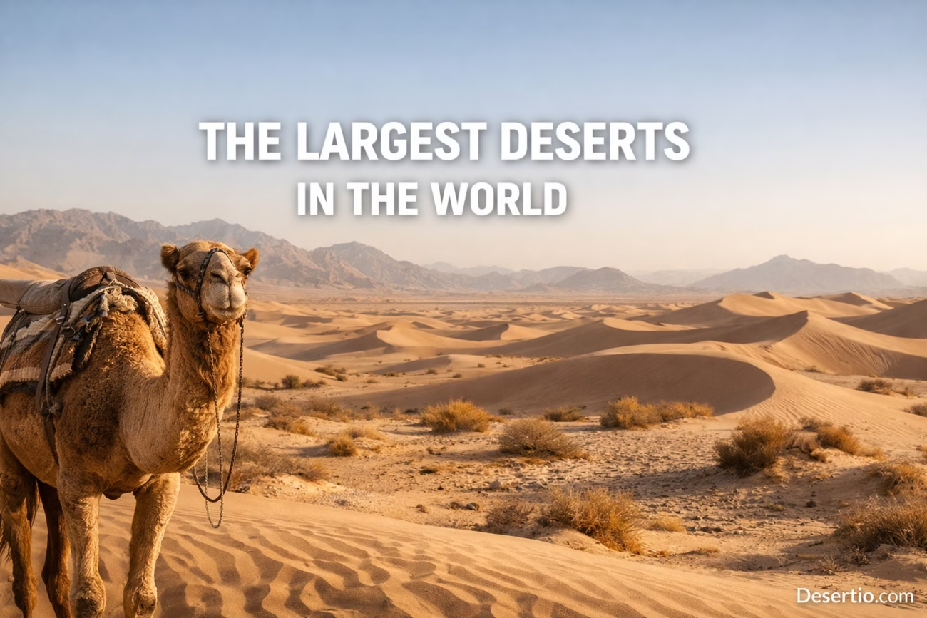
Sahara Desert
The Sahara Desert is the planet’s largest hot desert and a benchmark for “desert scale,” often cited at around 9 million km² (with published estimates varying depending on boundary definitions). It stretches across North Africa in a way that feels continental—because it is. The Sahara is not just dunes; it’s a huge mix of rock plateaus, gravel plains, dry valleys, and salt flats, with sand seas forming a famous (but not exclusive) part of the picture.
One of the Sahara’s defining traits is variety at massive scale. In some regions, dunes roll like an ocean of sand; in others, stone surfaces dominate, and the horizon looks almost architectural. That mix matters for climate, too—different surfaces absorb and release heat differently, shaping local winds and temperature swings.
A useful mental shift: the Sahara is less a single landscape and more a whole library of arid landforms bound into one giant volume.
Arabian Desert
The Arabian Desert, around 2.33 million km² in many references, occupies a broad portion of the Arabian Peninsula. Its reputation is tied to extensive sand and gravel plains, with major dune regions that can feel endless when viewed from above. The desert’s scale is large enough to create its own sense of distance—towns can be far apart, and the sky often feels like the biggest object in the scene.
Within the Arabian Desert, you’ll find a spectrum from compacted gravel surfaces to sweeping dunes. This mix is shaped by wind patterns, sediment supply, and long-term climate rhythms. It’s a place where wind is a patient artist, revisiting the same canvas again and again until the dunes hold a clean, confident curve.
Gobi Desert
The Gobi Desert is one of the world’s largest cold/winter deserts, commonly listed near 1.295 million km². Unlike the sand-only stereotype, much of the Gobi is rocky and gravelly, with broad basins and rugged mountain edges. It sits deep within a continental interior, where seasonal temperature ranges can be wide and moisture is often limited.
The Gobi’s landscapes can feel spacious in a different way than dune deserts. The openness comes from plains and plateaus rather than rolling sand. Add in occasional seasonal snow and you get a desert that feels like two climates sharing one address—dryness stays consistent even as temperatures shift dramatically.
Kalahari Desert
Often listed around 900,000 km², the Kalahari Desert is known for its red sands and a landscape that can include grasses and shrubs as well as classic arid features. “Desert” here doesn’t mean empty; it means water is limited and ecosystems are adapted to that reality. The result is a desert with a softer visual rhythm—less stark, more textured.
The Kalahari is sometimes described as a semi-arid desert region depending on the mapping method used. That’s not a contradiction—it’s a reminder that desert boundaries can be gradual. Picture a fade-out rather than a hard border line, with dry-adapted plants and sandy soils stretching across a broad transition zone.
Patagonian Desert
The Patagonian Desert, commonly cited around 673,000 km², is the largest desert in South America. It’s often described as a cold/winter desert, shaped by winds and the regional pattern of moisture distribution. The scenery leans toward steppe-like plains, gravel surfaces, and broad open spaces rather than towering dunes.
This is a desert where the ground can look brushed rather than piled—wind works with fine sediments and sparse vegetation to create a subtle, layered look. If dune deserts feel like waves, Patagonia often feels like wind-made grain in a vast tabletop landscape.
Great Basin Desert
The Great Basin Desert is commonly listed near 492,000 km². It’s a cold/winter desert defined by basin-and-range geography—valleys separated by mountain ranges—where elevation changes can shape local climate patterns. You’ll often hear it associated with sagebrush ecosystems and salt flats, with aridity as the unifying theme.
Because elevation varies so much, the Great Basin can feel like a collection of connected desert neighborhoods rather than one uniform sweep. Some valleys are notably dry, while higher elevations can collect more snow. The desert identity holds steady through it all: limited moisture, clear skies, and landscapes built from long-term weathering and wind.
Australia’s Big Desert Mosaic
Australia hosts multiple major deserts, and some rankings also group large portions of the interior as a single desert system. When deserts are listed individually, the Great Victoria Desert often appears as the largest single named desert on the continent (about 348,750 km²). Nearby are other substantial deserts—Great Sandy, Simpson, Gibson, and more—each with its own dune patterns and arid textures.
Great Victoria Desert
- Approx. area: 348,750 km²
- Look: parallel dunes, salt lakes, scrub mosaics
- Feel: wide horizons with repeating dune rhythms
Simpson Desert
Not as large as Great Victoria, the Simpson is famous for long linear dunes that look like carefully combed lines across the land. It’s a reminder that shape can be as iconic as size.
Other Notably Large Deserts Worth Knowing
The world has many deserts that may not crack the very top of the area rankings but still define regional geography and climate. If you’re building a mental map of the planet’s arid zones, these names belong in your toolkit.
- Chihuahuan Desert (about 450,000 km²): a high desert with striking biodiversity and mountain basins.
- Karakum Desert (about 350,000 km²): sandy plains and dunes across a broad Central Asian region.
- Taklamakan Desert (about 270,000 km²): one of the world’s great sand seas, ringed by mountain-fed oases.
- Thar Desert (about 264,000 km²): a major subtropical desert with extensive dunes and semi-arid margins.
- Atacama Desert (often listed around 140,000 km²): a coastal desert famed for extreme dryness in some zones.
Landforms That Show Up Again And Again In Giant Deserts
Big deserts aren’t monotonous; they’re full of repeating landform “themes.” Learn these, and you can read desert scenery like a map legend.
- Erg: a sand sea—large dune fields that can stretch for hundreds of kilometers.
- Reg: gravel plains, often firm underfoot and shaped by wind deflation.
- Hamada: rocky plateaus and stony surfaces, common in many major deserts.
- Wadi: a usually dry channel that carries water only during rare runoff events.
- Playa/Salt Flat: flat basins where water evaporates and leaves minerals behind.
When you put all of this together, the “largest deserts” list becomes more than a ranking. It becomes a tour of Earth’s arid engines—polar dryness, subtropical sinking air, continental interiors, rain shadows, and coastal currents—each producing a desert with its own distinct signature.
