| Location | Antarctica (surrounding the South Pole) |
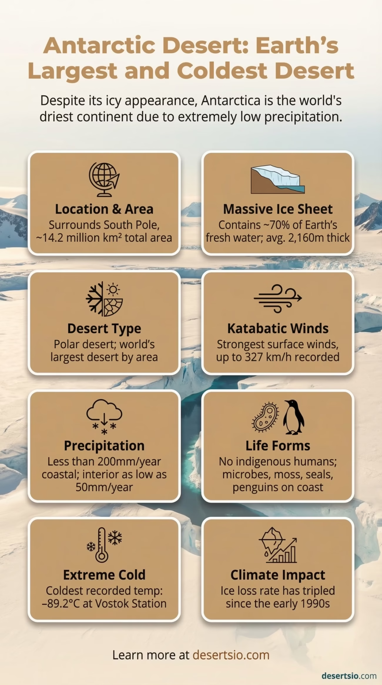
| Total Area | ~14.2 million km² (5.5 million mi²) |
| Desert Type | Polar Desert (Cold Desert) |
| Average Annual Precipitation | Less than 200 mm (coastal); as low as 50 mm (interior) |
| Average Temperature (Summer) | −20°C to −30°C interior; up to −5°C coastal (December–February) |
| Average Temperature (Winter) | −40°C to −70°C interior; −15°C to −25°C coastal |
| Coldest Recorded Temperature | −89.2°C (Vostok Station, 1983); satellite data suggests −98.6°C (2018) |
| Ice Sheet Thickness | Average 2,160 m; maximum ~4,776 m (Denman Glacier) |
| Permanent Human Population | 0 (no indigenous population) |
| Research Stations | ~70 active stations operated by ~30 countries |
| Wind Speed (Record) | 327 km/h (Commonwealth Bay, strongest surface winds on Earth) |
| Ice Volume | ~26.5 million km³ (≈70% of Earth’s fresh water) |
| Comparable Size | Larger than the continental United States and Mexico combined |
The Antarctic Desert is the largest desert on Earth — yet almost nobody calls it a desert. Most people picture sand dunes when they hear the word, but a desert is defined by low precipitation, not by heat. Antarctica receives less than 200 mm of precipitation per year along its coasts, and in some interior regions, that number drops below 50 mm. That makes it drier than the Sahara in many areas. It is, without question, a desert — just one that happens to be buried under a continent-sized slab of ice.
- How Big Is the Antarctic Desert?
- The Antarctic Desert Location and Map View
- Formation: How Did This Desert Come to Be?
- Temperature: A Range That Defies Comprehension
- The McMurdo Dry Valleys: Antarctica’s Most Extreme Patch
- Flora and Fauna: Life Against All Odds
- Human Life: Who Lives Here?
- Antarctica and Climate Change: The Numbers That Matter
- Nearby and Comparable Deserts
- The Katabatic Wind Phenomenon
- Key Facts About the Antarctic Desert at a Glance
- Scientific Value: Why Antarctica Matters Beyond Its Borders
How Big Is the Antarctic Desert?
At approximately 14.2 million km², Antarctica is larger than the United States and Mexico combined. To put that in sharper focus: the Sahara Desert — commonly mistaken as the world’s largest — covers about 9.2 million km². Antarctica is roughly 1.5 times bigger. The continent itself sits on a landmass, but that landmass is almost entirely hidden. Around 98% of Antarctica is covered by the Antarctic Ice Sheet, the single largest mass of ice on the planet.
The ice sheet holds an estimated 26.5 million km³ of ice — approximately 70% of all the fresh water on Earth. If it melted entirely (which is not a near-term scenario, but one studied rigorously by climate scientists), global sea levels would rise by roughly 58 to 60 meters. That number is worth sitting with for a moment.
The Antarctic Desert Location and Map View
Formation: How Did This Desert Come to Be?
Antarctica was not always a frozen wasteland. Around 34 million years ago — during the Eocene-Oligocene transition — the continent began its dramatic cooling. Before that, it was part of the supercontinent Gondwana, connected to South America, Africa, India, and Australia. Fossil records confirm that Antarctica once hosted forests, dinosaurs, and a remarkably temperate climate.
Two processes drove the glaciation. First, the tectonic separation of Antarctica from South America opened the Drake Passage, allowing the Antarctic Circumpolar Current (ACC) to form. This ocean current effectively isolated Antarctica thermally — warm equatorial water could no longer reach the continent. Second, declining atmospheric CO₂ levels during this period removed a key heat-trapping buffer. The combination was decisive. Glaciers expanded, ice sheets formed, and the continent locked into a perpetual freeze that persists today.
The polar desert conditions — extreme cold, minimal precipitation, and ferocious katabatic winds — developed as direct consequences of this geological and atmospheric history.
Temperature: A Range That Defies Comprehension
The day-night temperature difference across most deserts is dramatic. In the Antarctic Desert, the contrast is less about day and night — and more about season and geography. During the polar summer (December to February), coastal regions can reach as high as −5°C. Interior regions, like the East Antarctic Plateau, rarely climb above −20°C even at their warmest.
Winter is another matter entirely.
Interior temperatures regularly fall below −60°C to −70°C during polar night. The coldest temperature ever recorded by a weather station on Earth was −89.2°C at Vostok Station in 1983. More recent satellite thermal data from 2018 recorded surface temperatures approaching −98.6°C in certain East Antarctic valleys — a figure that, if confirmed with ground instruments, would rewrite the record books completely.
Diurnal (day-night) temperature swings do occur in summer, particularly in the Dry Valleys — one of the most studied regions in Antarctica. Temperatures there can shift by 10°C to 20°C between sun-exposed afternoon hours and the chill of midnight sun-angle dips. But “day” and “night” in Antarctica are seasonal rather than daily concepts, especially near the poles.
The McMurdo Dry Valleys: Antarctica’s Most Extreme Patch
The McMurdo Dry Valleys, located in the Transantarctic Mountains, represent one of the most unique environments on Earth. Annual precipitation here falls below 100 mm, and the katabatic winds — cold, dense air that flows downslope off the polar plateau — evaporate any moisture before it can accumulate. The result: exposed rock and soil in a continent otherwise defined by ice. NASA has used the Dry Valleys as an analog environment to study Mars. The resemblance is deliberate — and sobering.
Flora and Fauna: Life Against All Odds
Antarctica is not lifeless — though it comes close. Vegetation is sparse almost beyond measure. The continent supports around 1,150 species of fungi, roughly 700 species of algae, about 100 moss species, and just two flowering plant species: Antarctic hair grass (Deschampsia antarctica) and Antarctic pearlwort (Colobanthus quitensis). Both are restricted to the Antarctic Peninsula, where conditions are marginally less hostile. No trees. No shrubs. No grasses across most of the continent.
Animal life, on the other hand, concentrates along the coasts and in the surrounding Southern Ocean:
- Emperor Penguins (Aptenodytes forsteri) — the only species that breeds on Antarctic sea ice during winter; colonies can number 5,000 to 20,000 individuals
- Weddell Seals — capable of diving to 600 m and holding breath for over 80 minutes
- Leopard Seals — apex predators of the coastal zone
- Antarctic Krill (Euphausia superba) — biomass estimated at 300–500 million metric tons; the foundational species of the Southern Ocean food web
- Snow Petrels and Antarctic Terns — among the few birds breeding deep inland, sometimes nesting 300+ km from the coast
- Tardigrades and nematodes — microscopic organisms found even in Dry Valley soils, capable of surviving near-total desiccation
Tardigrades — sometimes called “water bears” — are arguably the most resilient animals on the planet. They survive Antarctic conditions, radiation, and even the vacuum of space in laboratory tests. Finding them in Antarctic soil samples was not entirely surprising. Still, their presence underlines how life finds a way even in the harshest desert on Earth.
Human Life: Who Lives Here?
Unlike every other desert on Earth, the Antarctic Desert has no indigenous human population — not now, and not historically. Humans simply did not reach Antarctica until 1820, when Russian, British, and American expeditions sighted the continent almost simultaneously. The first confirmed landing came in 1821. For context, by that point, civilizations had existed on every other continent for tens of thousands of years.
Today, Antarctica is governed by the Antarctic Treaty System (signed 1959, entered into force 1961), which designates the continent as a scientific preserve. Around 70 active research stations operate across Antarctica, run by approximately 30 nations. The population fluctuates seasonally — roughly 4,000 to 5,000 people during the austral summer, dropping to around 1,000 to 1,500 during the brutal winter months when resupply becomes nearly impossible.
These are researchers, support staff, and logistics personnel — not settlers. McMurdo Station (USA) is the largest, housing up to 1,258 people in peak summer. Amundsen-Scott South Pole Station sits directly at 90°S, at an elevation of 2,835 m, and remains staffed year-round by a small winter-over crew of around 40 to 50 scientists.
Antarctica and Climate Change: The Numbers That Matter
The Antarctic Desert is at the center of one of the most consequential scientific discussions of the 21st century. Ice loss data from the GRACE and GRACE-FO satellite missions (NASA) shows that Antarctica is losing ice mass at an accelerating rate. Between 1992 and 2017, the continent lost approximately 2.71 trillion metric tons of ice. The rate of loss tripled between the early 1990s and the 2010s.
The West Antarctic Ice Sheet is considered particularly unstable — some glaciologists describe sections of it as experiencing marine ice sheet instability, a feedback mechanism that, once triggered, may be difficult to reverse. The Thwaites Glacier (sometimes called the “Doomsday Glacier”) alone contains enough ice to raise global sea levels by approximately 65 cm, and its retreat is being monitored with intense international concern.
In 2023 and 2024, Antarctic sea ice extent hit record lows — a statistic that alarmed climate scientists globally, as sea ice plays a critical role in reflecting solar radiation back into space (the albedo effect) and regulating deep ocean circulation.
| Time Period | Ice Mass Loss | Rate |
| 1992–2002 | ~44 billion metric tons/year | Baseline rate |
| 2002–2012 | ~112 billion metric tons/year | ~2.5× increase |
| 2012–2017 | ~219 billion metric tons/year | ~5× baseline |
| 2023–2024 | Record low sea ice extent recorded | Ongoing monitoring |
Nearby and Comparable Deserts
The Antarctic Desert does not exist in geographic isolation — the Arctic Desert is its northern counterpart, covering parts of northern Canada, Russia, Greenland, Norway, and Alaska. At roughly 13.9 million km², the Arctic Desert is the second-largest desert on Earth and shares many characteristics with Antarctica: extreme cold, minimal precipitation, and polar desert ecology. However, unlike Antarctica, the Arctic is an ocean surrounded by continents — not a continent surrounded by ocean. That distinction matters enormously for wildlife; polar bears, Arctic foxes, and musk oxen inhabit the Arctic, species with no Antarctic equivalents.
Further north of the Antarctic continent lies the Sub-Antarctic region — islands like South Georgia, the Falkland Islands, and Heard Island. These are not deserts but rather cold maritime environments with dramatically richer biodiversity. South Georgia alone supports millions of nesting seabirds and some of the world’s largest fur seal populations.
In terms of physical comparison, the Antarctic Desert shares structural similarities with the Atacama Desert in South America — both are among the driest places on Earth by precipitation. But their mechanisms are entirely different. The Atacama is hot, rain-shadowed, and coastal. The Antarctic Desert is cold, wind-scoured, and polar. And the Atacama, at roughly 105,000 km², is over 135 times smaller than Antarctica. A very different beast.
The Katabatic Wind Phenomenon
Katabatic comes from the Greek word for “going downhill” — and that is exactly what these winds do. Cold, dense air from the elevated interior of Antarctica flows downslope toward the coast, accelerating as it goes. At Commonwealth Bay on the George V Coast, average annual wind speeds reach 80 km/h, with gusts recorded at 327 km/h — the strongest surface winds ever measured on Earth.
These winds are not just meteorological curiosities. They shape the desert’s ecology, erode exposed rock surfaces, redistribute snow, and make large sections of the coast essentially uninhabitable even for cold-adapted species. They also influence global weather patterns — katabatic outflow from Antarctica drives deep water formation in the Southern Ocean, affecting ocean circulation at a planetary scale.
Key Facts About the Antarctic Desert at a Glance
- World’s largest desert by area (14.2 million km²)
- World’s coldest, driest, and windiest continent simultaneously
- Holds ~70% of Earth’s fresh water as ice
- Only continent with no native human population or indigenous history
- Home to the coldest recorded temperature in Earth’s history (−89.2°C)
- Governed internationally by the Antarctic Treaty — no single country owns it
- Ice loss has tripled in rate since the early 1990s
Scientific Value: Why Antarctica Matters Beyond Its Borders
Ice cores drilled from the Antarctic Ice Sheet are among the most valuable scientific archives on the planet. The EPICA (European Project for Ice Coring in Antarctica) core, drilled at Dome C, captured a continuous climate record stretching back 800,000 years — covering eight complete glacial cycles. Researchers can read past CO₂ concentrations, temperature proxies, volcanic eruptions, and even ancient dust storms directly from these ice cylinders. Nothing else in the natural world offers a comparable archive.
And there is more. Subglacial Lake Vostok — buried beneath approximately 3,750 m of ice — has remained isolated from the atmosphere for an estimated 15 to 25 million years. Microbes discovered in ice above the lake suggest that life may persist in the lake itself, in conditions somewhat analogous to the subsurface oceans theorized to exist on Jupiter’s moon Europa. The astrobiological implications are significant.
The Antarctic Desert, in other words, is not merely the world’s largest desert. It is an active laboratory, a climate archive, a biodiversity refuge, and arguably the most consequential piece of real estate on Earth when it comes to understanding our planet’s future. It is extreme by every measure — and irreplaceable for exactly that reason.
