| Location | Northern Africa |
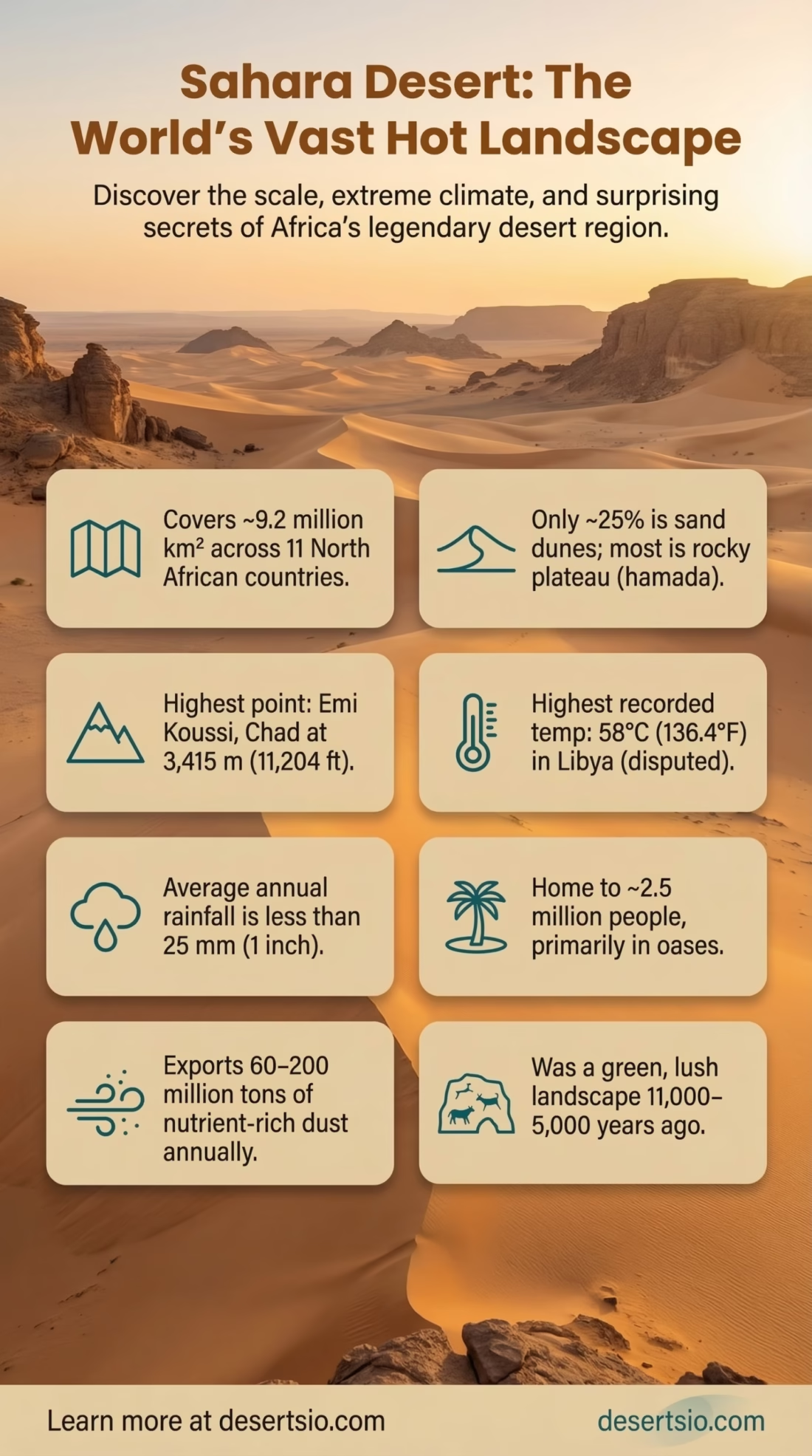
| Total Area | ~9.2 million km² (3.55 million mi²) |
| Countries Covered | Algeria, Chad, Egypt, Libya, Mali, Mauritania, Morocco, Niger, Sudan, Tunisia, Western Sahara (11 territories) |
| Desert Type | Subtropical hot desert (Köppen: BWh) |
| Highest Point | Emi Koussi, Chad — 3,415 m (11,204 ft) |
| Lowest Point | Qattara Depression, Egypt — −133 m (−436 ft) |
| Average Annual Rainfall | Less than 25 mm (1 inch) per year |
| Highest Recorded Temperature | 58°C (136.4°F) — El Azizia, Libya (1922, though disputed) |
| Average Summer Temperature | 38–40°C (100–104°F); peaks can exceed 50°C |
| Average Winter Temperature | 13°C (55°F); frost possible at night in elevated zones |
| Sand Dune Coverage | ~25% of total area (ergs) |
| Rocky Plateau Coverage | ~70% (hamada and reg terrain) |
| Major Water Feature | Nile River (eastern edge) |
| Largest Sand Sea | Issaouane Erg, Algeria (~38,000 km²) |
| Wind System | Harmattan, Sirocco, Khamsin |
| Population (within Sahara) | ~2.5 million people (mostly oasis settlements and nomadic groups) |
| Primary Vegetation | Sparse; acacia, doum palm, ephedra in oases |
| Notable Wildlife | Fennec fox, dromedary camel, Saharan cheetah, deathstalker scorpion, Barbary sheep |
The Sahara Desert is not simply the world’s largest hot desert — it is a landscape that defies easy description. Stretching across 11 countries and covering roughly 9.2 million square kilometers, it accounts for about 31% of Africa’s total land area and forms the dominant core of the desert landscapes of Africa. To put that in perspective, the Sahara is nearly as large as the United States. And yet, for all its vastness, it remains one of the most misunderstood environments on Earth.
- Sahara Desert Location and Map View
- Geography and Terrain: Far More Than Sand
- Climate Mechanics: Why the Sahara Is So Extreme
- The Green Sahara: A Desert That Was Once Alive
- Wildlife and Adaptation: Surviving the Impossible
- People of the Sahara: Ancient Routes and Living Cultures
- Natural Resources and Economic Significance
- The Sahara and Global Climate Systems
- Desertification and the Expanding Sahara
- Scientific Research in the Sahara
- Oases: The Sahara’s Hidden Ecosystems
- The Sahara’s Night Sky and Astronomical Value
- Geological Age and Structural Complexity
Sahara Desert Location and Map View
Geography and Terrain: Far More Than Sand
Most people picture the Sahara as an endless ocean of golden dunes. That image — while dramatic — represents only about 25% of the desert’s actual surface. The rest is a mosaic of terrain types that rarely gets the attention it deserves.
The dominant landscape is hamada — flat, wind-scoured rocky plateaus stripped bare by millennia of erosion. Then comes reg, vast gravel plains packed so tightly that walking on them feels almost surreal. And yes, the ergs — the great sand seas — do exist, rising in some places to dunes over 180 meters tall. The Erg Chebbi in Morocco and the Grand Erg Oriental in Algeria are among the most studied.
Beneath all of this lies something extraordinary: the Nubian Sandstone Aquifer System, one of the largest known fossil water reserves on the planet. It holds an estimated 150,000 cubic kilometers of water, though most of it accumulated during a much wetter climatic period thousands of years ago. Today, nations like Libya and Egypt tap into it for agriculture — drawing water that fell as rain perhaps 40,000 years ago.
Climate Mechanics: Why the Sahara Is So Extreme
The Sahara sits directly beneath the subtropical high-pressure belt — a persistent atmospheric ridge that suppresses rainfall with remarkable efficiency. This system, part of the Hadley Cell circulation, forces descending dry air over the region year-round. The result is a moisture deficit that is almost total in some zones.
Rainfall, when it does occur, is highly localized and unpredictable. Some weather stations in the central Sahara have recorded zero precipitation for years at a time. The Ahaggar highlands in Algeria and the Tibesti Mountains in Chad receive slightly more — sometimes 50–100 mm annually — which supports isolated pockets of vegetation.
Temperature swings are violent. Daily fluctuations between day and night can reach 30°C or more — a phenomenon driven by the near-total absence of humidity, which would otherwise trap heat. Sand absorbs and releases thermal energy with little resistance. In winter, temperatures in elevated areas can drop below freezing overnight, occasionally producing frost.
Key Wind Systems of the Sahara
- Harmattan — A dry, dusty trade wind blowing southwest from the Sahara toward the Gulf of Guinea; carries enormous dust plumes across West Africa between November and March.
- Sirocco — Moves northward from the Sahara toward the Mediterranean coast, bringing heat and fine sand as far as southern Europe.
- Khamsin — A hot, dry wind in Egypt and the eastern Sahara, typically occurring in spring, capable of reducing visibility to near zero within minutes.
The Green Sahara: A Desert That Was Once Alive
Here is a fact that tends to genuinely surprise people: the Sahara was once green. Between approximately 11,000 and 5,000 years ago, during what geologists call the African Humid Period (sometimes referred to as the “Green Sahara”), the region experienced dramatically increased monsoon rainfall. Lakes, rivers, grasslands, and forests covered much of what is now barren rock and sand.
Cave paintings in the Tassili n’Ajjer plateau of Algeria — recognized as a UNESCO World Heritage Site — depict hippos, crocodiles, cattle, and humans swimming. These aren’t abstract symbols. They are precise observations of a landscape that no longer exists in that form.
The transition from humid to arid conditions happened gradually, then rather abruptly. Around 5,500 years ago, a feedback loop — reduced vegetation leading to higher surface albedo (reflectivity), which disrupted monsoon circulation — accelerated desertification significantly. This event may have driven early human populations toward the Nile Valley, contributing to the conditions under which ancient Egyptian civilization emerged. Climate and civilization, it turns out, are tightly wound together.
Wildlife and Adaptation: Surviving the Impossible
Life in the Sahara doesn’t just survive — it adapts in ways that continue to surprise researchers. The desert supports over 500 plant species, 70 mammal species, 90 bird species, and around 100 reptile species, according to ecological surveys of the region.
The fennec fox (Vulpes zerda) is perhaps the most iconic. Its oversized ears — proportionally the largest of any canid — serve as radiators, dissipating body heat with remarkable efficiency. It is also largely nocturnal, avoiding peak daytime temperatures entirely. The fennec can survive without free water, deriving moisture entirely from its food.
Then there is the dromedary camel — not native to the Sahara originally, but so thoroughly adapted to it over millennia that it has become a defining symbol. Contrary to popular belief, a camel’s hump stores fat, not water. This fat reserve can be metabolized into both energy and water. A camel can lose up to 25% of its body weight in water and still function — a threshold that would be fatal for most mammals at far lower levels.
The Saharan silver ant (Cataglyphis bombycina) deserves a special mention. It forages exclusively during the hottest part of the day — when predators retreat — and can tolerate body temperatures of up to 53.6°C. Its silver-coated hairs reflect sunlight and radiate heat simultaneously, making it one of the most thermally sophisticated insects known to science.
People of the Sahara: Ancient Routes and Living Cultures
The Sahara has never been truly empty of people. The Tuareg — a Berber people — have navigated its trade routes for over a thousand years, moving goods like gold, salt, and slaves (historically) across the trans-Saharan caravan network. Today, Tuareg communities remain in Niger, Mali, Algeria, and Libya, numbering somewhere between 1.5 and 2 million people, though estimates vary considerably.
Timbuktu — now in Mali — was once a major intellectual and commercial hub precisely because of its position on Saharan trade routes. At its peak in the 15th and 16th centuries, the city hosted 25,000 students and contained one of the Islamic world’s most significant manuscript collections. Many of those manuscripts, now totaling an estimated 700,000 documents, are still being preserved and digitized through ongoing international efforts.
And the Toubou, an ethnic group centered in Chad, Sudan, and Libya, have developed one of the most remarkable adaptation strategies of any desert-dwelling people — moving with seasonal water sources and maintaining a social structure built entirely around resource mobility. They are not nomads by tradition only; they are nomads by ecological necessity.
Natural Resources and Economic Significance
The Sahara sits on top of significant hydrocarbon reserves. Algeria and Libya together hold some of the largest proven oil and natural gas deposits on the African continent — much of it located beneath desert terrain. Algeria’s Hassi Messaoud oil field, discovered in 1956, remains one of the most productive in Africa.
Beyond fossil fuels, the Sahara’s solar energy potential is staggering. The region receives some of the highest solar irradiation values on Earth — averaging 2,500–3,000 kWh per square meter per year in many zones. This has attracted substantial interest from renewable energy developers. The Desertec concept — a proposal to generate solar and wind power in the Sahara and transmit it to Europe via high-voltage lines — has been discussed since the early 2000s, though large-scale implementation has faced economic and political hurdles. More recently, Morocco’s Noor Ouarzazate Solar Complex, one of the world’s largest concentrated solar power plants, has brought this vision closer to practical reality, with an installed capacity of over 580 MW.
Phosphate deposits — critical for global fertilizer production — are also present in significant quantities in Morocco and Western Sahara, regions that sit at the Sahara’s northwestern edge.
The Sahara and Global Climate Systems
The Sahara’s influence extends far beyond its borders. Every year, the desert exports an estimated 60–200 million metric tons of dust into the atmosphere. This dust — carried by the Harmattan and other winds — plays a genuinely important role in global biogeochemical cycles.
Saharan dust fertilizes the Amazon rainforest. Phosphorus-rich particles from the Bodélé Depression in Chad — described as the most active dust source on Earth — cross the Atlantic and deposit nutrients in South American soils. Without this input, the Amazon’s notoriously nutrient-poor soils would be even more depleted. It’s an unlikely connection: a desert feeding a rainforest, across 5,000 kilometers of open ocean.
The dust also influences hurricane formation in the Atlantic. A heavy Saharan dust season correlates with suppressed Atlantic hurricane activity — the dry, warm dust layer stabilizes the atmosphere and inhibits the convective development that hurricanes need. Meteorologists actively track the Saharan Air Layer (SAL) each hurricane season as a predictive tool.
Desertification and the Expanding Sahara
The Sahara is not static. Studies using satellite data have shown that its boundaries shift seasonally and — over longer timescales — are trending southward into the Sahel, the semi-arid transition zone below. Between 1920 and 2013, the Sahara expanded by approximately 10% in total area, according to research published by scientists at the University of Maryland. Rainfall variability, land degradation, and changing atmospheric patterns all play roles.
The Great Green Wall initiative — an African Union-led project launched in 2007 — aims to restore 100 million hectares of degraded land across the Sahel by 2030, creating a mosaic of restored land stretching 8,000 kilometers from Senegal to Djibouti. As of the mid-2020s, progress has been slower than originally targeted, but several countries — Ethiopia and Senegal in particular — have reported meaningful gains in restored land area.
Sahara by the Numbers: Scale Facts
- The Sahara is larger than Brazil and roughly the size of the contiguous United States
- Its highest dunes (in the Algerian ergs) can reach 180 meters in height
- The Bodélé Depression generates up to 700,000 metric tons of dust per day during peak periods
- The Nile River, which flows along the eastern fringe, is over 6,650 km long — the Sahara shapes its watershed significantly
- Approximately 2.5 million people live within the Sahara’s boundaries, concentrated in oases and river valleys
- Some central Saharan areas receive rainfall as infrequently as once every few years
Scientific Research in the Sahara
Few environments on Earth offer as much scientific value as the Sahara. Its hyperarid conditions preserve organic material, archaeological sites, and geological records with exceptional fidelity. The Ténéré Desert in Niger, for example, has yielded some of the most significant paleontological discoveries of the past few decades — including the remains of Sarcosuchus imperator, a crocodilian species from the Cretaceous period that reached lengths of up to 12 meters.
Meteorite density in the Sahara is notably high. The desert’s flat, pale surfaces make dark meteorite fragments relatively easy to spot, and the dry climate preserves them for thousands of years. Algeria, Libya, and Morocco have all produced significant meteorite finds — including fragments of Martian and lunar origin. The Tissint meteorite, which fell in Morocco in 2011, was only the fifth confirmed Martian meteorite to be witnessed falling by humans.
Researchers also use the Sahara as an analog environment for Mars — testing robotic rovers, life-detection instruments, and remote sensing systems in terrain that shares characteristics with the Martian surface. The Chilean Atacama gets most of the headlines for this, but the Saharan hamada plains offer comparable arid conditions with easier logistical access for many research teams.
Oases: The Sahara’s Hidden Ecosystems
An oasis is not just a watering hole. It is a fully functioning microecosystem — one that can support complex agricultural systems, permanent settlements, and remarkable biodiversity within the broader desert matrix.
The Siwa Oasis in Egypt, located in the Libyan Desert, sits about 50 meters below sea level and is fed by over 200 natural springs. It has been inhabited continuously for at least 10,000 years and is home to roughly 30,000 people today. The oasis produces dates and olives in significant quantities — Siwa olive oil has a distinct flavor profile shaped by the mineral-rich groundwater and intense solar exposure. And yes, Alexander the Great visited it in 331 BCE to consult the Oracle of Amun. Some places carry weight.
The Dakhla Oasis and Kharga Oasis in Egypt’s Western Desert form part of a chain that once served as a critical waypoint for ancient trade and migration routes. Subsurface water from the Nubian Aquifer feeds these systems — making them, in a very real sense, ancient climate deposits made visible at the surface.
The Sahara’s Night Sky and Astronomical Value
This one doesn’t get mentioned nearly enough. The central Sahara — far from any significant light pollution source — offers some of the darkest skies on Earth. Atmospheric transparency in hyperarid zones like the Algerian and Libyan Sahara is exceptional, with low humidity minimizing the atmospheric scattering that blurs stars even in remote locations elsewhere.
Several astronomical observatories are positioned along the Sahara’s northern fringe — Morocco’s Oukaimeden Observatory at 2,700 meters altitude is one example — and astrophotographers from around the world specifically travel to Saharan locations for the quality of night sky access. On a clear night in the open erg, the Milky Way is not a subtle feature. It is overwhelming.
Geological Age and Structural Complexity
The Sahara’s geology spans billions of years. The Ahaggar (Hoggar) Mountains in central Algeria contain some of the oldest exposed rock on Earth — Precambrian crystalline basement rock dating back over 2 billion years. These ancient formations rise dramatically from the surrounding plains, creating a landscape that feels geologically raw.
The Richat Structure in Mauritania — often called the “Eye of the Sahara” — is a deeply eroded geological dome roughly 50 kilometers in diameter. Visible from orbit, it was initially thought to be a meteorite impact crater. Current consensus holds that it is a symmetrical anticline — a fold in rock layers — eroded over millions of years to reveal concentric rings of different rock types. Its near-perfect circular geometry remains one of the most visually striking geological features anywhere on the African continent.
Volcanic activity shaped parts of the Sahara, too. The Tibesti Mountains in Chad are dominated by shield volcanoes — Emi Koussi being the largest, topping out at 3,415 meters. Some volcanic features in the region show evidence of activity within the last few thousand years, making the Sahara’s geology active rather than simply ancient.
