| Location | Southwestern United States & Northern Mexico |
| Countries | United States (Texas, New Mexico, Arizona), Mexico (Chihuahua, Coahuila, Durango, Zacatecas, Sonora) |
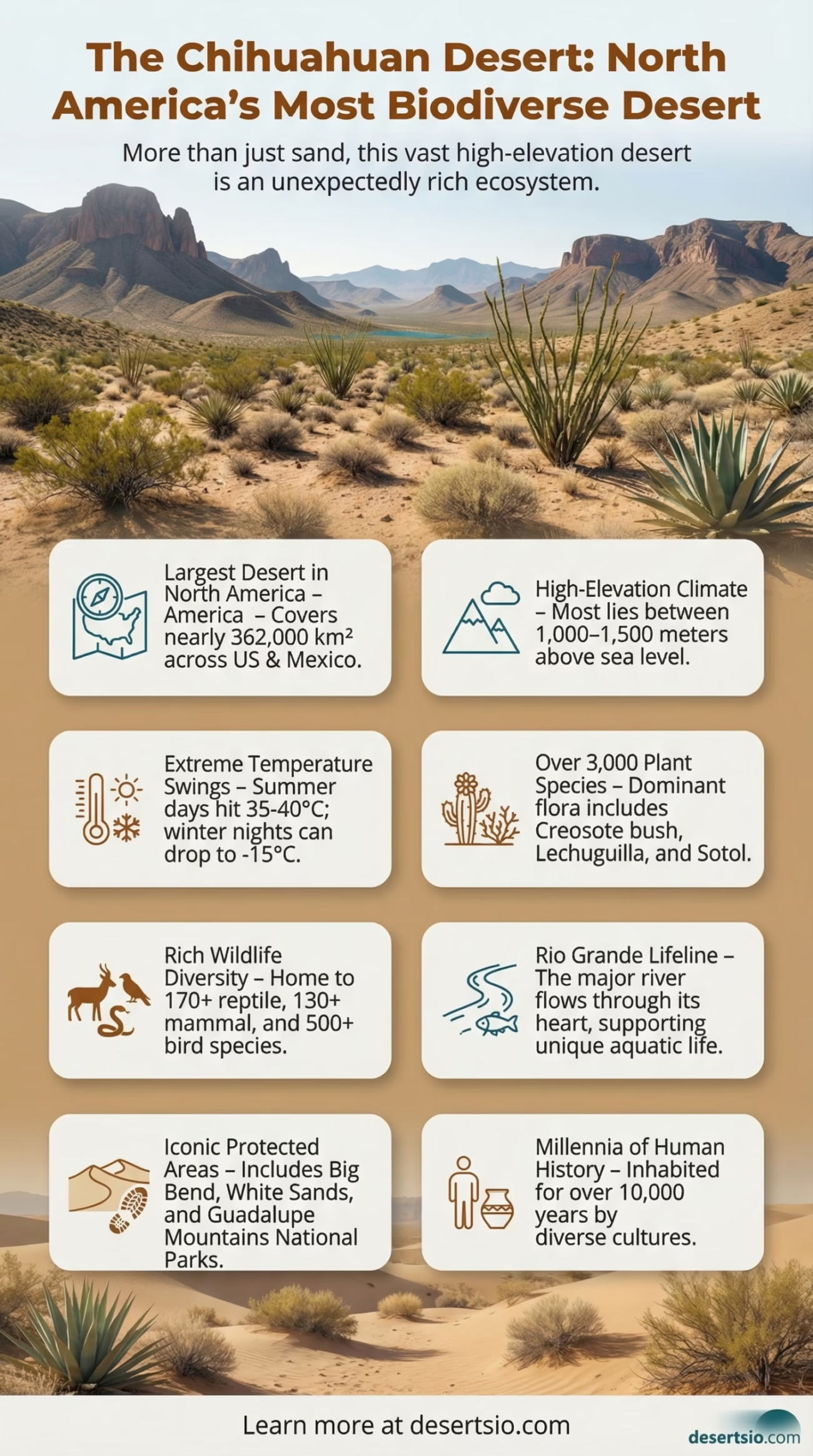
| Total Area | ~362,000 km² (139,769 mi²) |
| Desert Type | Hot Desert / Semi-arid Shrubland |
| Elevation Range | 1,000 – 1,500 m (3,300 – 4,900 ft) above sea level |
| Annual Rainfall | 150 – 400 mm (6 – 16 inches) — mostly summer monsoons |
| Average Summer Daytime Temp | 35–40°C (95–104°F) |
| Average Winter Nighttime Temp | -10 to -15°C (14 to 5°F) |
| Dominant Vegetation | Creosote bush, lechuguilla, sotol, yucca |
| Key Protected Areas | Big Bend National Park, Guadalupe Mountains NP, White Sands NM, Carlsbad Caverns NP |
| Biodiversity | Over 3,000 plant species, 170+ reptile species, 130+ mammal species |
| Major Rivers | Rio Grande / Río Bravo del Norte |
| Nickname | “The Most Biologically Diverse Desert in North America” |
The Chihuahuan Desert doesn’t look like what most people imagine when they think “desert.” There are no endless sand dunes, no camel caravans. Instead, you get towering agave spikes, rolling shrubland, jagged mountain ranges cutting through the basin floor, and a biological richness that genuinely surprises first-time researchers. It is the largest desert in North America — and arguably the most ecologically complex one on the continent.
- Chihuahuan Desert Location and Map View
- Formation: How Did This Desert Come to Be?
- Temperature: Extremes That Catch People Off Guard
- Temperature at a Glance
- Flora: A Desert That Blooms
- Fauna: Surprisingly Dense Wildlife
- Human Life: Who Lives Here?
- Protected Areas and Conservation
- Neighboring Deserts: The Broader Context
- Why the Chihuahuan Desert Matters Right Now
- Chihuahuan Desert: Key Ecological Facts
Stretching across roughly 362,000 square kilometers, the Chihuahuan Desert covers more land than Germany and Poland combined. To put that in sharper perspective: it is approximately 1.4 times the size of the United Kingdom. Most of it — about 90% — lies within Mexico, primarily in the state of Chihuahua, with the rest spilling into the U.S. states of Texas, New Mexico, and a sliver of Arizona.
Chihuahuan Desert Location and Map View
Formation: How Did This Desert Come to Be?
The Chihuahuan Desert owes its existence to geography, not just climate. It sits within the Basin and Range Province — a geologically dynamic zone shaped by tectonic stretching over the past 20–30 million years. As the crust pulled apart, it created alternating mountain ranges and flat basins. Those mountain ranges, the Sierra Madre Occidental to the west and the Sierra Madre Oriental to the east, act as massive rain shadows. Moisture-laden winds from both the Pacific and the Gulf of Mexico lose most of their water before they ever reach the interior basin.
The result? A high-elevation desert — most of it sitting between 1,000 and 1,500 meters above sea level — that receives just enough rainfall (mostly from summer monsoons) to support an astonishing range of life, but not quite enough to escape the “desert” classification. The monsoon season, typically July through September, delivers roughly 60–70% of the annual precipitation in intense, short bursts.
Temperature: Extremes That Catch People Off Guard
People assume deserts are always scorching. The Chihuahuan Desert is more complicated than that. Summer daytime temperatures regularly reach 35–40°C (95–104°F), especially in the lower basins. But because of the high elevation, nights cool down dramatically — sometimes dropping below 20°C even in peak summer. That daily swing of 15–20°C is one of the desert’s defining characteristics.
Winter is where it really surprises. Nighttime temperatures in January can fall to -10 to -15°C (5 to 14°F), and light snowfall is not unusual across the higher elevations. Frost occurs on average 100–120 days per year in parts of the desert. This freeze-thaw cycle shapes both the soil chemistry and which species can survive here long-term.
Temperature at a Glance
- Summer daytime peak: 35–40°C (95–104°F)
- Summer nighttime low: 15–20°C (59–68°F) — a 15–20°C daily swing
- Winter daytime average: 10–15°C (50–59°F)
- Winter nighttime low: -10 to -15°C (5–14°F)
- Annual frost days: 100–120 days in highland zones
- Annual precipitation: 150–400 mm, predominantly summer monsoon
Flora: A Desert That Blooms
With over 3,000 plant species, the Chihuahuan Desert holds the title of the most botanically diverse desert in North America — and it earns that title honestly. The dominant shrub is creosote bush (Larrea tridentata), whose waxy leaves and resinous coating help it survive prolonged drought. After rainfall, the desert fills with a sharp, clean scent — that’s the creosote. Locals in northern Mexico call it gobernadora (the governess), because it essentially dominates whatever landscape it occupies.
Other keystone species include:
- Lechuguilla (Agave lechuguilla) — a spiny, rosette-forming agave found almost exclusively in this desert; a true indicator species
- Sotol (Dasylirion wheeleri) — used traditionally to produce a fermented drink also called sotol, still produced in Chihuahua today
- Ocotillo (Fouquieria splendens) — a tall, whip-like shrub with brilliant red flowers that appear almost immediately after rain
- Candelilla (Euphorbia antisyphilitica) — harvested for its wax, which has commercial uses in cosmetics and pharmaceuticals
- Prickly pear and cholla cacti — widespread across lower elevations
The White Sands region — an iconic gypsum dune field within the desert — has its own micro-adapted plant community, including species that have evolved pale coloration to blend with the white substrate. That’s a level of ecological specificity you rarely see.
Fauna: Surprisingly Dense Wildlife
The Chihuahuan Desert supports over 130 mammal species, 170 reptile species, and more than 500 bird species — numbers that rival many tropical ecosystems in sheer diversity. The Rio Grande / Río Bravo corridor acts as a wildlife highway through the center of the desert, and many migratory birds rely on it as a stopover.
Notable fauna includes:
- Black-tailed prairie dog — keystone species whose burrow systems support dozens of other animals
- Pronghorn antelope — the fastest land animal in the Western Hemisphere, capable of sustained speeds of 88 km/h (55 mph)
- Mexican gray wolf (Canis lupus baileyi) — critically endangered; reintroduction programs in New Mexico and Arizona are ongoing as of 2024
- Desert bighorn sheep — found in rocky escarpments, particularly around Big Bend
- Chihuahuan raven — an endemic species whose name literally comes from this desert
- Western diamondback rattlesnake and multiple other pit vipers — highly adapted ambush hunters
- Mule deer — extremely common, especially along riparian corridors
The desert’s fish fauna is equally remarkable. Many isolated springs and streams contain endemic pupfish species — tiny fish evolved in complete isolation over thousands of years. Some populations exist in single springs with no other water source for hundreds of kilometers. Conservation of these species has become increasingly urgent as groundwater levels drop across the basin.
Human Life: Who Lives Here?
The Chihuahuan Desert has been home to humans for at least 10,000–13,000 years. Archaeological evidence from sites in the Trans-Pecos region of Texas and the Casas Grandes zone in Chihuahua shows continuous human occupation across millennia.
Today, the desert contains several significant population centers. Chihuahua City — the capital of the state of Chihuahua — has a metropolitan population of roughly 1.5 million people. El Paso (Texas) and Ciudad Juárez together form one of the largest binational urban areas on the continent, with a combined population exceeding 2.7 million.
Indigenous communities maintain a living presence in the region. The Rarámuri (also known as Tarahumara) people inhabit the Sierra Madre foothills on the western edge of the Chihuahuan Desert. Known for their extraordinary long-distance running endurance — a cultural and practical tradition rooted in hunting and communication across rugged terrain — the Rarámuri continue to maintain traditional land use practices, including small-scale agriculture in highland barrancas (canyons). Their presence in this landscape predates Spanish colonization by centuries.
Mennonite farming communities, established in the Chihuahua basin during the early 20th century, also form a distinctive cultural layer — and they’re responsible for a significant portion of the region’s apple and cheese production. And ranching (ganadería) remains deeply embedded in the economy on both sides of the border.
Protected Areas and Conservation
The Chihuahuan Desert contains some of the most significant protected landscapes in North America. Big Bend National Park alone covers 3,242 km² — larger than the state of Rhode Island — and protects one of the most remote and geologically diverse sections of the entire desert. The park recorded over 581,000 visitors in 2023, a number that reflects growing interest in desert ecosystems globally.
White Sands National Park (designated a full national park in 2019) protects the world’s largest gypsum dune field — 710 km² of brilliant white sand, a geological anomaly formed from gypsum dissolved from the surrounding mountains and deposited by evaporating Lake Otero roughly 10,000–12,000 years ago.
On the Mexican side, the Reserva de la Biósfera Janos in Chihuahua protects one of the last remaining intact grassland-desert transition zones in North America — and one of the last places where black-tailed prairie dog colonies still function at a landscape scale.
Groundwater depletion remains the desert’s most pressing ecological challenge. The Chihuahuan Desert Research Institute (CDRI), based in Alpine, Texas, has been tracking aquifer levels in the region for decades. Data from the Edwards-Trinity and Pecos Valley aquifers shows measurable decline — a trend linked to agricultural irrigation, urban growth, and increasingly erratic monsoon patterns consistent with regional climate shifts.
Neighboring Deserts: The Broader Context
The Chihuahuan Desert doesn’t exist in isolation. It belongs to a cluster of North American deserts that share overlapping geography and ecology.
| Desert | Area | Type | Key Difference from Chihuahuan |
| Sonoran Desert | ~310,000 km² | Hot desert | Lower elevation, iconic saguaro cactus, hotter overall, two rainy seasons |
| Mojave Desert | ~124,000 km² | Hot/cold transitional | Much smaller, Joshua tree dominant, extreme summer heat in low valleys |
| Great Basin Desert | ~492,000 km² | Cold desert | Higher elevation, sagebrush dominant, primarily cold-driven aridity |
Of these, the Sonoran Desert is the Chihuahuan’s closest geographic and ecological neighbor — the two share a transition zone in southern Arizona and Sonora. But they are distinct ecosystems. The Sonoran is warmer, lower, and receives both winter and summer rainfall (a bimodal precipitation pattern), which allows the giant saguaro cactus (Carnegiea gigantea) to thrive — a species you will never find in the Chihuahuan. The Chihuahuan, by contrast, receives almost all its rain in summer and sits significantly higher, which shapes its flora and fauna in fundamentally different ways.
Why the Chihuahuan Desert Matters Right Now
Desert ecosystems are frequently undervalued — seen as empty, barren, marginal. The Chihuahuan Desert challenges that view directly. It stores significant amounts of carbon in its soils and woody shrubs. It filters and recharges regional aquifers. It anchors the livelihoods of millions of people across two countries. And it contains biodiversity — endemic species found nowhere else on Earth — that science has barely begun to catalog.
Climate projections for the U.S. Southwest and northern Mexico consistently point toward hotter, drier conditions through the mid-21st century. The Chihuahuan Desert will absorb much of that pressure. Some models suggest the desert’s boundaries could expand northward and upslope as temperature thresholds shift — a process already documented in parts of New Mexico and Texas, where creosote bush is colonizing former grasslands at a measurable rate.
This is not a static landscape. It never was. The Chihuahuan Desert has been contracting and expanding for millions of years in response to global climate cycles. What makes the current moment different is the speed of change — and the human systems now built inside and around it that must adapt alongside the ecosystem itself.
Chihuahuan Desert: Key Ecological Facts
- Largest desert in North America by area (~362,000 km²)
- Most botanically diverse North American desert — 3,000+ plant species
- Lechuguilla agave is found almost nowhere else on Earth
- Home to 170+ reptile species — one of the highest concentrations globally
- The Rio Grande runs through its heart for over 3,000 km
- White Sands — the world’s largest gypsum dune field — lies within its boundaries
- Over 40 endemic fish species exist in isolated desert springs
