| Location | Northern Kenya, East Africa |
| Area | Approximately 100,000 km² (38,600 sq mi) |
| Coordinates | 3°N 37°E |
| Elevation | 400–500 m above sea level |
| Desert Type | Hot semi-arid / salt desert |
| Annual Rainfall | Below 25 mm per year |
| Daytime Temperature | Up to 50°C (122°F) |
| Nighttime Temperature | As low as 10°C (50°F) |
| Major Ethnic Groups | Gabbra, Rendille, Borana, Turkana |
| Nearby Lakes | Lake Turkana (west), Lake Stefanie (north) |
| Primary Surface | Salt flats, volcanic rock, lava fields |
| Nearest Town | Marsabit, North Horr |
The Chalbi Desert is one of Africa’s least-visited and most geologically dramatic landscapes — a vast salt flat basin carved out by ancient lake beds, volcanic activity, and relentless heat in northern Kenya. It sits in the shadow of Mount Marsabit, bordered by lava fields and semi-arid scrubland, and remains largely unknown outside of geography and ecology circles. That obscurity is, frankly, part of what makes it remarkable.
- Chalbi Desert: Where It Is, Climate, Map, Salt Pans & Local Ecology
- How Big Is the Chalbi Desert?
- Formation: Ancient Lakes and Volcanic Forces
- Temperature: Extremes by Day and Night
- Flora and Fauna: Life in the Margins
- Human Life: The People of the Chalbi
- Geological and Scientific Significance
- Nearby Deserts and Regional Context
- The Chalbi in the Context of Desertification
- What Makes the Chalbi Genuinely Different
Chalbi Desert: Where It Is, Climate, Map, Salt Pans & Local Ecology
How Big Is the Chalbi Desert?
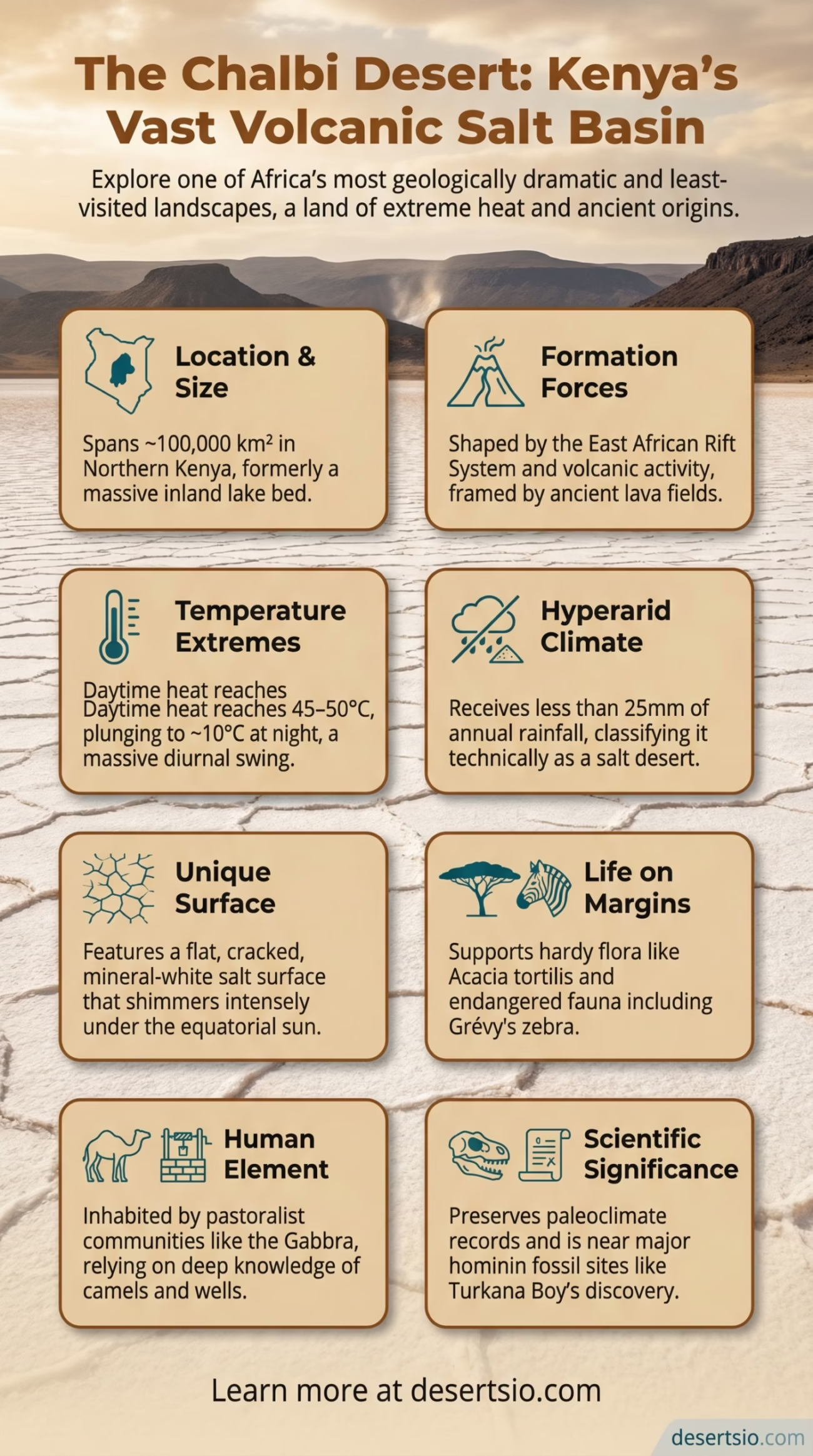
The Chalbi Desert spans roughly 100,000 square kilometers — comparable in size to the entire country of Iceland, or about the same landmass as the U.S. state of Kentucky. It is not the largest desert on the continent by any stretch, but within East Africa, it stands as the only true desert found in Kenya. The basin itself is surprisingly flat, a remnant of what was once a massive inland lake during the African Humid Period (approximately 11,000 to 5,000 years ago). What is left behind is a cracked, pale-white salt surface that shimmers under the equatorial sun.
Formation: Ancient Lakes and Volcanic Forces
The Chalbi’s origin is tied directly to the East African Rift System — one of the most geologically active zones on the planet. As tectonic plates slowly pulled apart over millions of years, the land between them subsided, creating a series of low-lying basins. During wetter climatic periods, these basins filled with water, forming large freshwater or brackish lakes. The Chalbi was, in all likelihood, once connected to or an extension of paleo-Lake Turkana, which itself was dramatically larger thousands of years ago.
As the climate shifted — becoming increasingly arid through the Holocene — the lake evaporated. What remained were thick salt and mineral deposits, the same deposits that give the desert floor its characteristic bleached-white appearance. Volcanic formations surround the basin on multiple sides. The Huri Hills and the Marsabit volcanic massif frame the landscape, and ancient lava flows have created rough, dark terrain that contrasts sharply with the pale desert floor. And that geological contrast — black basalt against white salt — is genuinely striking.
Temperature: Extremes by Day and Night
Heat here is not a background condition. It is the central fact of the Chalbi. Daytime temperatures regularly reach 45–50°C (113–122°F) during the hottest months, primarily between January and March. The salt flats amplify radiant heat — they reflect and re-radiate solar energy at ground level, making the perceived temperature even higher than instruments record.
Nighttime, however, tells a different story. Temperatures can plunge to around 10°C (50°F), a swing of 35–40°C within a single day. This thermal oscillation is typical of arid environments with minimal moisture and vegetation to trap heat — but even among East African deserts, the Chalbi’s diurnal range is considered extreme. Rainfall is almost negligible: less than 25 mm per year on average, making it technically hyperarid by standard classification.
Flora and Fauna: Life in the Margins
Survival here takes specific adaptations. Vegetation is sparse and largely confined to the desert’s edges, where occasional seasonal drainage channels allow moisture to accumulate. The plant species that persist include:
- Acacia tortilis (umbrella thorn acacia) — drought-resistant and deep-rooted
- Salvadora persica (toothbrush tree) — salt-tolerant, common around the salt flat margins
- Commiphora species — shrubby, resinous plants adapted to volcanic soils
- Ephemeral grasses that appear briefly after rare rain events
Wildlife, as expected, is adapted to extremes. The Chalbi and its surrounding ecosystems support:
- Grévy’s zebra (Equus grevyi) — one of the world’s most endangered equid species, found in northern Kenya
- Beisa oryx — supremely well-adapted to heat and water scarcity
- Gerenuk — a long-necked antelope capable of browsing standing upright on hind legs
- Caracal and striped hyena — predators that operate primarily at dawn and dusk
- Numerous migratory bird species, particularly around the Lake Turkana corridor
The Chalbi sits within the broader Lake Turkana ecosystem, a UNESCO World Heritage Site, which acts as a critical migration corridor for birds traveling between the African interior and the Horn of Africa. Over 350 bird species have been recorded in the greater Turkana basin area.
Human Life: The People of the Chalbi
The desert has never been empty. Several pastoralist communities have inhabited the Chalbi and its edges for centuries, developing intricate knowledge systems around water sources, seasonal grazing, and survival in one of East Africa’s harshest environments.
Gabbra — A Cushitic-speaking camel-herding people who are arguably the most iconic community associated with the Chalbi. The Gabbra have developed a deep migratory tradition around camel herds, moving across the desert and into the Huri Hills depending on the season. Their settlements — called olla (temporary encampments) — are structured around communal water management and oral knowledge of the landscape.
Rendille — Another camel-keeping pastoral community, linguistically related to Somali. They inhabit the semi-arid areas south and east of the Chalbi basin, intersecting with the desert during dry season movements.
Borana — Oromo-speaking cattle and camel herders whose territory covers a wide arc across northern Kenya and southern Ethiopia. They are also associated with the olla system and manage livestock in relation to seasonal pasture availability.
Turkana — Primarily concentrated along the Lake Turkana shoreline to the west, the Turkana have historically moved into the Chalbi fringes during wetter periods.
The total population living in and around the Chalbi Desert is estimated at fewer than 150,000 people — a remarkably low density given the region’s geographic scale. North Horr, sitting at the heart of the desert, is the primary settlement and serves as a regional administrative center for Marsabit County. It has a population of only a few thousand.
Climate change is placing increasing pressure on these communities. Rainfall unpredictability, longer drought cycles, and competition over diminishing water sources — particularly around the few permanent wells (called tulas or birkas) — are intensifying resource stress. This is not a distant scenario; it is already an observable pattern in northern Kenya.
Geological and Scientific Significance
The Chalbi is not just a geographic curiosity. It is a scientifically significant landscape that has attracted paleontologists, geologists, and climate researchers for decades. The region around Lake Turkana — the Chalbi’s closest major geographic neighbor — has yielded some of the most important hominin fossils ever discovered. Turkana Boy (Homo ergaster, KNM-WT 15000), found in 1984 at Nariokotome near the lake’s western shore, remains one of the most complete early human skeletons in the fossil record.
The Chalbi basin itself preserves sedimentary records of ancient lake levels and climate shifts that researchers use to model past African climate cycles. The salt deposits — trona, halite, and sodium carbonate — indicate repeated cycles of flooding and desiccation. These records are invaluable for understanding how the region’s climate has changed and, increasingly, how it might behave in the future.
Nearby Deserts and Regional Context
The Chalbi does not exist in isolation. It is part of a broader arid corridor that extends across the Horn of Africa and northeast Africa:
- Kaisut Desert — Located immediately south of the Chalbi in the Marsabit region, the Kaisut is a sandy semi-desert covering parts of Marsabit County. It is less severe than the Chalbi but shares similar fauna and pastoralist communities.
- Ogaden Desert (Ethiopia/Somalia) — Northeast of the Chalbi, the Ogaden is a vast lowland plateau characterized by semi-arid conditions and Somali-region pastoralism. Climatically linked to the same Indian Ocean monsoon system that barely reaches northern Kenya.
- Danakil Depression (Ethiopia/Eritrea) — Among the most extreme environments on Earth, the Danakil shares the Chalbi’s volcanic geology and salt flat characteristics. At 125 meters below sea level, it records some of the hottest temperatures ever measured on the planet — regularly exceeding 50°C year-round. A useful comparison: while the Chalbi is brutal in summer, the Danakil is relentless year-round.
- Chalbi vs. Namib Desert — Both are defined by their salt flat zones and ancient geological origins, but the Namib (southwestern Africa) is a coastal fog desert, shaped by the cold Benguela Current. The Chalbi is a continental interior basin shaped by tectonic subsidence. Two very different processes producing visually similar landscapes.
| Desert | Location | Key Feature | Annual Rainfall |
| Chalbi Desert | Northern Kenya | Salt flat basin, volcanic geology | <25 mm |
| Kaisut Desert | South of Chalbi, Kenya | Sandy semi-desert | ~100–200 mm |
| Danakil Depression | Ethiopia/Eritrea | Lowest point in Africa, active volcanoes | <25 mm |
| Ogaden Desert | Eastern Ethiopia | Plateau semi-arid lowlands | ~150–300 mm |
The Chalbi in the Context of Desertification
Northern Kenya is identified by the UN Environment Programme (UNEP) as a high-risk zone for accelerating desertification. The Chalbi’s semi-arid edges — where pastoralist communities graze — are particularly vulnerable. Overgrazing, combined with irregular rainfall and rising temperatures, is causing vegetative cover to retreat and soil to degrade. This process effectively expands the desert’s functional footprint, even if its technical geographic boundary remains stable.
Kenya’s national climate projections suggest that average temperatures in the arid north could increase by 1.5–3°C by 2050 under moderate emissions scenarios. For a region where water availability is already critical, even a 1°C shift in average temperature meaningfully increases evaporation rates and reduces the reliability of seasonal rains — the short rains (October–November) and long rains (March–May) that pastoralists depend on for pasture regeneration.
Recent drought cycles — particularly the severe 2021–2023 multi-year drought across the Horn of Africa, described by the UN as the worst in 40 years — hit communities around the Chalbi with exceptional intensity. Livestock losses in Marsabit County exceeded 70% in some sub-locations, according to Kenya’s National Drought Management Authority (NDMA) reports from 2022. These are not abstract statistics. They represent the practical limits of survival in an already marginal environment.
What Makes the Chalbi Genuinely Different
Most people, when they think of African deserts, think of the Sahara. The Chalbi operates on an entirely different scale and logic. It is not defined by endless dunes — there are almost none. Instead, it is a flat, cracked, mineral-white basin ringed by volcanic hills and ancient lava flows, with a sky that seems larger than anywhere else in East Africa. The mirage effect here is particularly intense; on calm days, the salt surface produces near-perfect horizontal reflections.
The desert also has a hydrological quirk worth noting. During exceptionally rare heavy rainfall events, water briefly floods the Chalbi basin — sometimes attracting flamingos and other wading birds that have no business being in a desert. These short-lived seasonal floods, called flash lake events by local researchers, turn the salt flat into a shallow reflective lake for days or sometimes weeks before the water evaporates back into the crust. Strange. Temporary. Unforgettable, apparently, for those who witness it.
The Chalbi Desert is, in the end, a place defined by contradiction — ancient and actively changing, isolated yet inhabited, inhospitable yet ecologically intricate. Understanding it means understanding a much larger story about how landscapes form, how life adapts, and how communities endure.
