| Location | Northwestern Nevada, United States |
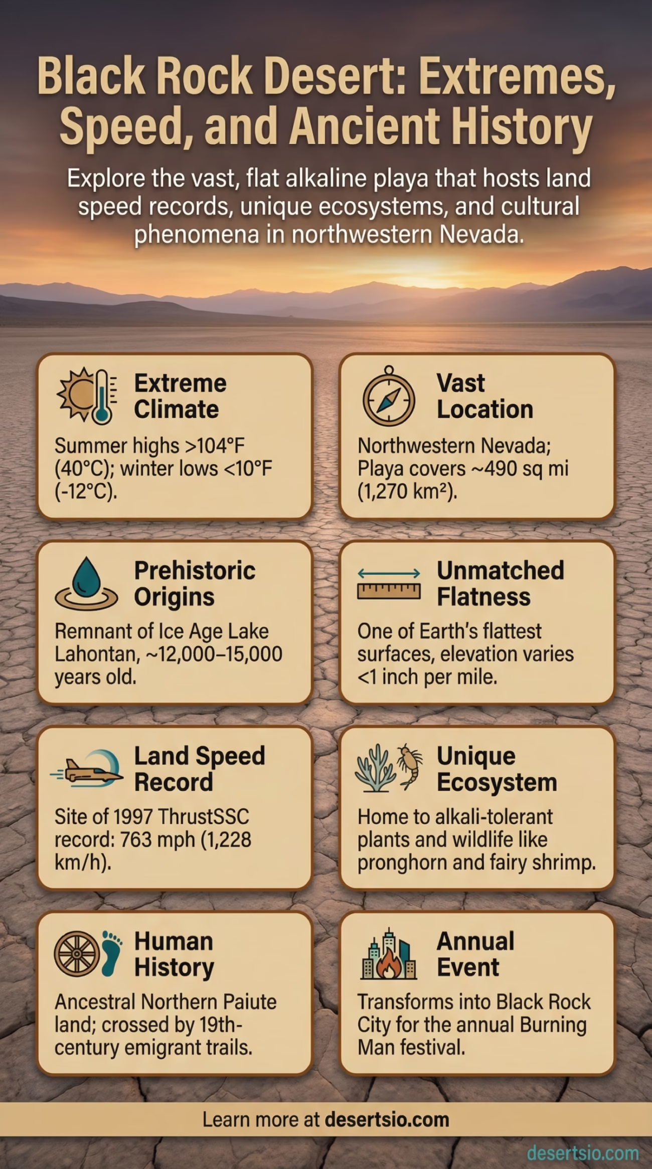
| Total Area | ~1,000 sq mi (2,590 km²) — playa alone covers ~490 sq mi (1,270 km²) |
| Elevation | ~3,848 ft (1,173 m) above sea level |
| Desert Type | Cold desert / Basin and Range playa |
| Annual Precipitation | ~7 inches (178 mm) per year |
| Average Summer High | ~95–104°F (35–40°C) during the day |
| Average Night Temp (Summer) | ~45–55°F (7–13°C) — a 40–50°F daily swing is common |
| Average Winter Low | Can drop below 10°F (-12°C) |
| Playa Surface | Alkaline lakebed — silt, clay, and evaporite minerals |
| Nearest Major City | Reno, NV (~100 miles / 160 km south) |
| Land Management | Bureau of Land Management (BLM) |
| Notable Record | Land speed record site — Andy Green set 763 mph (1,228 km/h) record nearby in 1997 |
| Annual Event | Burning Man Festival (Black Rock City, pop. ~80,000 during event) |
The Black Rock Desert sits in the middle of northwestern Nevada like a blank page — flat, cracked, and almost impossibly wide. At first glance, it looks like nothing at all. And yet this sun-scorched alkaline playa holds land speed world records, hosts one of the most talked-about cultural events on the planet, and has a geological history stretching back roughly 12,000 years. It is one of the most extreme environments in North America, and arguably one of the most misunderstood.
- Black Rock Desert: Location, Playa Geology, Map, Weather & Key Facts
- How the Black Rock Desert Formed
- How Big Is It, Really?
- Temperature: A Desert of Extremes
- Flora and Fauna: Life on the Edge
- Human Life and History in the Black Rock
- Speed, Science, and the Playa’s Unique Physics
- Nearby Deserts and Regional Context
- Conservation Challenges and Current Issues
- Desert Glossary: Black Rock Key Terms
- What Makes Black Rock Genuinely Unusual
Black Rock Desert: Location, Playa Geology, Map, Weather & Key Facts
How the Black Rock Desert Formed
Around 12,000–15,000 years ago, during the last Ice Age, this entire basin was submerged beneath Lake Lahontan — a massive prehistoric lake that covered much of present-day Nevada and California. At its peak, Lake Lahontan stretched over 8,500 square miles and reached depths of nearly 900 feet (274 m) in some areas. That’s larger than Lake Erie today.
As the climate warmed and dried at the end of the Pleistocene epoch, the lake gradually evaporated. What it left behind was the Black Rock playa — a perfectly leveled lakebed of compressed silt, clay, and alkaline mineral deposits. The flatness is not accidental. Water, over millennia, is the world’s most patient engineer.
The surrounding region sits within the Basin and Range Province, a geologically active zone defined by a series of north-south fault blocks. The Black Rock range to the east and the Calico Mountains to the west frame the playa like walls, trapping heat and dust in summer.
How Big Is It, Really?
The playa alone covers approximately 490 square miles (1,270 km²). The broader Black Rock Desert–High Rock Canyon Emigrant Trails National Conservation Area — managed by the Bureau of Land Management — spans around 1,200 square miles (3,100 km²). To put that in perspective, the entire playa is roughly three times the size of Washington, D.C. It is the largest flat surface in the United States and one of the flattest places on Earth.
Elevation variance across the main playa? Less than one inch per mile. That kind of precision is what makes it a natural laboratory for speed testing and astronomical observation alike.
Temperature: A Desert of Extremes
The Black Rock Desert is not just hot — it is volatile in temperature. In summer, midday surface temperatures on the playa can exceed 140°F (60°C) due to direct solar radiation on the pale alkaline surface. Air temperatures regularly hit 100–104°F (38–40°C). But once the sun sets, things change fast.
Nighttime temperatures in summer drop to 45–55°F (7–13°C), creating a daily swing of 40–50°F (22–28°C). That kind of temperature range in a single 24-hour period puts serious stress on anything — and anyone — out there. Winter nights can plunge to 10°F (-12°C) or below.
Wind compounds everything. The playa channels strong gusts — sometimes exceeding 60 mph (97 km/h) — that carry fine alkaline dust. This dust, locally called “playa dust,” is caustic and extremely fine (particle sizes as small as 2–10 microns), capable of penetrating equipment, lungs, and eyes with very little warning.
Flora and Fauna: Life on the Edge
The playa itself is nearly biologically sterile — nothing grows on the flat alkaline surface. But the surrounding desert is a different story. The Black Rock Desert sits within the Great Basin Desert ecosystem, and the transition zones around the playa host a surprisingly varied set of species.
Plant life in the region includes:
- Shadscale saltbush (Atriplex confertifolia) — one of the most alkali-tolerant shrubs in North America
- Basin big sagebrush (Artemisia tridentata) — the signature plant of the Great Basin, covering vast upland areas
- Greasewood (Sarcobatus vermiculatus) — found along the playa margins where moisture accumulates
- Rabbitbrush and bitterbrush species along rocky bajadas
Wildlife found in and around the Black Rock region:
- Pronghorn antelope — North America’s fastest land animal, capable of 55 mph; populations have been documented in the High Rock Canyon area
- Greater sage-grouse — a federally threatened species; critical habitat overlaps with the conservation area
- Burrowing owls, golden eagles, and prairie falcons — all active in the region’s uplands
- Coyotes, black-tailed jackrabbits, and kit foxes — more commonly seen near the playa edges at dawn and dusk
- Migratory waterfowl — when seasonal water collects on the playa after rain events, shorebirds and ducks use it as a temporary stopover
And when the playa floods — which does happen in wet winters — fairy shrimp (Artemia-related species) can appear within days, emerging from dormant cysts baked into the alkaline crust. Life finds a way, even here.
Human Life and History in the Black Rock
The Northern Paiute people — known to themselves as the Numu — have lived in and around the Black Rock region for thousands of years. They were highly adapted to the Great Basin’s difficult environment, practicing a seasonal migration pattern that followed food sources: pine nuts in autumn, waterfowl during spring flooding, roots and seeds in summer.
The 19th century brought a very different kind of traveler. The Applegate-Lassen Trail, a cutoff of the California Emigrant Trail, crossed the Black Rock Desert beginning in 1848. Emigrants heading to California during the Gold Rush era crossed the playa — sometimes at night to avoid heat — hauling wagons across 40+ miles of barren, waterless expanse. Wagon ruts from those crossings are still visible in parts of the High Rock Canyon area today.
Today, the Black Rock Desert has no permanent population on the playa itself. The nearest town is Gerlach, Nevada — a community of fewer than 250 people. But for one week every year in late August and early September, the playa transforms into Black Rock City, temporarily becoming Nevada’s third-largest city during the Burning Man festival (population ~80,000).
Speed, Science, and the Playa’s Unique Physics
The Black Rock playa has attracted land speed record attempts since the early 20th century. Its near-perfect flatness, combined with the hard-baked alkaline surface (compressive strength of ~40 psi when dry), makes it one of only a handful of places on Earth where jet-powered vehicles can safely attempt records.
In October 1997, Andy Green drove the ThrustSSC jet-propelled car across the Black Rock playa at 763.035 mph (1,227.9 km/h) — breaking the sound barrier on land for the first time in history. This remains the official land speed world record to this day. The run covered roughly 10 miles of playa and was verified by the FIA (Fédération Internationale de l’Automobile).
Scientists have also used the playa for atmospheric research, NASA rover testing (due to surface similarities with Mars terrain), and radio telescope calibration. The absence of radio interference, combined with extreme flatness, makes it genuinely useful for scientific work.
Nearby Deserts and Regional Context
The Black Rock Desert sits within the broader Great Basin Desert — the largest desert in the United States, covering approximately 190,000 square miles (492,000 km²) across Nevada, Utah, Oregon, Idaho, and California. Understanding where Black Rock fits within this region helps frame its character.
| Desert / Region | Location | Notable Feature |
| Great Basin Desert | Nevada, Utah, Oregon | Largest cold desert in the U.S.; Black Rock is part of this system |
| Alvord Desert | SE Oregon | Similar alkali playa; also used for land speed attempts; ~12,000 acres |
| Bonneville Salt Flats | NW Utah | Best-known playa in the U.S.; International Speedway; slightly smaller flat area than Black Rock |
| Mojave Desert | Southern California / Nevada | Hot desert; lower elevation; borders Great Basin to the south |
| High Rock Canyon | NW Nevada (adjacent) | Part of the same NCA; dramatic volcanic canyon system immediately north of the playa |
The Alvord Desert in southeastern Oregon deserves a specific mention — it is Black Rock’s closest geographic and geological cousin. Both are remnant playas of Ice Age lakes, both sit at high basin elevations, and both have been used for speed record attempts. Alvord is far less visited and considerably smaller (~7 miles long vs. Black Rock’s ~100-mile playa perimeter), but the two share an almost eerie visual similarity.
Compared to the Bonneville Salt Flats in Utah — which many people assume is the United States’ premier playa — Black Rock is actually larger in total flat area, though Bonneville holds the official FIA speed course designation. Both surfaces are ancient lakebed remnants, both are alkaline, and both face similar threats from groundwater extraction and changing precipitation patterns.
Conservation Challenges and Current Issues
The Black Rock Desert–High Rock Canyon Emigrant Trails National Conservation Area was formally established in 2000, giving it federal protection under BLM management. The designation covers approximately 1.2 million acres total, including wilderness areas, the emigrant trail corridors, and the playa itself.
But protection does not mean immunity from pressure. Several active concerns shape the desert’s future:
- Dust and air quality: The fine alkaline particulates — PM10 and PM2.5 — are monitored by Nevada environmental agencies. Large events and vehicle traffic disturb the crust and increase particulate levels significantly.
- Playa surface degradation: Heavy vehicle use during wet conditions leaves deep ruts that can persist for years. The BLM enforces seasonal closures when surface moisture exceeds safe thresholds.
- Water table and groundwater: Agricultural irrigation in surrounding Humboldt County draws from the same aquifer system that occasionally feeds the playa. Long-term groundwater depletion could affect seasonal flooding patterns.
- Greater sage-grouse habitat: Federal land-use plans for the Great Basin increasingly center on protecting sage-grouse habitat, which overlaps significantly with the Black Rock NCA’s upland zones.
Desert Glossary: Black Rock Key Terms
Playa: A flat-bottomed dry lakebed found in arid basins; the surface consists of fine sediments left by evaporated water. Playas are among the flattest natural surfaces on Earth.
Evaporite Minerals: Salts and minerals (such as halite, trona, and borax) that crystallize from water as it evaporates; responsible for the white and pale-gray crust visible on the Black Rock playa surface.
Basin and Range Province: A geologic region of the western United States characterized by alternating valleys (basins) and mountain ranges formed by crustal extension and fault movement.
Numu: The self-designation of the Northern Paiute people, meaning “the people.” Indigenous inhabitants of the Great Basin region for thousands of years before European contact.
PM2.5 / PM10: Particulate matter classifications by size (in microns); smaller particles penetrate deeper into the lungs. Alkaline playa dust is classified in these categories and is a monitored air quality concern.
What Makes Black Rock Genuinely Unusual
Most deserts are defined by what they lack — water, shade, life. Black Rock has all of those absences. But it also has something harder to quantify: scale that the mind resists. Standing at the center of the playa, the horizon is unbroken in every direction. The curvature of the Earth becomes perceptible. Sound behaves strangely. Heat shimmer turns distant mountains into floating islands.
And it’s not static. After winter rains, shallow water sheets across the playa — sometimes covering hundreds of square miles to a depth of just a few inches — creating the kind of mirror-flat reflections that photographers and filmmakers travel thousands of miles to capture. Within weeks, it’s gone. The playa cracks again. The dust returns.
The Black Rock Desert is, in one sense, one of the emptiest places in the continental United States. In another sense, it’s one of the most layered — geologically, historically, and culturally. And that tension, between absence and density, is what makes it worth understanding properly.
