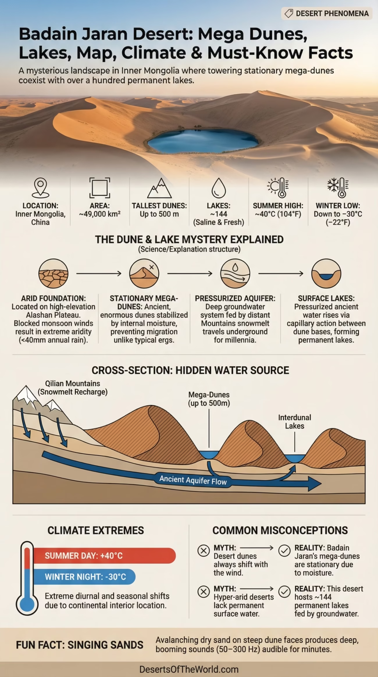
| Location | Inner Mongolia, China (Alashan Plateau) |
| Area | ~49,000 km² (approximately 18,900 sq mi) |
| Type | Sand desert (erg) with mega-dunes |
| Tallest Dunes | Up to 500 m (1,640 ft) — among the tallest in the world |
| Number of Lakes | ~144 lakes (mostly saline, some freshwater) |
| Average Summer Temperature | Day: up to 40°C (104°F) / Night: ~15°C (59°F) |
| Average Winter Temperature | Day: ~0°C (32°F) / Night: down to −30°C (−22°F) |
| Annual Precipitation | Less than 40 mm (1.6 in) per year |
| Groundwater Source | Ancient aquifer fed by distant mountain snowmelt (Qilian Mountains) |
| Dune Sound | Singing dunes — vibrating sand produces audible low-frequency sounds |
| Nearest Major City | Alxa Right Banner (~80 km) |
| UNESCO Status | Considered for World Heritage nomination (ongoing discussions) |
| Human Population | Extremely sparse; semi-nomadic Mongolian herders |
| Desert Region | Part of the broader Gobi Desert system |
Deep inside Inner Mongolia, far from any major highway or city, the Badain Jaran Desert holds a secret that scientists are still working to fully explain: hundreds of lakes sitting quietly between some of the tallest sand dunes on Earth. That combination — towering dunes and permanent water — shouldn’t exist in the same place. And yet, here it does.
- Badain Jaran Desert Location and Map View
- How Did This Desert Form?
- The Mystery of the Lakes
- How Big Is It, Really?
- Singing Dunes — A Phenomenon Worth Noting
- Temperature: A Desert of Extremes
- Flora and Fauna
- Human Life in the Desert
- Desertification and the Broader Context
- Neighboring Deserts and Comparisons
- Badain Jaran vs. Taklimakan
- Badain Jaran vs. Namib Desert
- What Makes Badain Jaran Scientifically Important
- Glossary: Key Terms from Badain Jaran
Covering roughly 49,000 km², Badain Jaran ranks as the third-largest desert in China and the fourth-largest sand desert in the world. To put that in perspective, it is slightly larger than the entire country of Switzerland. Most of its surface is dominated by massive, stationary mega-dunes — many of which exceed 200 to 300 meters in height, with a few pushing past 500 meters. These aren’t ordinary dunes that shift with the wind. They are ancient, enormous, and surprisingly stable.
For readers who want a broader understanding of the Badain Jaran Desert, DesertsoftheWorld provides a detailed Badain Jaran Desert overview.
Badain Jaran Desert Location and Map View
How Did This Desert Form?
The Badain Jaran sits on the Alashan Plateau, a high-elevation inland basin that has been cut off from moisture-bearing weather systems for millions of years. The Tibetan Plateau and surrounding mountain ranges block the monsoon winds that bring rainfall to much of Asia. What reaches the Alashan region is almost nothing — less than 40 mm of precipitation annually, which is drier than the Sahara in some areas.
Geologically, the desert landscape was shaped during the late Pleistocene epoch, roughly 10,000 to 150,000 years ago, when wind-driven sand accumulated over the plateau. The mega-dunes themselves are thought to have formed and stabilized due to a combination of prevailing northwest winds and moisture from the groundwater system below — which prevents the dunes from migrating the way classic desert dunes do. That moisture, rising up through capillary action from ancient underground aquifers, is what keeps the dune structure intact over millennia.
The Mystery of the Lakes
This is the part that genuinely puzzles researchers. The Badain Jaran Desert contains approximately 144 lakes, nestled between the base of the mega-dunes. Some are saltwater, some are freshwater. In a hyper-arid environment that receives almost no rain, how does this water survive?
The leading scientific explanation points to a deep, pressurized aquifer system fed by snowmelt and rainfall from the distant Qilian Mountains, located several hundred kilometers to the southeast. Water travels underground for potentially thousands of years before surfacing in the Badain Jaran basin. Isotopic studies (using oxygen-18 and deuterium tracers) conducted by Chinese and international research teams confirmed this long-distance groundwater connection — making the lakes essentially the surface expression of ancient, fossil water.
Some lakes are highly saline due to evaporation concentrating dissolved minerals over time. Others, fed more directly by upwelling fresh groundwater, maintain drinkable water quality. The Badain Lake, the largest in the desert, is a brackish body of water surrounded by temples — which brings us to something unexpected.
How Big Is It, Really?
At ~49,000 km², Badain Jaran is bigger than Denmark (43,094 km²) and nearly the size of Costa Rica. It is not, however, the largest desert in China — that distinction belongs to the Taklimakan Desert at around 337,000 km². But size alone doesn’t define this place. The density and scale of its dunes make it one of the most dramatic desert landscapes anywhere on the planet.
Singing Dunes — A Phenomenon Worth Noting
The dunes of Badain Jaran are known to “sing.” When dry sand avalanches down the steep dune faces — usually triggered by wind or footsteps — the grains vibrate at specific frequencies, producing a deep, booming or humming sound that can last for several minutes. This phenomenon, called booming sand or singing dunes, occurs in only a handful of deserts worldwide. The specific grain size, shape, and surface dryness of the Badain Jaran sand are responsible for this acoustics effect. Researchers from multiple institutions have recorded frequencies between 50 and 300 Hz, comparable to low-pitched musical tones.
Temperature: A Desert of Extremes
Don’t let the idea of China fool you into expecting moderate temperatures. Badain Jaran swings hard between seasons — and within a single day. In summer, daytime temperatures regularly climb to 38–40°C (100–104°F), while the same night can drop to around 15°C (59°F). That’s a 25-degree shift in a matter of hours. In winter, the desert turns brutally cold. Nighttime temperatures have been recorded as low as −30°C (−22°F), with daytime highs barely reaching 0°C.
This dramatic diurnal and seasonal temperature range is typical of continental interior deserts — far from any ocean that could moderate the climate. The lack of cloud cover means solar radiation heats the ground rapidly during the day, and the same clear skies allow heat to escape just as fast at night. And in winter, the Siberian High pressure system pushes frigid Arctic air across all of Inner Mongolia.
Flora and Fauna
Life in Badain Jaran has adapted, quietly and efficiently, to one of the harshest environments in Asia. The vegetation is sparse but purposeful.
- Plants: Haloxylon ammodendron (saxaul tree) is perhaps the most important species — its deep root system reaches groundwater and it serves as a critical sand stabilizer. Other species include Agriophyllum squarrosum (sand rice), Artemisia species, and various salt-tolerant shrubs around the lake margins.
- Reptiles: Several lizard species, including the sand lizard and various gecko species, are active during the cooler parts of the day.
- Mammals: The Mongolian gazelle, Gobi jerboa, and the elusive Mongolian wild ass (khulan) have been spotted in and around the desert edges. Wolves and foxes also range through the territory.
- Birds: Migratory birds use the lakes as stopover points. The lakes attract species like bar-headed geese and various waders that cross Central Asia along the Central Asian Flyway.
- Invertebrates around lakes: Several of the saline lakes host brine shrimp and halophilic algae, forming micro-ecosystems in otherwise extreme conditions.
The saxaul tree deserves a moment of its own. Known locally as suosuo in Chinese, it can store water in its branches and survive soil salinity levels that would kill most plants. China has invested heavily in saxaul planting as part of its desertification control programs — including in areas near Badain Jaran’s edges.
Human Life in the Desert
Permanent settlement here is almost nonexistent. The desert interior supports virtually no year-round human population. However, semi-nomadic Mongolian herders — descendants of the broader Mongolian pastoral tradition — have historically moved through the desert fringes with their livestock, following seasonal grazing routes. These communities speak a distinct dialect of Mongolian and maintain traditions tied closely to the landscape, including the use of ger (traditional felt tents) and a deep knowledge of local water sources.
A small number of Mongolian Buddhist temples sit at the edges of certain lakes — particularly near Badain Lake itself. These temples, some centuries old, were built precisely because of the water. To the people who have lived near this desert for generations, the lakes are sacred. The Mongolian name “Badain Jaran” roughly translates to “mysterious lakes” — which says everything about how locals have long perceived this place.
And in recent years, a small but growing eco-tourism presence has emerged. Visitors come to see the dunes, the lakes, and the temples — though access remains limited and infrastructure is minimal by design.
Desertification and the Broader Context
Badain Jaran does not exist in isolation. It sits within the broader Alashan Desert region, which also includes the Tengger Desert to the southeast and the Ulan Buh Desert to the northeast. Together, these three form the Alashan Desert complex — one of the most significant arid zones in East Asia.
The Tengger Desert, covering about 36,700 km², is particularly relevant because desertification has been pushing the Tengger and Badain Jaran boundaries closer together over the past few decades. China’s “Three-North Shelter Forest Program” — also known informally as the Great Green Wall — is a large-scale afforestation initiative that targets precisely this region. Since its launch in 1978, the program has planted billions of trees across northern China, including saxaul forests as buffer zones between expanding desert patches.
Satellite data from 2000 to 2020 has shown measurable greening on the margins of several Chinese deserts — a trend partially attributed to these afforestation programs combined with changes in land use policy. Badain Jaran’s core, however, remains largely pristine and untouched, which is both a conservation asset and a scientific opportunity.
Neighboring Deserts and Comparisons
Badain Jaran is part of the greater Gobi Desert system, which stretches across northern China and southern Mongolia and covers over 1.3 million km². The Gobi is the fifth-largest desert in the world and shares many broad characteristics with Badain Jaran — cold winters, extreme temperature swings, sparse vegetation. But the Gobi is predominantly a rocky desert (a hammada), while Badain Jaran is a true sandy erg, which makes it visually and geologically distinct.
Badain Jaran vs. Taklimakan
The Taklimakan Desert in Xinjiang is much larger (~337,000 km²) and similarly sand-dominated. Both are Central Asian interior deserts with minimal rainfall. However, Taklimakan is hotter in summer, has far fewer lakes, and sits in a deeper topographic basin. Badain Jaran’s groundwater lake system has no real equivalent in the Taklimakan.
Badain Jaran vs. Namib Desert
The Namib Desert in southern Africa also features towering dunes (Sossusvlei reaches ~325 m) and surprising water features — seasonal rivers and fog-fed ecosystems. Both deserts punch well above their weight in terms of biological and geological interest relative to their aridity. Badain Jaran’s dunes, however, are taller and its water source is far more hidden and ancient.
What Makes Badain Jaran Scientifically Important
Hydrologists, geomorphologists, and climate scientists have all found reasons to study this desert intensively. And the reasons keep stacking up.
- Groundwater dynamics: The Badain Jaran aquifer system is one of the most studied examples of paleowater — ancient water stored underground during wetter climatic periods — resurfacing in an arid zone. Understanding this system has implications for water resource management across arid Central Asia.
- Dune stabilization mechanisms: The mega-dunes’ unusual stability despite their height challenges existing dune migration models and offers data for predictive models of dune behavior under climate change.
- Booming sand acoustics: The singing dune phenomenon here has produced peer-reviewed acoustic studies, and the Badain Jaran dunes are among the best-documented examples in the world.
- Paleoclimate records: Lake sediment cores from the desert lakes preserve thousands of years of climate data — acting as natural archives for reconstructing past monsoon patterns and arid phase cycles in East Asia.
And that’s before even considering the biological questions. How do organisms sustain populations in lakes of varying salinity, surrounded by sand dunes hundreds of meters tall, in temperatures that swing 70 degrees across a year? These lakes are natural laboratories. Literally.
Glossary: Key Terms from Badain Jaran
- Erg: A large area of a desert covered with sand dunes, as opposed to rocky or gravel desert surfaces.
- Paleowater: Ancient groundwater recharged thousands to millions of years ago under wetter climatic conditions — now stored in deep aquifers.
- Booming sand / Singing dunes: The acoustic phenomenon where avalanching dry sand grains vibrate and emit low-frequency sounds audible to the human ear.
- Halophyte: A plant capable of growing in high-salinity environments, such as those found on the margins of saline desert lakes.
- Diurnal temperature range: The difference between the maximum daytime and minimum nighttime temperatures in a 24-hour period — often extreme in desert environments.
- Mega-dune: A dune exceeding 100 meters in height — Badain Jaran hosts some of the tallest examples on Earth.
